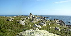
Wingletang Down (St Agnes)

Last updated

Wingletang Down, St Agnes
Site of Special Scientific Interest
South'ard - geograph.org.uk - 84875.jpg
Wingletang Down, looking south
Isles of Scilly UK location map.svg
Red pog.svg
Location within Isles of Scilly
Grid reference SV883076
Coordinates 49°53′17″N6°20′28″W / 49.888°N 6.341°W / 49.888; -6.341 Coordinates: 49°53′17″N6°20′28″W / 49.888°N 6.341°W / 49.888; -6.341
InterestBiological
Area28.9 hectares (0.2890 km2; 0.1116 sq mi)
Notification 1971 (1971)
Natural England website

Wingletang Down is a Site of Special Scientific Interest (SSSI) on the southern side of the island of St Agnes in the Isles of Scilly, England, UK, which is noted for its biological characteristics. The site is managed by the Isles of Scilly Wildlife Trust and is within the Isles of Scilly Heritage Coast and the Isles of Scilly Area of Outstanding Natural Beauty. It is the only site in Great Britain and Ireland for the small fern, least adder's–tongue ( Ophioglossum lusitanicum ). [1] As of 11 September 2009 the SSSI was considered to be in ″unconditional recovering″ condition because European gorse ( Ulex europaeus ) and bramble ( Rubus fruticosus ) are at unacceptable levels. [2]

Contents

History

Forty–three Bronze Age cairns have been recorded, some of which have granite kerbstones and others are linked by hedge walls. A cairn usually indicates a burial site. [3]

On the west side of St Warna's Cove is a stone–lined well that is reputed to be of great antiquity, and close to where the saint is supposed to have come ashore in a coracle after a journey from Ireland. The name Warna is unknown anywhere else as a Celtic saint, and may be the name of a Celtic water goddess. In the past pins were dropped into the well as an offering to encourage storms to drive ships ashore. Wrecks were a vital resource for coastal communities. Ceramic beads from the 17th-century wreck of a Venetian ship can be found on the beach at Beady Pool on Wingletang Bay. [4] [5]

Geology

The underlying rock is Hercynian granite covered by thin, skeletal and podzolic soils on the higher land where there are many weathered outcrops. At the southernmost tip is Horse Point which is almost separated from the rest of St Agnes by a narrow neck of blown sand between two bays; Wingletang Bay and Porth Askin. Along the coast to the west towards St Warna Cove are boulder beaches. [4]

Wildlife and ecology

Wingletang Down is 71 acres (28.9 ha) of maritime heath, dune grassland and scrub reaching a maximum height of 66 feet (20 m) above sea level and is considered by Plantlife to be an Important Plant Area. [6] Due to exposure to salt–laden winds, wind-pruned or "waved" maritime heath has developed on the low nutrient, shallow soils on the higher land, whilst to the south on the deeper sandy soils close to sea–level dune grassland grows. At the southern promontory of Horse Point there is short maritime grass and a tumble of large granite boulders where shallow temporary brackish pools occur. Sea milkwort ( Glaux maritima ) is a rare plant in Scilly and grows here. Sand sedge ( Carex arenaria ) and sand couch ( Elytrigia juncea ) dominate the dune grassland between Wingletang Bay and Porth Askin whilst flowering plants include common storksbill ( Erodium cicutarium ), Portland spurge ( Euphorbia portlandica ) and hemlock water dropwort ( Oenanthe crocata ) which is unusual here as it usually grows in wet habitats. At Beady Pool, which is part of Wingletang Bay, sea kale ( Crambe maritima ) grows on the strandline along with yellow horned poppy ( Glaucium flavum ) and sea spurge ( Euphorbia paralias ). There is a colony of six–spot burnet ( Zygaena filipendulae ) here [7] and in the past ringed plover ( Charadrius hiaticula ) nested. [1] The nationally scarce (but common on all the inhabited islands) early meadow grass ( Poa infirma ) grows in the short maritime grass west of Porth Askin. [8]

The wind pruned maritime heath, on the higher part of the site is dominated by western gorse ( Ulex gallii ), heather ( Calluna vulgaris ) and bell heather ( Erica cinerea ). This heath is unique because all three Ophioglossum species found in the British Isles have been recorded within this small area. [9] [10] [ citation needed ] The largest and easiest to find is adder's–tongue ( Ophioglossum vulgatum ) which is the commonest on the mainland but the rarest in Scilly and has not been seen in the Isles (on St Agnes) since 1990, or on Wingletang Down since 1938. The second which has been recorded on all the inhabited islands is small adders's–tongue ( Ophioglossum azoricum ), which is nationally scarce and found along the western coast of Britain and Ireland north to Orkney and Shetland; there is only one recent Cornish (unconfirmed) record from near Porthgwarra. [8] The third is least adder's–tongue which, in Britain, is known only from this small area of St Agnes, where it was discovered in March 1950 by John Raven who found a colony of about one hundred fronds covering an area of one square metre. [9] Botanists have since found other colonies all within the area of the downs. The probable reason for its late discovery is because the 0.79 inches (2 cm) fronds are found in the winter and turn yellow and disintegrate by early April which is before most botanists are in the area. Since the withdrawal of grazing by cattle and, due to Myxomatosis, the fall in the population of rabbits ( Oryctolagus cuniculus ), some of the colonies are in danger of being smothered by competitive vegetation such as bracken ( Pteridium aquilinum ), European gorse and bramble. [4] Outside of the Isles of Scilly the nearest colony is in Guernsey where it was discovered in 1854. [8]

Related Research Articles

St Agnes, Isles of Scilly Human settlement in England

St Agnes is the southernmost populated island of the Isles of Scilly. Thus the island's Troy Town Farm is the southernmost settlement in the United Kingdom.

Bryher Human settlement in England

Bryher is one of the smaller of the inhabited islands of the Isles of Scilly.

Gugh Tidal island of the isles of Scilly

Gugh could be described as the sixth inhabited island of the Isles of Scilly, but is usually included with St Agnes with which it is joined by a sandy tombolo known as "The Bar" when exposed at low tide. The island is only about 1 km (0.62 mi) long and about 0.5 km (0.31 mi) wide, with the highest point, Kittern Hill at 34 m (112 ft). The geology consists of Hercynian granite with shallow podzolic soils on the higher ground and deeper sandy soils on the lower ground. The former Gugh farm is just north of the neck across the middle of the island between the two hills. The two houses were designed and built in the 1920s by Charles Hamlet Cooper. The name is often mispronounced as "Goo", "Guff" or even "Gogh".

Whitesand Bay

Whitesand Bay is a wide sandy bay near Land's End in west Cornwall, England, United Kingdom. It stretches for one mile between the headlands of Pedn-mên-du and Aire Point. and contains the village of Sennen Cove. It is also a landing point for the Atlantic Crossing 1 international telecommunications cable.

Lamberts Castle Historic hill fort in Dorset, England

Lambert's Castle is an Iron Age hill fort in the county of Dorset in southwest England. Since 1981 it has been designated as a Site of Special Scientific Interest (SSSI) on account of its geology, archaeology and ecology.

Tresco Abbey Gardens

Tresco Abbey Gardens are located on the island of Tresco in the Isles of Scilly, United Kingdom. The 17 acre gardens were established by the nineteenth-century proprietor of the islands, Augustus Smith, originally as a private garden within the grounds of the home he designed and built. The gardens are designated at Grade I in the Register of Historic Parks and Gardens.

St Helens, Isles of Scilly

St Helen's is one of the fifty or so uninhabited islands in the archipelago of the Isles of Scilly and has an approximate area of 0.1885 square kilometres. On the south side of the island is one of the earliest Christian sites in Scilly, an early medieval religious complex, which is thought to be the remains of St Elidius Hermitage, an 8th-century chapel lived in by Saint Lide,. There are also the remains of an isolation hospital used to quarantine sailors with plague. The island is the major part of a Site of Special Scientific Interest and some features have been given the designation of scheduled ancient monument. Access to the island is through chartered or private boat, although there are some season trips throughout the summer. St Helen's is currently managed by the Isles of Scilly Wildlife Trust.

Teän

Teän is an uninhabited island to the north of the Isles of Scilly archipelago between Tresco, 1.5 kilometres (0.9 mi) to the west and St Martin's 300 metres (330 yd) to the east. Approximately 16 hectares in area the island consists of a series of granite tors with the highest point, Great Hill, rising to 40 metres (130 ft) at its eastern end. The low-lying land is overlain with glacial till and outwash gravels with glacial erratics abundant on the north coast beaches which indicates the southern limit of outwash from an ice sheet for which it is designated a Geological Conservation Review site.

Flora and fauna of Cornwall

Cornwall is the county that forms the tip of the southwestern peninsula of England; this area has a mild and warm climate regulated by the Gulf Stream. The mild climate allows rich plant cover, such as palm trees in the far south and west of the county and in the Isles of Scilly, due to sub-tropical conditions in the summer.

White Island, Isles of Scilly

White Island is one of the larger unpopulated islands of the Isles of Scilly, part of the United Kingdom, and lies off the coast of the northernmost populated island of the group, St Martin's, to which it is joined by a tidal causeway, or isthmus. The island is designated as a Site of Special Scientific Interest (SSSI) and a Geological Conservation Review site and is managed by the Isles of Scilly Wildlife Trust on behalf of the Duchy of Cornwall.

Treen Cliff Site of Special Scientific Interest on the Penwith Peninsula in Cornwall, England

Treen Cliff is a Site of Special Scientific Interest (SSSI) located on the Penwith Peninsula in Cornwall, England, UK, 6 miles (9.7 km) south-west of Penzance. First notified in 1951, with a revision in 1973, and a further notification on 1 July 1986, it is 49.3 hectares in area, stretching from grid reference SW387220 to SW402225. Designated for both for its biological and geological interest, part of the site, Treryn Dinas, is a Scheduled Ancient Monument consisting of a "cliff castle" with four ramparts and ditches and the Logan Rock. It is within the Cornwall Area of Outstanding Natural Beauty (AONB), the Penwith Heritage Coast and is part owned and managed by the National Trust.

<i>Ophioglossum lusitanicum</i> species of fern in the family Ophioglossaceae

Ophioglossum lusitanicum, the least adder's-tongue, is a small fern of the family Ophioglossaceae. It is a pan-tropically species categorised as least concern by the IUCN (2001).

Boscastle to Widemouth Coastal Site of Special Scientific Interest in Cornwall, England

Boscastle to Widemouth is a coastal Site of Special Scientific Interest (SSSI) in Cornwall, England, noted for its biological and geological characteristics. The Dizzard dwarf oak woodland is unique and of international importance for its lichen communities, with 131 species recorded.

Godrevy Head to St Agnes

Godrevy Head to St Agnes is a coastal Site of Special Scientific Interest (SSSI) in north Cornwall, England, UK, noted for both its biological and geological characteristics. A number of rare and scarce plant species can be found on the site, along with many breeding seabirds.

Eastern Isles

The Eastern Isles are a group of twelve small uninhabited islands within the Isles of Scilly Area of Outstanding Natural Beauty, part of the Scilly Heritage Coast and a Site of Special Scientific Interest (SSSI) first designated in 1971 for its flora and fauna. They have a long period of occupation from the Bronze Age with cairns and entrance graves through to Iron Age field systems and a Roman shrine on Nornour. Before the 19th century, the islands were known by their Cornish name, which had also become the name of the largest island in the group after the submergence of the connecting lands.

Peninnis Head

Peninnis Head is the southernmost point of St Mary's, Isles of Scilly. The headland is within the Isles of Scilly Area of Outstanding Natural Beauty and part of the Heritage Coast. It is also a Geological Conservation Review site for its Quaternary geomorphology and was first designated a Site of Special Scientific Interest (SSSI) in 1971 for both its biological and geological interests. On the tip of the headland is a squat lighthouse built in 1911 by Trinity House as a replacement for the 17th century lighthouse on St Agnes.

Lower Moors (St Marys)

The Lower Moors is a wetland between Hugh Town and Old Town Bay on St Mary's, the largest island in the Isles of Scilly. The Isles of Scilly are an archipelago off the southwestern tip of the Cornish peninsula of Great Britain.

Porth Hellick Human settlement in England

Porth Hellick is a tidal inlet on the south coast of St Mary’s, the largest island in the Isles of Scilly.

Castle Down

Castle Down is a windswept plateau of maritime heath in the northern part of the island of Tresco, Isles of Scilly. The area has a number of designations including Castle Down (Tresco) Site of Special Scientific Interest (SSSI); is part of the Isles of Scilly Area of Outstanding Natural Beauty; part of the Isles of Scilly Heritage Coast; and part of Plantlife's Isles of Scilly Important Plant Area. There are a number of Schedule Ancient Monument's ranging in age from Bronze Age cairns to castles built in the 16th and 17th centuries to protect the anchorage of New Grimsby harbour.

Arcot Hall Grasslands and Ponds

Arcot Hall Grasslands and Ponds is the name given to a Site of Special Scientific Interest (SSSI) near Cramlington in Northumberland, England, notable as the largest lowland species-rich grassland in North East England. The site is composed of grassland, heath, ponds, and associated damp habitats now rare in Northumberland.

References

  1. 1 2 "Wingletang Down (St Agnes)" (PDF). Natural England . Retrieved 21 April 2012.
  2. Webber, Julie. "Nature on the Map". Natural England. Retrieved 21 April 2012.
  3. Thorgrim. "Wingletang Down – Cairn in England in Scilly Isles". The Megalithic Portal . Retrieved 21 April 2012.
  4. 1 2 3 Parslow, Rosemary (2007). The Isles of Scilly. London: HarperCollins. ISBN   978-0-00-220151-3.
  5. Reid, Neil (2016). Isles of Scilly Guidebook. Friendly Guides. ISBN   978-1-904645-34-4.
  6. "Isles of Scilly". Plantlife . Retrieved 21 April 2012.
  7. Hicks Michael; Hale John (1998). Lepidoptera of St Agnes, Isles of Scilly: a systematic list and analysis of the species recorded on St Agnes, 1992–1997. Privately published.
  8. 1 2 3 CISFBR; Bennallick Ian; French Colin; Parslow Rosemary (2009). Vascular Plants, In Red Data Book for Cornwall and the Isles of Scilly (2nd ed.). Praze-an-Beeble: Croceago Press. pp. 105–157. ISBN   978-1-901685-01-5.
  9. 1 2 Lousley, J E (1971). The Flora of the Isles of Scilly. Newton Abbot: David & Charles. ISBN   0-7153-5465-5.
  10. C. N. Page (1997). The Ferns of Britain and Ireland. Cambridge University Press. p. 260. ISBN   978-0-521-58658-0.