St Agnes, Isles of Scilly

Last updated

St. Agnes
St. Agnes map.png
A map of St. Agnes, with Gugh to the east
Isles of Scilly UK location map.svg
Red pog.svg
St. Agnes
Location within Isles of Scilly
Population82 (2011)
OS grid reference SV881430
Civil parish
  • St Agnes
Unitary authority
Ceremonial county
Region
Country England
Sovereign state United Kingdom
Post town ISLES OF SCILLY
Postcode district TR22
Dialling code 01720
Police Devon and Cornwall
Fire Isles of Scilly
Ambulance South Western
UK Parliament
List of places
UK
England
Cornwall
49°53′28″N6°20′35″W / 49.891°N 6.343°W / 49.891; -6.343

St Agnes (Cornish : Agenys) [1] is the southernmost populated island of the Isles of Scilly. Thus the island's Troy Town Farm is the southernmost settlement in the United Kingdom.

Contents

Description

The sandbar from St. Agnes to Gugh View from obadiahs barrow.jpg
The sandbar from St. Agnes to Gugh

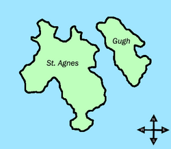
St Agnes joins the island of Gugh by a tombolo, a kind of sandbar, called the Gugh Bar, which is exposed only at low tide. The Gugh is inhabited, with some three residents. The two islands of St Agnes and Gugh together have a population of 85 residents recorded in the 2011 census (73 were recorded in the 2001 census) and a landmass of 366 acres (148 ha). Without the Gugh included, St Agnes is marginally smaller than Bryher in either population or area; however if Gugh is included with St Agnes, it is Bryher that is marginally smaller in area and population.

In earlier times many men from St Agnes earned a living as pilots, guiding transatlantic liners and other vessels through the English Channel. Now the mainstay of the economy is tourism, together with some bulb farming. Accommodation is limited, and St Agnes is the only populated island in the Isles of Scilly which has no hotel. However, it has a few B&Bs and self-catering cottages, an ice cream shop, a campsite, a small post office and general store and a gift shop. It also has a pub (the Turk's Head) and a cafe, although these are closed in the winter.

Settlements

The main population centre is in the north and middle of the island. The southern part of the island is covered by the heather moorland of Wingletang Down.

The settlements are Troy Town (far west), Lower Town (west), Middle Town (central) and Higher Town (east). [2]

Lighthouse

The island's most notable landmark is its lighthouse, which has been converted into living accommodation as the tower no longer contains a light.

Other landmarks

A rock formation on the southwest side of St. Agnes that looks like an elephant StAgnesElephant.JPG
A rock formation on the southwest side of St. Agnes that looks like an elephant

Other landmarks include a standing stone known as the Nag's Head (probably a natural formation). In 1707, many of the sailors who had drowned in the great naval disaster off the Isles of Scilly were reputedly buried on the St Agnes playing field. [3]

Troy Town maze

The Troy Town Maze is said to have been laid out by the son of the lighthouse keeper in 1729, but may be much older. Although called a maze it is strictly a labyrinth with a convoluted path to the centre via seven rings. It is the only one outside Scandinavia made of beach pebbles, which may indicate it to be of Viking origin. References in the Norse sagas tell of raiders coming to Scilly as late as the mid-12th century. Any buried evidence of its origins may have been destroyed during an unofficial rebuild in 1988. [4]

Churches

Bible Christian chapel Former Bible Christian Chapel, St Agnes, Isles of Scilly.jpg
Bible Christian chapel

The primary church of St Agnes is St Agnes' parish church, but the Bible Christians maintained a congregation on the island for over 100 years and built the Bible Christian Chapel, St Agnes in the north of the island in 1874.

St Agnes' Church is a parish church in the Church of England located in the village, dedicated to St Agnes of Rome. The first church was built in the sixteenth or seventeenth century, but it was destroyed in a gale. It was rebuilt in the eighteenth century, but was again destroyed. [5] The current building was built by the islanders in the nineteenth century using the proceeds of the sale of a wreck, and the bell in the church was taken from that wreck. It is a Grade II listed building. In 1821, the church was surveyed by Barnard Sherris of the Incorporated Church Building Society, and a grant was approved for a new west gallery and two new pews in the chancel. [6] The church features stained-glass windows locally made by artists Marigold and Oriel Hicks. [7] St Agnes' Church is within the United Benefice of the Isles of Scilly parishes, which also includes All Saints' Church, Bryher, St Martin's Church, St Martin's, St Mary's Church, St Mary's, St Mary's Old Church, St Mary's, and St Nicholas's Church, Tresco.

Population

YearPopulation
1841243
1861200
1871179
1878150 [lower-alpha 1]
1881148
1891130
1901134
1911102
1921101
193178
195178
196185
197163
198180
199190
200173
201185

Sporting and social life

The Turk's Head, the only pub on St. Agnes TurksHead.JPG
The Turk's Head, the only pub on St. Agnes

Friday evenings in the summer (end of April until start of October) see men's domestic Cornish Pilot Gig racing on Scilly, with the ladies' race on Wednesday. After the race, supporters fill the Turk's Head to discuss the race and to socialise. The pub is open through the summer, but during the winter it only opens on Wednesdays for a pub quiz, and one other night. The pub is supplied from St Austell and stocks a range of beers and ales including Burton ales. [8]

Notable residents

Periglis Cottage, home of Hilda M. Quick Periglis Cottage - geograph.org.uk - 869012.jpg
Periglis Cottage, home of Hilda M. Quick

Periglis Cottage was the home of St Agnes's resident ornithologist Hilda M. Quick.[ citation needed ] She was the author of Birds of the Scilly Isles published in 1964.

Education

St Agnes Base StAgnesSchool.jpg
St Agnes Base

Five Islands Academy (previously Five Islands School) has its St Agnes Base, a primary campus. Secondary pupils board at the St Mary's main campus, [9] staying there on weekdays and coming back and forth to their home islands on weekends. [10]

Students at the sixth-form college level reside and board elsewhere, [11] in mainland Great Britain. Previously the Learning and Skills Council paid for costs of accommodation for sixth-formers. [12]

Natural history

Over one third of the area of St Agnes is designated as Sites of Special Scientific Interest (SSSI). In the south of the island Wingletang Down is noted for its heath, dune grassland and rocky coast and is the only site in Britain where the fern least adder's–tongue (Ophioglossum lusitanicum) grows. Other rare plants include the orchid autumn lady's-tresses ( Spiranthes spiralis ) and early meadow-grass ( Poa infirma ). The only freshwater pools on St Agnes are Big Pool and Little Pool in the north-west of the island which are part of the Big Pool and Browarth Point SSSI. Big Pool shows evidence for inundation [13] by the 1775 Lisbon tsunami that was caused by the 1755 Lisbon earthquake. The vegetation has some brackish influence because of occasional influx of the sea during winter storms with rushes such as saltmarsh rush ( Juncus gerardi ) and sea club–rush ( Scirpus maritimus ). The surrounding grassland, which is also a cricket pitch, is notable for the clovers amongst its flora including western clover ( Trifolium occidentale ), suffocated clover ( T. suffocatum ) and subterranean clover ( T. subterraneum ). Other plants include adder's-tongue ( Ophioglossum vulgatum ) and small adder's-tongue ( O. azoricum ). [14] [15]

Vagrant birds

St Agnes is visited by birdwatchers, particularly during the ″Scilly season″ of September and October. Among the many vagrant birds which have been found here around this time are the following, which were all ″firsts″ for Britain:

In addition:

Among rare vagrants recorded at other times of year are the following:

Civil parish and ward

The isles of Scilly comprising the civil parish and ward of St Agnes shown in red. St Agne's Isles of Scilly UK parish locator map.png
The isles of Scilly comprising the civil parish and ward of St Agnes shown in red.

St Agnes is one of the five civil parishes of the Isles of Scilly, which are also wards. The civil parish and ward include Gugh and several uninhabited islands and rocks, including the Western Rocks, Annet, Rosevear, Pednathise Head (the southernmost land in the UK) and the Bishop Rock. [26] St Agnes returns one councillor to the Council of the Isles of Scilly, the same as the other "off-island" wards. The civil parish is not functional, however, and there is no council or meeting.

See also

Notes

  1. estimated to be nearly 150 in 25 households; the heads of 17 of these were surnamed Hicks (still a common surname on the island)

Further reading

Related Research Articles

<span class="mw-page-title-main">Tresco, Isles of Scilly</span> Human settlement in England

Tresco is the second-biggest island of the Isles of Scilly. It is 297 ha (1.15 sq mi) in area, measuring about 3.5 km (2.2 mi) by 1.75 km (1.09 mi).

<span class="mw-page-title-main">Hugh Town</span> Human settlement in England

Hugh Town is the largest settlement on the Isles of Scilly and its administrative centre. The town is situated on the island of St Mary's, the largest and most populous island in the archipelago, and is located on a narrow isthmus which joins the peninsula known as the Garrison with the rest of the island.

<span class="mw-page-title-main">Bryher</span> Human settlement in England

Bryher is one of the smallest inhabited islands of the Isles of Scilly, with a population of 177 in 2021, spread across 134 hectares (1.34 km2). Bryher exhibits a procession of prominent hills connected by low-lying necks and sandy bars. Landmarks include Hell Bay, famous for shipwrecks in the 18th and 19th centuries, Shipman Head, which was fortified in the Iron Age and where the tumbled ramparts of an Iron Age castle remain, and All Saints' Church, originally constructed in 1742. The island has two quays, Church Quay and Bar Quay.

<span class="mw-page-title-main">Annet, Isles of Scilly</span>

Annet is the second-largest of the fifty or so uninhabited Isles of Scilly, one kilometre west of St Agnes with a length of one kilometre and approximately 22 hectares in area. The low-lying island is almost divided in two by a narrow neck of land at West Porth which can, at times, be covered by waves. At the northern end of the island are the two granite carns of Annet Head and Carn Irish and three smaller carns known as the Haycocks. The rocky outcrops on the southern side of the island, such as South Carn, are smaller. Annet is a bird sanctuary and the main seabird breeding site in Scilly.

<span class="mw-page-title-main">Gugh</span> Tidal island of the isles of Scilly

Gugh could be described as the sixth inhabited island of the Isles of Scilly, but is usually included with St Agnes with which it is joined by a sandy tombolo known as "The Bar" when exposed at low tide. The island is only about 1 km (0.62 mi) long and about 0.5 km (0.31 mi) wide, with the highest point, Kittern Hill at 34 m (112 ft). The geology consists of Hercynian granite with shallow podzolic soils on the higher ground and deeper sandy soils on the lower ground. The former Gugh farm is just north of the neck across the middle of the island between the two hills. The two houses were designed and built in the 1920s by Charles Hamlet Cooper.

<span class="mw-page-title-main">Council of the Isles of Scilly</span> Local government authority in Cornwall

The Council of the Isles of Scilly is a sui generis unitary local government authority covering the Isles of Scilly off the west coast of Cornwall. It is currently made up of 16 seats, with all councillors being independents. The council was created in 1890 as the Isles of Scilly Rural District Council and was renamed in 1974.

<span class="mw-page-title-main">Teän</span>

Teän is an uninhabited island to the north of the Isles of Scilly archipelago between Tresco, 1.5 kilometres (0.9 mi) to the west, and St Martin's, 300 metres (330 yd) to the east. Approximately 16 hectares in area, the island consists of a series of granite tors with the highest point, Great Hill, rising to 40 metres (130 ft) at its eastern end. The low-lying land is overlain with glacial till and outwash gravels with glacial erratics abundant on the north coast beaches, which indicates the southern limit of outwash from an ice sheet for which it is designated a Geological Conservation Review site.

<span class="mw-page-title-main">Isles of Scilly</span> Group of islands off the south-westernmost point of mainland Britain

The Isles of Scilly is an archipelago off the southwestern tip of Cornwall, England, United Kingdom. One of the islands, St Agnes, is over four miles further south than the most southerly point of the British mainland at Lizard Point.

<span class="mw-page-title-main">All Saints' Church, Bryher</span> Church in Isles of Scilly, England

All Saints' Church is a Grade II listed parish church in the Church of England located in Bryher, Isles of Scilly.

<span class="mw-page-title-main">St Mary's Church, St Mary's</span> Church in Isles of Scilly, England

St Mary's Church, St Mary's is a parish church in the Church of England located in Hugh Town, St Mary's, Isles of Scilly, UK. The Church was consecrated on 7 September 1838 and replaced the church at Old Town which was inconvenient for the Hugh Town population and in need of repair.

<span class="mw-page-title-main">St Mary's Old Church, St Mary's</span> Church in Cornwall, England

St Mary's Old Church, St Mary's is a parish church in the Church of England located in Old Town on St Mary's, Isles of Scilly, Cornwall, United Kingdom.

<i>Ophioglossum lusitanicum</i> Species of fern in the family Ophioglossaceae

Ophioglossum lusitanicum, the least adder's-tongue, is a small fern of the family Ophioglossaceae. It is a temperate species categorised as least concern by the IUCN (2001).

The years 1980–1989 in birding and ornithology.

<span class="mw-page-title-main">Wingletang Down (St Agnes)</span>

Wingletang Down is a Site of Special Scientific Interest (SSSI) on the southern side of the island of St Agnes in the Isles of Scilly, England, UK, which is noted for its biological characteristics. The site is managed by the Isles of Scilly Wildlife Trust and is within the Isles of Scilly Heritage Coast and the Isles of Scilly Area of Outstanding Natural Beauty. It is the only site in Great Britain and Ireland for the small fern, least adder's–tongue. As of 11 September 2009 the SSSI was considered to be in ″unconditional recovering″ condition because European gorse and bramble are at unacceptable levels.

<span class="mw-page-title-main">Lower Moors (St Mary's)</span>

The Lower Moors is a wetland between Hugh Town and Old Town Bay on St Mary's, the largest island in the Isles of Scilly. The Isles of Scilly are an archipelago off the southwestern tip of the Cornish peninsula of Great Britain.

The Isles of Scilly are an archipelago 45 km (28 mi) off Land's End, Cornwall. Little of the fauna on, above or in the seas surrounding the isles was described prior to the 19th century, when birds and fish started to be described. Most records of other animals date from the 20th century onwards.

<span class="mw-page-title-main">Isles of Scilly Museum</span> Museum in Isles of Scilly, Cornwall, UK

The Isles of Scilly Museum is a museum in the Isles of Scilly, off Cornwall, England. As of 2023 the museum has no building but displays a selection of its collection in a range of locations on the islands.

References

  1. "Akademi Kernewek - Henwyn Tyller".
  2. "Map of St Agnes, 1:25,000". streetmap.co.uk. Retrieved 19 April 2021.
  3. The Council of the Isles of Scilly Association Commemoration Group 2007. "HMS ASSOCIATION". Shipwrecks UK. Retrieved 23 February 2018.{{cite web}}: CS1 maint: numeric names: authors list (link)
  4. Sawyer, Katharine (August 2006). "Scilly Through The Ages – Troy Town Maze". Scilly Now and Then. No. 6.
  5. "St Agnes Church, St Agnes, Scilly Isles". Lambeth Palace Library - Database of Manuscripts and Archives. 23 September 2023. Archived from the original on 23 September 2023.
  6. "St Agnes". IOS Churches. Retrieved 23 September 2023.
  7. Protz, Roger (2000) Britain's 500 Best Pubs. London: Carlton Books ISBN   978-1-85868-826-8;; pp. 45-46
  8. "Contact Us". Five Islands Academy . Retrieved 7 December 2018.
  9. "Home to School Travel". Isles of Scilly Council. Retrieved 8 December 2018.
  10. "Schools & Colleges". Isles of Scilly Council. Retrieved 8 December 2018.
  11. "Education". Council of the Isles of Scilly. 14 October 2002. Archived from the original on 14 October 2002. Retrieved 8 December 2018. There is no post-16 provision on the Islands, students leaving the Isles of Scilly (VC) Federated School attend at colleges/schools with 6th forms on the mainland.[...]
  12. Banerjee, D.; et al. (1 December 2001). "Scilly Isles, UK: optical dating of a possible tsunami deposit from the 1755 Lisbon earthquake". Quaternary Science Reviews. 20 (5–9): 715–718. Bibcode:2001QSRv...20..715B. doi:10.1016/S0277-3791(00)00042-1.
  13. "Big Pool and Browarth Point (St Agnes)" (PDF). Natural England. Retrieved 3 December 2011.
  14. "Wingletang Down (St Agnes)" (PDF). Natural England. Retrieved 3 December 2011.
  15. Harris, G J; Parslow J L F (November 1960). "Northern Waterthrush in the Isles of Scilly: a bird new to Great Britain and Ireland". British Birds. 53 (11): 513–8. Retrieved 5 July 2013.
  16. Parslow, Jon L; Carter M J (1965). "Bobolink in the Isles of Scilly: a bird new to Great Britain and Ireland". British Birds. 58: 208–214.
  17. Osborne, Ken (2002). "Birding Hotspots 1: The Parsonage". Isles of Scilly Bird and Natural History Review 2001: 165–7.
  18. Edwards, K D; Osborne K C (1972). "Hooded Warbler in the Isles of Scilly: a species new to Britain and Ireland". British Birds. 65: 203–5.
  19. Dukes, Paul A (1980). "Semipalmated Plover: new to Britain and Ireland". British Birds. 73: 458–464. Retrieved 4 July 2013.
  20. Robinson, Peter (2003). Birds of the Isles of Scilly. London: Christopher Helm. p. 608. ISBN   0-7136-6037-6.
  21. Dukes, Paul A (March 1995). "Wood Thrush in Scilly: new to Britain and Ireland". British Birds . 88 (3): 133–5. Retrieved 1 July 2013.
  22. Fisher Ashley and Flood Bob (2005). "Cream-coloured Courser – First for Scilly, September 28, 2004". Isles of Scilly Bird and Natural History Review 2004: 138–9.
  23. Quick, Hilda (1952). "Blue-cheeked Bee-eater in Scilly: A new British bird". British Birds. 45: 225–7. Retrieved 5 July 2013.
  24. Hudson, D.C. (2010) Isles of Scilly Bird and Natural History Review 2009. Isles of Scilly Bird Group.
  25. Ordnance Survey 1:25,000 map

Commons-logo.svg Media related to St Agnes, Isles of Scilly at Wikimedia Commons