St Levan
| |
---|---|
![]() Parish church of St Levan | |
Location within Cornwall | |
Population | 459 (2011) |
OS grid reference | SW3822 |
Civil parish |
|
Unitary authority | |
Ceremonial county | |
Region | |
Country | England |
Sovereign state | United Kingdom |
Post town | PENZANCE |
Postcode district | TR19 |
Dialling code | 01736 |
Police | Devon and Cornwall |
Fire | Cornwall |
Ambulance | South Western |
UK Parliament | |
St Levan (Cornish : Selevan [1] ) is a civil parish in Cornwall, England, United Kingdom. The parish is rural with a number of hamlets of varying size with Porthcurno probably being the best known. Hewn out of the cliff at Minack Point and overlooking the sea to the Logan Rock is the open-air Minack Theatre, the inspiration of Rowena Cade in the early 1930s.
It is named for St. Salomon of Cornwall, father of St. Kubi. The brythonic form of the name 'Solomon' is 'Selevan', which was later wrongly interpreted as 'Sen Levan' , ie 'Saint Levan'.
St Levan lies within the Cornwall Area of Outstanding Natural Beauty (AONB) and the South West Coast Path, which follows the coast of south-west England from Somerset to Dorset passes by on the cliffs. There are two Sites of Special Scientific Interest (SSSI), designated for the vegetation and geology, and Gwennap Head in particular, is favoured by birdwatchers, many who travel the length and breadth of Britain to watch rare seabirds.
The parish church is about eight miles (13 km) south west of Penzance. [2] The parish measures 2,400 acres (10 km2) and the population at the 2011 census was 459. The river in the valley at Nanjizal forms the parish boundary with Sennen and is 3 miles south of the Land's End. From Nanjizal heading south and east, via Gwennap Head, there is 4 miles of coast to Penberth Cove and the boundary with St Buryan. The parish encompasses a number of small settlements which include Bottoms, Penberth, Polgigga, Porthcurno, Porthgwarra, Trebehor, Treen (the chief village) and Trethewey. [3] Both Penberth and Porthgwarra in the past had small fishing fleets despite not having a harbour; the boats were hauled up the slipways when not in use. A small fleet continues to fish out of Penberth, for bass ( Dicentrarchus labrax ), crabs and mackerel (Scomber scombrus). [3]
Neolithic flints have been found dating human activity in the area to 5000 years ago. Fifteen hundred pieces of worked flint and chert from the Bronze Age were found during the 1914 excavation at Pedn-men-an-mere [3] [4] and an Iron Age cliff castle at Treryn Dinas may date back 2000 years or more. [5]
Many of the hamlets and farms with Cornish prefixes such at Bos and Tre (and possibly Ros) can trace their names back to 600–700 AD while Chy dates back to the 11th- or 12th-century. The first documentary evidence of a place name is Rospletha, which is mentioned in 1244 and the rest of the other farms are recorded over the next one hundred years. [3] Much of the land belonged to the manor of Mayon, Sennen and in the early 17th-century the land was divided between six heiresses, one of whom married John St Aubyn. A later John St Aubyn, became the first Baron St Levan of St Michael's Mount. The St Aubyn's estate purchased the freehold estate of Roskestral in April 1885 for £5,000. As well as the farmhouse and farm buildings there was 96 acres (39 ha) of land including the ″cliff lands″ around Carn Glaze. [6] Much of Porthgwarra, the land around Gwennap Head, as well as the farms Higher Bosistow, Roskestral, Sawah, Trebehor and Trevean are still part of the St Aubyn Estate. [3] [7] Mr T Bedford Bolitho bought the Rospletha estate for £1500 in 1883. The 14 acres (5.7 ha) estate was described as ″fertile land″ and there was also a share of 50 acres (20 ha) cliff. [8] [9]
Above the sandy beach at Porthchapel is a ruined rectangular building with a large flat granite slab and spring known as St Levan's Well. Below, cut into the cliff slope, are two buildings believed to be an early chapel and cell. The remains possibly date to the 7th- or 8th-century. [10] St Levan's Church is situated in a small valley, inland from Porthchapel. It dates mainly from the 15th-century with earlier font, north transept and nave/chancel. [11] Until 1864 the church was a chapelry of the Royal Peculiar of the Deanery of St Buryan. It is now part of the united benefice of St Buryan and St Sennen. There are also two Wesleyan Methodists chapels at Treen (1834) and Trethewey (1868). [12] [13]
There are five Cornish crosses in the parish; one in the churchyard, one on the churchyard wall and the others at Rospletha, Sawah and Trebehor. [14]
The first telegraph cable, (from Carcavelos, near Lisbon) was laid on Porthcurno beach in 1870. Lisbon had already been linked to Bombay, making Porthcurno the British terminal of the Empire's telegraph network. A land link was provided to London helping to make Porthcurno a centre of world communications. The Eastern Telegraph Company was formed in 1872, later to become Cable & Wireless. Porthcurno was also a training centre, sending operators all over the world. [3] [15]
For the purposes of local government St Levan is a civil parish and every four years elects a parish council consisting of ten councillors. The principal local authority is Cornwall Council. Since local government boundary changes in 2021, the parish falls under the electoral ward of Land's End.
Much of the coast of St Levan parish is designated as a Site of Special Scientific Interest (SSSI) and noted for the vegetation of waved maritime heath and for the geology. Heaths are widespread worldwide but are fast disappearing and considered a rare habitat in Europe. Rock sea lavender ( Limonium loganicum ) is an endemic plant that is found only in the parish of St Levan. All the colonies are within protected areas but may be vulnerable from climbers or walkers on the lower slopes where it occurs. [16]
Treen Cliff SSSI extends from Porthcurno beach in the west to Penberth Cove in the east. Several rare plant species occur and the site is of particular importance for its maritime heath. [17] Part of the site, Treryn Dinas, is a Scheduled Ancient Monument consisting of a "cliff castle" with four ramparts and ditches, and the Logan Rock was part of the tour of the Land's End area for Victorian tourists. The Porthgwarra to Pordenack Point (SSSI) is noted for its vegetation, and for being of considerable ornithological interest; especially for passage migrants. It is renowned for its relative abundance of passing marine bird species with many common species such as northern gannet (Morus bassanus), Manx shearwater (Puffinus puffinus), common guillemot, (Uria aalge) and razorbill (Alca torda), as well as rarer birds such as Balearic shearwater (Puffinus mauretanicus) and Cory's shearwater (Calonectris borealis). [18] The headland of Tol-pedn (or Gwennap Head) is favoured by birdwatchers and many travel the length and breadth of Britain to track rare seabirds. [19] [20]
Some of the butterflies that can be found on the coast include grayling ( Hipparchia semele ), silver-studded blue ( Plebejus argus ), small pearl-bordered fritillary ( Boloria selene ) and wall ( Lasiommata megera ). There is also a day-flying moth, the thrift clearwing ( Synansphecia muscaeformis ); the adult is a bee mimic and the larva feeds on thrift ( Armeria maritima ).
St Levan CP School is St Levan's community primary school, located in the hamlet of Bottoms. It is a very small school. Its current head teacher is Susannah Storey.
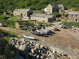
Lamorna is a village, valley and cove in west Cornwall, England, UK. It is on the Penwith peninsula approximately 4 miles (6 km) south of Penzance. Lamorna became popular with the artists of the Newlyn School, including Alfred Munnings, Laura Knight and Harold Knight, and is also known for former residents Derek and Jean Tangye who farmed land and wrote "The Minack Chronicles".
The Runnel Stone, or Rundle Stone, is a hazardous rock pinnacle about 1-mile (1.6 km) south of Gwennap Head, Cornwall, England, United Kingdom. It used to show above the surface at low water until a steamship struck it in 1923.
Porthcurno is a small village covering a small valley and beach on the south coast of Cornwall, England in the United Kingdom. It is the main settlement in a civil and an ecclesiastical parish, both named St Levan, which comprise Porthcurno, diminutive St Levan itself, Trethewey and Treen.
Treen is a small village in the parish of St Levan, in the far west of Cornwall, England, United Kingdom. It is about 3 miles (4.8 km) inland from Land's End on a short unclassified spur road from the B3315. Treen overlooks the Penberth Valley and sits about 1 kilometre (0.62 mi) inland from Treryn Dinas, an Iron Age promontory fort, or cliff castle, with five lines of fortification. On the headland is the Logan Rock and to the west is Pedn Vounder tidal beach, which is popular with naturists. Treen Cliff is to either side of Treryn Dinas. The village has a popular pub, The Logan Rock Inn, a village shop, cafe and campsite with views to both Logan Rock and nearby Porthcurno.
St Buryan is a village and former civil parish, now in the parish of St Buryan, Lamorna and Paul in Cornwall, England, United Kingdom. In 2011 the parish had a population of 1412.
The Logan Rock near the village of Treen in Cornwall, Britain, UK, is an example of a logan or rocking stone. Although it weighs some 80 tons, it was dislodged in 1824 by a group of British seamen, intent on showing what the Navy could do. However following complaints from local residents for whom the rock had become a tourist attraction and source of income, the seamen were forced to restore it. Today the Logan Rock still rocks, but with much less ease than it did in the past. The South West Coast Path, which follows the coast of south-west England from Somerset to Dorset passes by on the cliffs to the north.
Penberth is a valley, coastal village and cove on the Penwith peninsula in Cornwall, England. It is approximately 7 miles (11 km) southwest of Penzance. Most of the village is within the parish of St Buryan and the boundary with St Levan follows the Penberth river.
Nanjizal, also known as Mill Bay, is a beach and cove in the civil parish of St Levan, Cornwall, on the south-western coast of Great Britain. Situated one mile to the south-east of Land's End, Nanjizal has no direct access via road, and is usually reached via the South West Coast Path from Land's End in the north, or from Porthgwarra to the south. Nanjizal is also a noted bird watching location.
Gurnard's Head is a prominent headland on the north coast of the Penwith peninsula in Cornwall, England. The name is supposed to reflect that the rocky peninsula resembles the head of the gurnard fish.
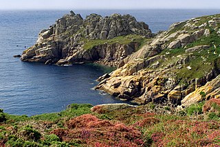
Treryn Dinas is a headland near Treen, on the Penwith peninsula between Penberth Cove and Porthcurno in Cornwall, England.
Gwennap Head is a headland on the south coast of the Penwith peninsula, Cornwall, United Kingdom. It is within the parish of St Levan and approximately 4 miles (6.4 km) south of Land's End, and less than 1 mile (1.6 km) north-west of Porthgwarra, the nearest village. The area of Gwennap Head is designated as part of the Penwith Heritage Coast and also designated as part of the Cornwall Area of Outstanding Natural Beauty. The South West Coast Path closely follows the coastline around the headland.
Polgigga is a hamlet in west Cornwall, England, United Kingdom, on the B3315 Land's End to Penzance road and within the civil parish of St Levan.
St Levan Church, St Levan is a parish church in the Church of England located in St Levan, Cornwall, United Kingdom. Until 1864 the church was a chapelry of the Royal Peculiar of the Deanery of St Buryan. It is now part of the united benefice of St Buryan and St Sennen.
Treen Cliff is a Site of Special Scientific Interest (SSSI) located on the Penwith Peninsula in Cornwall, England, UK, 6 miles (9.7 km) south-west of Penzance. First notified in 1951, with a revision in 1973, and a further notification on 1 July 1986, it is 49.3 hectares in area, stretching from grid reference SW387220 to SW402225. Designated for both for its biological and geological interest, part of the site, Treryn Dinas, is a Scheduled Ancient Monument consisting of a "cliff castle" with four ramparts and ditches and the Logan Rock. It is within the Cornwall Area of Outstanding Natural Beauty (AONB), the Penwith Heritage Coast and is part owned and managed by the National Trust.
Porthgwarra to Pordenack Point is a coastal Site of Special Scientific Interest (SSSI) in west Cornwall, England, noted for its biological characteristics. The South West Coast Path runs through the SSSI.
Cornish promontory forts, commonly known in Cornwall as cliff castles, are coastal equivalents of the hill forts and Cornish "rounds" found on Cornish hilltops and slopes. Similar coastal forts are found on the north–west European seaboard, in Normandy, Brittany and around the coastlines of the British Isles, especially in Wales, Scotland and Ireland. Many are known in southwest England, particularly in Cornwall and its neighbouring county, Devon. Two have been identified immediately west of Cornwall, in the Isles of Scilly.
St Buryan was an electoral division of Cornwall in the United Kingdom which returned one member to sit on Cornwall Council between 2009 and 2021. It was abolished at the 2021 local elections, being succeeded by Land's End, Ludgvan, Madron, Gulval and Heamoor, and Mousehole, Newlyn and St Buryan.
Land's End is an electoral division of Cornwall in the United Kingdom which returns one member to sit on Cornwall Council. It was created at the 2021 local elections, being created from the former divisions of St Buryan, and St Just in Penwith. The current councillor is Brian Clemens, an Independent.