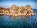
Logan Rock

Last updated

Logan Rock
Logan Rock Treen closeup.jpg
Close-up of the Logan Rock near Treen
Southwest Cornwall UK location map.svg
Archaeological site icon (red).svg
Shown within Southwest Cornwall
Location Cornwall
Coordinates 50°02′29″N5°38′11″W / 50.041361°N 5.636468°W / 50.041361; -5.636468
Typelogan or rocking stone.
History
MaterialStone
Site notes
ConditionRestored
Public accessOpen

The Logan Rock (Cornish : Men Omborth, meaning balanced stone) [1] near the village of Treen in Cornwall, England, UK, is an example of a logan or rocking stone. Although it weighs some 80 tons, it was dislodged in 1824 by a group of British seamen, intent on showing what the Navy could do. However following complaints from local residents for whom the rock had become a tourist attraction and source of income, the seamen were forced to restore it. Today the Logan Rock still rocks, but with much less ease than it did in the past. The South West Coast Path, which follows the coast of south-west England from Somerset to Dorset passes by on the cliffs to the north. [2]

Contents

Geography

The rock is a ninety-ton granite boulder perched on the edge of the cliffs overlooking the English Channel, on a headland one mile south of Treen. The rock is within Treryn Dinas, an Iron Age promontory fort, or cliff castle, with five lines of fortification. [3] The rock is finely balanced due to the actions of weathering, and prior to its restoration in 1824 it could be rocked by applying only a little pressure. As well as the logan stone itself, the name Logan Rock is also applied to the surrounding tip of the headland. Cripp's Cove lies to the east beneath the rock. A number of stacks are located around the edge of Logan Rock including Great Goular, Horrace, and Seghy. The area is within the Treen Cliff Site of Special Scientific Interest (SSSI), notified in 1951 for its marine heathland and rare plants. [4] It is within the Cornwall Area of Outstanding Natural Beauty (AONB), [5] the Penwith Heritage Coast [6] and is owned and managed by the National Trust.

Logan Rock Treen Cornwall Logan Rock Treen Cornwall.jpg
Logan Rock Treen Cornwall
Beach view of Logan Rock Treen Cornwall Logan Rock Treen Cornwall 2.jpg
Beach view of Logan Rock Treen Cornwall

The Runnel Stone Marine Conservation Zone was designated on 29 January 2016, covers 7¾ sq. mi. (20 km2) and is based on a 2¼ mile (3.5 km) arc measured from the National Coastwatch Institution lookout based at Gwennap Head. [7] Included is much of the coast from Gwennap Head to Hall Dinas on the east side of Treryn Dinas. The MCZ protects habitats ranging from exposed rock on the coast to soft sediments on the sea floor and animals such as pink sea fan ( Eunicella verrucosa ) which can be found on the eastern side of the headland. [8]

Name

The original Cornish language name for the rock, recorded in 1870 as Men Amber, is Men Omborth, meaning balanced stone. [9] The word "logan" (properly pronounced "logg-un") is probably derived from the word "log", which in an English dialect[ specify ] means "to rock". In fact, in some parts of the UK, rocking stones or logan stones are called logging stones. Bray, writing in 1832, notes the expression 'to log the child's cradle' in relation to logan stone as an example of ancient British dialect recorded on Dartmoor in Devon. [10]

Some have suggested that it comes from a Cornish expression for the movement that someone makes when drunk. Davies Gilbert writes:

It may be observed that I have always used the words Loging Rock for the celebrated stone at Trereen Dinas. Much learned research seems to have been idly expended on the supposed name, "Logan Rock." To log is a verb in general use throughout Cornwall for vibrating or rolling like a drunken man; and is frequently heard in provincial pronunciation for tug, characteristic of the modern present participle. The Loging Rock is, therefore, strictly descriptive of its peculiar motion.

The Cornish word Leghen means "a thin flat stone", whilst its root word, Legh, can also mean "rickets", [11] a disease caused by deficiency of vitamin D and Calcium which can lead to bone deformity.

It should also be noted that the name for rocking stones could be a modified form of the Danish word "logre," which means 'to wag the tail,' and this suggests possible Norse origin. Danes in particular established a kingdom in Great Britain before 1000 AD, Norway maintained nominal control over the Hebrides in northern Scotland until the late Middle Ages, and Vikings frequently raided along the British coastal areas between 800 and 1000 AD Thus, a Norse origin for the word Logan, while speculative, cannot be ruled out.

Story of the rock

The Logan Rock (top right) in context Logan Rock from below.jpg
The Logan Rock (top right) in context

The Logan Rock is one of the best known rocking stones for several reasons. For example, Modred, in William Mason's dramatic poem "Caractacus," addressing the characters Vellinus and Elidurus, says of the Logan Rock:

Thither, youths,
Turn your astonish'd eyes; behold yon huge
And unhewn sphere of living adamant,
Which, poised by magic, rests its central weight
On yonder pointed rock: firm as it seems,
Such is the strange and virtuous property,
It moves obsequious to the gentlest touch
Of him whose breast is pure; but to a traitor,
Tho' ev'n a giant's prowess nerv’d his arm,
It stands as fixt as Snowdon.

Pednvounder beach with Logan Rock in the background PednVounderBeach.JPG
Pednvounder beach with Logan Rock in the background

However, another reason that the Logan Rock of Treen is remembered is that it was the centre of a famous drama. In April 1824, Lieutenant Hugh Goldsmith, R.N. (nephew of the poet Oliver Goldsmith), and ten or twelve of his crew of the cutter HMS Nimble, armed with bars and levers rocked the huge granite boulder until it fell from its cliff-top perch. Goldsmith was apparently motivated to disprove the claim of Dr Borlase, who wrote in Antiquities of Cornwall in 1754 that:

In the parish of S. Levan, there is a promontory called Castle Treryn. This cape consists of three distinct groups of rocks. On the western side of the middle group near the top, lies a very large stone, so evenly, poised that any hand may move it to and fro; but the extremities of its base are at such a distance from each other, and so well secured by their nearness to the stone which it stretches itself upon, that it is morally impossible that any lever, or indeed force, however applied in a mechanical way, can remove it from its present situation.

The Logan Rock (circled) from the Pednvounder beach sand bar Logan rock on headland.jpg
The Logan Rock (circled) from the Pednvounder beach sand bar

Goldsmith was determined to demonstrate that nothing was impossible when the courage and skill of British seamen were engaged. The Logan Rock slid aside and was caught in a narrow crevice (it did not fall from the cliff as claimed by some).

This upset the local residents considerably, since Logan Rock had been used to draw tourists to the area. Treen had become a lucrative tourist destination. Sir Richard R. Vyvyan was particularly unhappy. The local residents demanded that the British Admiralty strip Lieutenant Goldsmith of his Royal Navy commission unless he restored the boulder to its previous position at his own expense.

However, Davies Gilbert persuaded the Lords of the Admiralty to lend Lieutenant Goldsmith the required apparatus for replacing the Logan Rock. The Admiralty sent thirteen capstans with blocks and chains from the dock yard at Plymouth, and contributed £25 towards expenses. Gilbert also raised more funds. [12]

Three anchor holes drilled into the granite next to the Logan Rock Anchor holes in the granite at Logan Rock Cornwall.jpg
Three anchor holes drilled into the granite next to the Logan Rock

After months of effort, at 4.20pm on Tuesday, 2 November 1824, in front of thousands of spectators and with the help of more than sixty men and block and tackle, the Logan Rock was finally repositioned and returned to "rocking condition" (Michell 1974). Apparently the total final cost of this enterprise was £130 8s 6d. A copy of the original receipt for this expenditure can be found today in The Logan Rock public house in Treen. However, it is not clear how much of the remaining £105 Goldsmith had to make up out of his own pocket.

For some time after, the rock was kept chained and padlocked, but eventually these restrictions were removed, and the rock was set free. Tourism declined[ when? ] and this was blamed on the condition of Logan Rock. For a while, Treen was nicknamed 'Goldsmith's Deserted Village'. The anchor holes used to haul the huge rock back into place are still visible in the surrounding rocks. However, it apparently no longer vibrates or "logs" as easily as it did before. [13] Francis Kilvert on his visit on 27 July 1870:

At the foot of the steep rock on which the Logan Stone is balanced a man stood ready to show the way up, and when he saw me coming he began to run up just like a monkey. His action was so sudden, strange and wild, and so exactly that of a monkey clambering up the bars of his cage, that I looked to see whether he had a tail. He helped me up capitally with knee and hand. I could never have got up by myself for the rock faces were very steep, smooth and slippery. ..... The guide first put his shoulder under the Stone and rocked it, and then I did the same. It rocks perceptibly, though very slightly. But it has never rocked so well and easily since it was wilfully thrown down. [14]

Nonetheless, local historian Craig Weatherhill asserts that a series of rhythmic heaves against the south-western corner of the rock will set it moving, after which, the motion can be kept going with the efforts of one hand. He also mentions another smaller logan on the headland, the Lady Logan Rock, which legend tells is a giantess petrified by curses from the dying husband she had just murdered.

On an 1879 visit, Alfred Phillips of Kilburn, found that he ″ ... was able to shake with little difficulty″. [15]

In one of her last works, a biography of her childhood, Virginia Woolf mentions visiting Logan rock with her father and setting it rocking. The episode probably occurred in the early 1890s, when Woolf spent each summer in nearby St Ives. [16]

Logan Rock is described in R.M. Ballantyne's Deep Down. [17]

Inglis Gundry wrote an opera called The Logan Rock which was premiered at the Minack Theatre in 1956 with Edith Coates singing and Marcus Dods conducting.

"Observer", a letter writer to the Cornishman in 1879, uses the "venerable belief of our fore-fathers" who believed in the St Levan witches riding over the Logan Rock, to dispel the contemporary belief, that electric light (which was being introduced to Penzance) was dangerous. [18]

The 1997 album Richard D. James Album by Aphex Twin (who was raised in Cornwall) includes a track called "Logan Rock Witch".

Related Research Articles

<span class="mw-page-title-main">Land's End</span> Human settlement in England

Land's End is a headland and tourist and holiday complex in western Cornwall, England, on the Penwith peninsula about eight miles (13 km) west-south-west of Penzance at the western end of the A30 road. To the east of it is the English Channel, and to the west the Celtic Sea.

<span class="mw-page-title-main">Penwith</span> Area in west Cornwall, England

Penwith is an area of Cornwall, England, located on the peninsula of the same name. It is also the name of a former local government district, whose council was based in Penzance. The area is named after one of the ancient administrative hundreds of Cornwall which derives from two Cornish words, penn meaning 'headland' and wydh meaning 'at the end'.

<span class="mw-page-title-main">Runnel Stone</span> Hazardous rock pinnacle in Cornwall, UK

The Runnel Stone, or Rundle Stone, is a hazardous rock pinnacle about 1-mile (1.6 km) south of Gwennap Head, Cornwall, England, United Kingdom. It used to show above the surface at low water until a steamship struck it in 1923.

<span class="mw-page-title-main">Porthcurno</span> Village in Cornwall, England

Porthcurno is a small village covering a small valley and beach on the south coast of Cornwall, England in the United Kingdom. It is the main settlement in a civil and an ecclesiastical parish, both named St Levan, which comprise Porthcurno, diminutive St Levan itself, Trethewey and Treen.

<span class="mw-page-title-main">Treen, St Levan</span> Human settlement in England

Treen is a small village in the parish of St Levan, in the far west of Cornwall, England, United Kingdom. It is about 3 miles (4.8 km) inland from Land's End on a short unclassified spur road from the B3315. Treen overlooks the Penberth Valley and sits about 1 kilometre (0.62 mi) inland from Treryn Dinas, an Iron Age promontory fort, or cliff castle, with five lines of fortification. On the headland is the Logan Rock and to the west is Pedn Vounder tidal beach, which is popular with naturists. Treen Cliff is to either side of Treryn Dinas. The village has a popular pub, The Logan Rock Inn, a village shop, cafe and campsite with views to both Logan Rock and nearby Porthcurno.

Dinas may refer to:

<span class="mw-page-title-main">Priest Cove</span>

<span class="mw-page-title-main">Pendeen</span> Village and parish in Cornwall, England

Pendeen is a village and ecclesiastical parish on the Penwith peninsula in Cornwall, England. It is 3 miles north-northeast of St Just and 7 mi (11 km) west of Penzance. It lies along the B3306 road which connects St Ives to Land's End and the A30 road.

<span class="mw-page-title-main">Boscaswell</span> Village in west Cornwall, England

Boscaswell is a village in the extreme west of Cornwall, England, UK. It lies towards the cliffs from Pendeen, looking west across fields to the Atlantic Ocean. Boscaswell lies within the St Just in Penwith division of Cornwall Council. The village consists mainly of terraced cottages, built of granite, and a council house estate. Many of the cottages would once have housed families whose menfolk worked at the Geevor Tin Mine. Higher Boscaswell is a hamlet south-east of Pendeen.

<span class="mw-page-title-main">St Levan</span> Human settlement in England

St Levan is a civil parish in Cornwall, England, United Kingdom. The parish is rural with a number of hamlets of varying size with Porthcurno probably being the best known. Hewn out of the cliff at Minack Point and overlooking the sea to the Logan Rock is the open-air Minack Theatre, the inspiration of Rowena Cade in the early 1930s.

<span class="mw-page-title-main">Rocking stone</span> Large precariously balanced stones

Rocking stones are large stones that are so finely balanced that the application of just a small force causes them to rock. Typically, rocking stones are residual corestones formed initially by spheroidal weathering and have later been exposed by erosion or glacial erratics left by retreating glaciers. Natural rocking stones are found throughout the world. A few rocking stones might be man-made megaliths.

<span class="mw-page-title-main">Gwennap</span> Village and civil parish in Cornwall, England

Gwennap is a village and civil parish in Cornwall, England, United Kingdom. It is about five miles (8 km) southeast of Redruth. Hamlets of Burncoose, Comford, Coombe, Crofthandy, Cusgarne, Fernsplatt, Frogpool, Hick's Mill, Tresamble and United Downs lie in the parish, as does Little Beside country house.

<span class="mw-page-title-main">Gurnard's Head</span> Headland on the north coast of Cornwall, England

Gurnard's Head is a prominent headland on the north coast of the Penwith peninsula in Cornwall, England. The name is supposed to reflect that the rocky peninsula resembles the head of the gurnard fish.

<span class="mw-page-title-main">Treryn Dinas</span> Headland on the south coast of Cornwall, England

Treryn Dinas is a headland near Treen, on the Penwith peninsula between Penberth Cove and Porthcurno in Cornwall, England.

<span class="mw-page-title-main">Gwennap Head</span> Headland in Cornwall, England

Gwennap Head is a headland on the south coast of the Penwith peninsula, Cornwall, United Kingdom. It is within the parish of St Levan and approximately 4 miles (6.4 km) south of Land's End, and less than 1 mile (1.6 km) north-west of Porthgwarra, the nearest village. The area of Gwennap Head is designated as part of the Penwith Heritage Coast and also designated as part of the Cornwall Area of Outstanding Natural Beauty. The South West Coast Path closely follows the coastline around the headland.

<span class="mw-page-title-main">Pedn Vounder</span> Tidal beach in Cornwall, England

Pedn Vounder is a tidal beach on the south coast of the Penwith peninsula in Cornwall, England. It is immediately to the west of the Logan Rock headland, below Treen Cliff. The name is from the Cornish 'pen' and 'an vounder'.

<span class="mw-page-title-main">Treen Cliff</span> Site of Special Scientific Interest on the Penwith Peninsula in Cornwall, England

Treen Cliff is a Site of Special Scientific Interest (SSSI) located on the Penwith Peninsula in Cornwall, England, UK, 6 miles (9.7 km) south-west of Penzance. First notified in 1951, with a revision in 1973, and a further notification on 1 July 1986, it is 49.3 hectares in area, stretching from grid reference SW387220 to SW402225. Designated for both for its biological and geological interest, part of the site, Treryn Dinas, is a Scheduled Ancient Monument consisting of a "cliff castle" with four ramparts and ditches and the Logan Rock. It is within the Cornwall Area of Outstanding Natural Beauty (AONB), the Penwith Heritage Coast and is part owned and managed by the National Trust.

<span class="mw-page-title-main">Botallack</span> Village in Cornwall, England

<span class="mw-page-title-main">Zennor Head</span> Headland on the north coast of Cornwall, England

Zennor Head ; is a 750-metre (2,460 ft) long promontory on the Cornish coast of England, between Pendour Cove and Porthzennor Cove. Facing the Atlantic Ocean, it lies 1 kilometre north-west of the village of Zennor and 1.6 kilometres east of the next promontory, Gurnard's Head. The granite (Killas) cliffs rise over 200 feet (60 m) from the sea and the highest point of the headland is 314 feet (96 m) above sea level, with an Ordnance Survey triangulation station. Zennor Head is on the South West Coast Path, which follows the cliff edge closely, skirting the entire perimeter of the headland. The promontory is part of the Penwith Heritage Coast, and is the largest coastal feature in the United Kingdom that begins with the letter "Z". It gets its name from a local saint, Senara. Zennor Head was mined for copper and tin in the Victorian Era. There is no longer any residential or commercial occupancy on the headland, but it is occupied by a variety of coastal animals and plants, such as kestrels and gorse.

<span class="mw-page-title-main">Promontory forts of Cornwall</span> Cliff castles in north-west Europe

Cornish promontory forts, commonly known in Cornwall as cliff castles, are coastal equivalents of the hill forts and Cornish "rounds" found on Cornish hilltops and slopes. Similar coastal forts are found on the north–west European seaboard, in Normandy, Brittany and around the coastlines of the British Isles, especially in Wales, Scotland and Ireland. Many are known in southwest England, particularly in Cornwall and its neighbouring county, Devon. Two have been identified immediately west of Cornwall, in the Isles of Scilly.

References

  1. Craig Weatherhill (2017). The Place-Names of the Land's End Peninsula. Penwith Press. p. 143. ISBN   9781999777500.
  2. Ordnance Survey: Landranger map sheet 203 Land's End ISBN   978-0-319-23148-7
  3. Craig Weatherhill Cornovia: Ancient Sites of Cornwall & Scilly (Alison Hodge 1985; Halsgrove 1997, 2000)
  4. "Treen Cliff" (PDF). Natural England. 1 July 1986. Retrieved 15 November 2015.
  5. Area Of Outstanding Natural Beauty http://www.aonb.org.uk/ Archived 2 December 2014 at the Wayback Machine
  6. Penwith Heritage Coast http://www.britainexpress.com/countryside/coast/penwith.htm
  7. "The Runnel Stone Marine Conservation Zone Designation Order 2016". Legislation.gov.uk. GOV.UK. Retrieved 24 January 2016.
  8. "Runnel Stone Marine Conservation Zone". GOVUK. Retrieved 24 January 2016.
  9. Weatherhill, Craig. A Concise Dictionary of Cornish Place-names, 2009.
  10. Bray, Anna Eliza, Mrs. (1 January 1836). "A Description of the Part of Devonshire Bordering on the Tamar and the Tavy: Its Natural History, Manners, Customs, Superstitions, Scenery, Antiquities, Biography of Eminent Persons, &c. &c. in a Series of Letters to Robert Southey, Esq". John Murray via Google Books.{{cite web}}: CS1 maint: multiple names: authors list (link)
  11. George, Ken. An Gerlyver Meur, Cornish -English, English – Cornish Dictionary, 2009.
  12. "Popular Romances of the West of England: Romances of the Rocks: The Logan or Loging Rock".
  13. According to a recent visitor to Logan Rock, it would be very difficult to make the Logan Rock move
  14. Maber, R. and Tregoning, A. (eds.) (1989) Kilvert's Cornish Diary. Journal No. 4, 1870 from July 19th to August 6th. Cornwall. Newmill: Alison Hodge.
  15. Phillips, Alfred (11 October 1879). "From Kilburn To Scilly". The Cornishman (Saturday edition). No. 65. p. 6.
  16. Woolf, Virginia (2002). Moments of Being: Autobiographical Writings. Plimico. p. 134. ISBN   0712646183.
  17. Ballantyne, R.M. (2007). Deep Down. San Antonio: The Vision Forum, Inc. p. 222. ISBN   9781934554104.
  18. Observer (30 January 1879). "Safety of the Electric Light (Letter to the Editor)". The Cornishman. No. 29. p. 3.