Nanjizal

Last updated

The entrance to the cave is a famous swimming spot Song of the sea cave Cornwall.jpg
The entrance to the cave is a famous swimming spot
Nanjizal Nanjizal cove from Carn Boel August 2008.jpg
Nanjizal

Nanjizal (Cornish : Porth Nansusel, meaning "cove of the howling valley"), [note 1] also known as Mill Bay, is a beach and cove in the civil parish of St Levan, Cornwall, on the south-western coast of Great Britain. Situated one mile to the south-east of Land's End, Nanjizal has no direct access via road, [3] and is usually reached via the South West Coast Path from Land's End in the north, or from Porthgwarra to the south. Nanjizal is also a noted bird watching location. [4]

Contents

Geography

Nanjizal is a cove and valley facing west into the Atlantic Ocean. It is bounded on the north side by the headland of Carn Boel and Trevilley Cliff and to the south is the headland of Carn Lês Boel and Higher Bosistow Cliff. [4] Depending on tides and storms the beach can vary from sand to boulders. On the south is Zawn Pyg (pointed chasm) also known as 'Song of the Sea', an arch where the sea has worn through a tall narrow passageway. The large pools near the zawn are called Big and Little Muzzan (Morzawn, zawn of the sea) and the current that leads from the zawn to the Longships is called Froze Muzzan (current of the sea zawn). [5] Inside the cove are large rock-pools with many types of sea anemones and seaweeds. To the north is a distinctive rock close to the cliff known as the 'Diamond Horse'. There are also a number of other caves further round the beach.

The Zawn Pyg ('Song of the Sea') rock arch Southern edge of Nanjizal beach with Zawn Pyg rock arch in the background August 2013.jpg
The Zawn Pyg ('Song of the Sea') rock arch

History

The City of Cardiff was a collier in water ballast heading for her home port of Cardiff. She left Le Havre on 6 March 1912 and rounded the Lizard at midnight on 20 March in a freshening southerly gale. By dawn she was trying to round Land's End but was beaten back as far as Porthcurno. She passed close to Tol-pedn at 0900 and there were fears for her safety as the gale increased and veered WSW. By 1100, unable to make headway she anchored a mile south of Land's End and less than half a mile from Carn Lés Boel, the southern flank of Nanjizal. Her engines were kept on full ahead but she was slowly drifting towards the shore and with a sudden squall she struck rocks 150 yards (140 m) out. She was brought ashore on a flooding tide. The crew, two wives and a two-year-old were carried to land on the rocket apparatus by the Sennen Life-saving Apparatus Team who had followed the ship along the shore. The skeleton can be seen at low tide. [6]

Wildlife and ecology

Nanjizel is within the Porthgwarra to Pordenack Point Site of Special Scientific Interest (SSSI), designated in 1977 for its granite cliffs and maritime heath. [7] [8] The valley is a constant effort site (CES) for the West Cornwall Ringing Group which monitors the birds in the valley. Breeding birds include common chiffchaff (Phylloscopus collybita), common whitethroat (Sylvia communis), dunnock (Prunella modularis), Eurasian blackcap (Sylvia atricapilla), Eurasian wren (Troglodytes troglodytes) and sedge warbler (Acrocephalus schoenobaenus). Other birds found include brambling (Fringilla montifringilla), cirl bunting (Emberiza cirlus), common grasshopper warbler (Locustella naevia), Eurasian siskin (Spinus spinus), lesser redpoll (Acanthis cabaret) and subalpine warbler (Sylvia cantillans). [9] Rareties ringed in the autumn of 2014 were aquatic warbler (Acrocephalus paludicola), barred warbler (Sylvia nisoria) and paddyfield warbler (Acrocephalus agricola). [9] A first for Britain occurred on 8 October 2008 with the trapping, and the measuring of biometric data, of an alder flycatcher (Empidonax alnorum). [10] A first for Cornwall occurred on 2 September 2015, when a Blyth's reed warbler (Acrocephalus dumetorum) was ringed. There have been six Isles of Scilly records and one from Devon so it was considered long overdue for Cornwall. [11] [12]

The four-part Doctor Who serial "The Smugglers" was filmed here on 19 June 1966; in which "The TARDIS" materialises on a beach. [13]

Notes

  1. Although the Akademi Kernewek translate Nanjizal Cove to Porth Nansisel, [1] ("cove of the low valley"), Craig Weatherhill ruled out the translation of 'low valley' in 2017, based on a spelling from 1302. He instead suggested the translation Porth Nansusel, which uses a particle from the Cornish usa ("to howl") rather than isel ("low"), due to the valley's orientation in the direction of the prevailing wind. [2]

Related Research Articles

<span class="mw-page-title-main">Common cuckoo</span> Species of bird

The cuckoo, common cuckoo, European cuckoo or Eurasian cuckoo is a member of the cuckoo order of birds, Cuculiformes, which includes the roadrunners, the anis and the coucals.

<i>Acrocephalus</i> (bird) Genus of birds

The Acrocephalus warblers are small, insectivorous passerine birds belonging to the genus Acrocephalus. Formerly in the paraphyletic Old World warbler assemblage, they are now separated as the namesake of the marsh and tree warbler family Acrocephalidae. They are sometimes called marsh warblers or reed warblers, but this invites confusion with marsh warbler and reed warbler.
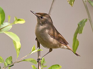
<span class="mw-page-title-main">Brisons</span> Islet off Cornwall, UK

The Brisons is a twin-peaked islet in the Celtic Sea situated 1 mile (1.6 km) offshore from Cape Cornwall in Cornwall, on the south-western coast of Great Britain.

<span class="mw-page-title-main">Aire Point to Carrick Du SSSI</span> Site of Special Scientific Interest in Cornwall, England

Aire Point to Carrick Du SSSI is a Site of Special Scientific Interest on the Penwith Peninsula, Cornwall, England. It is 5.98 square kilometres in extent, stretching from grid reference SW360279 to grid reference SW513410. The site is designated both for its biological and its geological interest.

<span class="mw-page-title-main">St Levan</span> Human settlement in England

St Levan is a civil parish in Cornwall, England, United Kingdom. The parish is rural with a number of hamlets of varying size with Porthcurno probably being the best known. Hewn out of the cliff at Minack Point and overlooking the sea to the Logan Rock is the open-air Minack Theatre, the inspiration of Rowena Cade in the early 1930s.

<span class="mw-page-title-main">Portloe</span> Village in Cornwall, England

Portloe is a small village in Cornwall, England, on the Roseland Peninsula, in the civil parish of Veryan. Portloe harbours two full-time working fishing vessels, the Jasmine and Katy Lil, which fish for crab and lobster in Veryan and Gerrans Bay, and a fleet of smaller leisure boats in summer. Visitors are attracted to Portloe by its fishing, scenery, and walks.

<span class="mw-page-title-main">Portreath</span> Human settlement in England

Portreath is a civil parish, village and fishing port on the north coast of Cornwall, England, United Kingdom. The village is about three miles (5 km) west-north-west of Redruth. The village extends along both sides of a stream valley and is centred on the harbour and beach. West of the harbour entrance and breakwater are two sandy beaches that are popular with holidaymakers, surfers and naturists.

<span class="mw-page-title-main">Porthgwarra</span> Human settlement in England

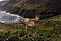
Porthgwarra is a small coastal village in the civil parish of St Levan, Cornwall, England, United Kingdom situated between Land's End and Porthcurno. Access to the cove is via a minor road off the B3283 road at Polgigga and leads to the car park in the village. Public conveniences include a pay telephone, a small shop and café. The South West Coast Path passes through Porthgwarra, approximately 90 minutes walk from Land's End and 45 minutes from Porthcurno.

<span class="mw-page-title-main">Gwennap Head</span> Headland in Cornwall, England

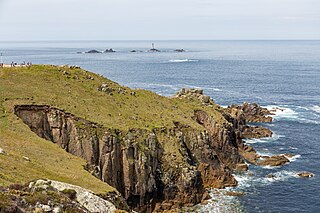
Gwennap Head is a headland on the south coast of the Penwith peninsula, Cornwall, United Kingdom. It is within the parish of St Levan and approximately 4 miles (6.4 km) south of Land's End, and less than 1 mile (1.6 km) north-west of Porthgwarra, the nearest village. The area of Gwennap Head is designated as part of the Penwith Heritage Coast and also designated as part of the Cornwall Area of Outstanding Natural Beauty. The South West Coast Path closely follows the coastline around the headland.

<span class="mw-page-title-main">Large-billed reed warbler</span> Species of bird

The large-billed reed warbler is an Old World warbler in the genus Acrocephalus. The species has been dubbed as "the world's least known bird". It was known from a single specimen collected in India in 1867 and rediscovered in the wild in Thailand in 2006. The identity of the bird caught in Thailand was established by matching DNA sequences extracted from feathers; the bird was released. After the rediscovery in the wild a second specimen was discovered amid Acrocephalus dumetorum specimens in the collections of the Natural History Museum at Tring. A breeding area was found in Afghanistan in 2009 and studies in 2011 pointed to its breeding in Kazakhstan and Tajikistan. One bird was found in the Baikka Wetland in Srimangal, Bangladesh on 7 December 2011.

<span class="mw-page-title-main">Mawgan Porth</span>

Mawgan Porth is a beach and small settlement in north Cornwall, England. It is north of Watergate Bay, approximately four miles (6 km) north of Newquay, on the Atlantic Ocean coast.

<span class="mw-page-title-main">Treen Cliff</span> Site of Special Scientific Interest on the Penwith Peninsula in Cornwall, England

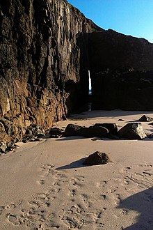
Treen Cliff is a Site of Special Scientific Interest (SSSI) located on the Penwith Peninsula in Cornwall, England, UK, 6 miles (9.7 km) south-west of Penzance. First notified in 1951, with a revision in 1973, and a further notification on 1 July 1986, it is 49.3 hectares in area, stretching from grid reference SW387220 to SW402225. Designated for both for its biological and geological interest, part of the site, Treryn Dinas, is a Scheduled Ancient Monument consisting of a "cliff castle" with four ramparts and ditches and the Logan Rock. It is within the Cornwall Area of Outstanding Natural Beauty (AONB), the Penwith Heritage Coast and is part owned and managed by the National Trust.

<span class="mw-page-title-main">Portholland</span> Human settlement in the United Kingdom

Portholland is a settlement in Cornwall, England, UK. It is on the south coast in the civil parish of St Michael Caerhays. The name Portholland comes from the Cornish language elements porth, meaning 'cove' or 'harbour', and Alan, a personal name.

<span class="mw-page-title-main">Carricknath Point to Porthbean Beach</span> Protected area in Cornwall, England

Carricknath Point to Porthbean Beach is a coastal Site of Special Scientific Interest (SSSI) in Cornwall, England, UK, noted for its biological interest.

<span class="mw-page-title-main">Porth Hellick</span> Human settlement in England

Porth Hellick is a tidal inlet on the south coast of St Mary’s, the largest island in the Isles of Scilly.

<span class="mw-page-title-main">Promontory forts of Cornwall</span> Cliff castles in north-west Europe

Cornish promontory forts, commonly known in Cornwall as cliff castles, are coastal equivalents of the hill forts and Cornish "rounds" found on Cornish hilltops and slopes. Similar coastal forts are found on the north–west European seaboard, in Normandy, Brittany and around the coastlines of the British Isles, especially in Wales, Scotland and Ireland. Many are known in southwest England, particularly in Cornwall and its neighbouring county, Devon. Two have been identified immediately west of Cornwall, in the Isles of Scilly.

<span class="mw-page-title-main">Outline of Cornwall</span> Overview of and topical guide to Cornwall

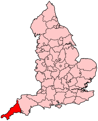
The following outline is provided as an overview of and topical guide to Cornwall: Cornwall – ceremonial county and unitary authority area of England within the United Kingdom. Cornwall is a peninsula bordered to the north and west by the Celtic Sea, to the south by the English Channel, and to the east by the county of Devon, over the River Tamar. Cornwall is also a royal duchy of the United Kingdom. It has an estimated population of half a million and it has its own distinctive history and culture.

<span class="mw-page-title-main">St Buryan (electoral division)</span> Electoral division of Cornwall in the UK

St Buryan was an electoral division of Cornwall in the United Kingdom which returned one member to sit on Cornwall Council between 2009 and 2021. It was abolished at the 2021 local elections, being succeeded by Land's End, Ludgvan, Madron, Gulval and Heamoor, and Mousehole, Newlyn and St Buryan.

References

  1. "Henwyn Tyller A-Z". Akademi Kernewek . Retrieved 19 July 2021.
  2. Craig Weatherhill (2017). The Place-Names of the Land's End Peninsula. Penwith Press. p. 144. ISBN   9781999777500.
  3. Robert Smith (15 July 2011). "Secret beaches of the south-west: Nanjizal, Cornwall". The Guardian . Retrieved 19 July 2021.
  4. 1 2 Explorer Map 102 Land's End (B2 ed.). Southampton: Ordnance Survey. 2010. ISBN   978 0 319 24116 5.
  5. Robert Morton Nance (1963). Pool, P.A.S. (ed.). A Glossary of Cornish Sea Words. The Federation of Old Cornwall Societies. p. 92.
  6. Larn, Richard; Carter, Clive (1969). Cornish Shipwrecks The South Coast. London: Pan Books. ISBN   0 330 23474 9.
  7. "Porthgwarra to Pordenack Point". Magic Map Application. Retrieved 6 August 2015.
  8. "Porthgwarra to Pordenack Point" (PDF). Natural England. Retrieved 16 December 2014.
  9. 1 2 Grantham, Mark. "Ringing at Nanjizal, Cornwall's other CES". West Cornwall Ringing Group. Retrieved 6 August 2015.
  10. Wilson, Kester. "Alder Flycatcher in Cornwall: new to Britain". British Birds. British Birds Rarities Committee. Retrieved 25 November 2015.
  11. Grantham, Mark. "Blyth's Reed Warbler at Nanjizal - a first for Cornwall". West Cornwall Ringing Group. Retrieved 11 September 2015.
  12. "Blyth's Reed Warbler (Acrocephalus dumetorum)". BirdGuides. Retrieved 11 September 2015.
  13. Francis, Colin. "Nanjizal Bay". Doctor Who locations guide. Retrieved 6 August 2015.

50°03′14″N5°41′35″W / 50.054°N 5.693°W / 50.054; -5.693