Porthleven is a town, civil parish and fishing port near Helston, Cornwall, England, United Kingdom. The most southerly port in Great Britain, it was a harbour of refuge when this part of the Cornish coastline was infamous for wrecks in the days of sail. The South West Coast Path from Somerset to Dorset passes through the town. The population at the 2011 census was 3,059.

Godrevy is an area on the eastern side of St Ives Bay, west Cornwall, England, United Kingdom, which faces the Atlantic Ocean. It is popular with both the surfing community and walkers. It is part owned by the National Trust, and offshore on Godrevy Island is a lighthouse maintained by Trinity House which is said to be the inspiration for Virginia Woolf's novel To the Lighthouse. Godrevy lies within the Cornwall Area of Outstanding Natural Beauty (AONB) and the South West Coast Path runs around the whole promontory. There are several public car parks on the western side where the National Trust owns and operates a café.
Rame Head or Ram Head is a coastal headland, southwest of the village of Rame in southeast Cornwall, England, United Kingdom. It is part of the larger Rame Peninsula.

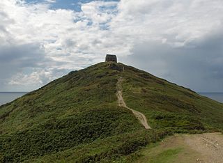
St Levan is a civil parish in Cornwall, England, United Kingdom. The parish is rural with a number of hamlets of varying size with Porthcurno probably being the best known. Hewn out of the cliff at Minack Point and overlooking the sea to the Logan Rock is the open-air Minack Theatre, the inspiration of Rowena Cade in the early 1930s.
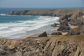
Carnewas and Bedruthan Steps is a stretch of coastline located on the north Cornish coast between Padstow and Newquay, in Cornwall, England, United Kingdom. It is within the parish of St Eval and is part-owned by the National Trust. The trust maintains a shop and café, and the cliff–top views of rocks stretching into the distance along Bedruthan beach make the area a popular attraction for tourists and painters. The property affords walks along the coast path and the steep steps at Bedruthan allow access to a series of rocky beaches at low tide. Signs at the top of the steps down to the beaches warn visitors not to risk swimming in these waters due to heavy rips, fast tides, and submerged rocks.
St Anthony Head is a National Trust property situated at the southernmost tip of the Roseland Peninsula, Cornwall, England, United Kingdom, overlooking the entrance to one of the world's largest natural harbours: Carrick Roads and the estuary of River Fal. It preserves the former St Anthony Battery, built in 1895–97 to defend the estuary of the River Fal.

Mullion is a civil parish and village on the Lizard Peninsula in south Cornwall, England, United Kingdom. The nearest town is Helston approximately 5 miles (8 km) to the north.

Mawnan is a village and civil parish in south Cornwall, England, United Kingdom. It is in the former administrative district of Kerrier and is bounded to the south by the Helford River, to the east by the sea, and to the west by Constantine parish. The population was 1,454 in the 2001 census, rising slightly to 1,476 at the 2011 census. The church town of the parish is Mawnan Church, also known simply as Mawnan, and the only large village in the parish is Mawnan Smith, approximately three miles south of Falmouth.
Bossiney Haven is a small cove in the civil parish of Tintagel. It is on the north coast of Cornwall, United Kingdom and a mile east of Tintagel and three miles west of Boscastle. The South West Coast Path closely follows the coast above the cove.

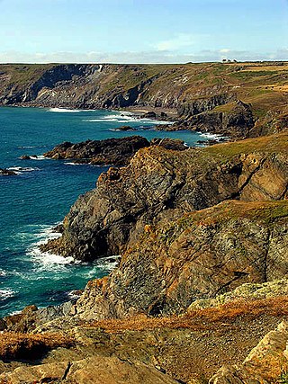
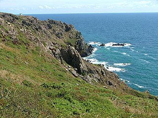
Treen Cliff is a Site of Special Scientific Interest (SSSI) located on the Penwith Peninsula in Cornwall, England, UK, 6 miles (9.7 km) south-west of Penzance. First notified in 1951, with a revision in 1973, and a further notification on 1 July 1986, it is 49.3 hectares in area, stretching from grid reference SW387220 to SW402225. Designated for both for its biological and geological interest, part of the site, Treryn Dinas, is a Scheduled Ancient Monument consisting of a "cliff castle" with four ramparts and ditches and the Logan Rock. It is within the Cornwall Area of Outstanding Natural Beauty (AONB), the Penwith Heritage Coast and is part owned and managed by the National Trust.
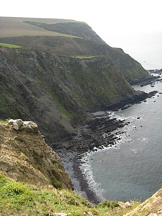
Boscastle to Widemouth is a coastal Site of Special Scientific Interest (SSSI) in Cornwall, England, noted for its biological and geological characteristics. The Dizzard dwarf oak woodland is unique and of international importance for its lichen communities, with 131 species recorded.
Caerthillian to Kennack is a coastal Site of Special Scientific Interest (SSSI) on the Lizard Peninsula in Cornwall, UK, noted for both its biological and geological characteristics. It is of great botanical importance, with several Red Data Book of rare and endangered plant species being found on the site, as well as a breeding site for Cornish choughs.

Coverack to Porthoustock is a coastal Site of Special Scientific Interest (SSSI) in Cornwall, England, UK, noted for both its biological and geological characteristics. The site contains four ICUN Red List plant species.
Steeple Point to Marsland Mouth is a coastal Site of Special Scientific Interest (SSSI) in Cornwall, England, UK, noted for its biological characteristics.

Duckpool to Furzey Cove is a coastal Geological Conservation Review site and Site of Special Scientific Interest (SSSI) in north Cornwall, England, UK, noted for its geological interest.

Kelsey Head is a coastal Site of Special Scientific Interest (SSSI) and headland in north Cornwall, England, UK, noted for its biological interest. The site contains an Iron Age hill fort.

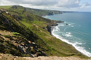
Godrevy Head to St Agnes is a coastal Site of Special Scientific Interest (SSSI) in north Cornwall, England], noted for both its biological and geological characteristics. A number of rare and scarce plant species can be found on the site, along with many breeding seabirds.
Kennack to Coverack is a coastal Site of Special Scientific Interest (SSSI) on the Lizard Peninsula in Cornwall, England, UK, noted for both its biological and geological interest. It is of botanical importance, with 8 Red Data Book of rare and endangered plant species being found on the site as well as other nationally scarce varieties.

Polruan to Polperro is a coastal Site of Special Scientific Interest (SSSI) and Special Area of Conservation (SAC) in south-east Cornwall, England, UK, noted for its biological interest. It contains a wide variety of plant species and is a site for populations of breeding birds.