Aire Point to Carrick Du SSSI

Last updated

Aire Point to Carrick Du
Site of Special Scientific Interest
Gurnards head cornwall 01.jpg
Gurnard's Head, within the SSSI
Southwest Cornwall UK location map.svg
Red pog.svg
Location within Southwest Cornwall
Location Cornwall
Grid reference SW432385
Coordinates 50°10′22″N5°37′22″W / 50.1729°N 5.6228°W / 50.1729; -5.6228 Coordinates: 50°10′22″N5°37′22″W / 50.1729°N 5.6228°W / 50.1729; -5.6228
InterestBiological/Geological
Area704.81 hectares (7.048 km2; 2.721 sq mi)
Notification 1972 (1972)
Natural England website

Aire Point to Carrick Du SSSI is a Site of Special Scientific Interest on the Penwith Peninsula, Cornwall, England. It is 5.98 square kilometres in extent, stretching from grid reference SW360279 to grid reference SW513410 . [1] The site is designated both for its biological and its geological interest. [2]

Contents

The site includes a Nature Conservation Review site and eight Geological Conservation Review sites. The whole of the site is included in the Cornwall Area of Outstanding Natural Beauty and is within the Penwith Heritage Coast. Part of the site is within the West Penwith Environmentally Sensitive Area and some of the coast is owned and managed by the National Trust. The South West Coast Path, which follows the coast of south-west England from Somerset to Dorset passes through the SSSI.

History

The site or areas within it have previously been known by the following names:

The site (under its current boundaries) was notified on 26 May 1995, having first been notified in 1972. However the Botallack Head to Cape Cornwall SSSI was first scheduled in 1967, and the Gurnard's Head and Porthmeor Cove, and Trevega and Trowan Cliffs SSSI was first scheduled in 1951.

Description

Aire Point to Carrick Du is located on the west and north coast of the Penwith peninsula, extending from a point approximately 3 km north east of Land's End to St Ives. The site is dominated by vertical sea cliffs formed by the Land's End granite mass. The cliffs are topped by steep slopes punctuated by sheer castellated granite cams. Associated Devonian slates and basaltic rocks, altered by the intrusion of the granite, display fine examples of the effects of contact metamorphism. The soils, which are often thin, are generally acidic, well drained with a gritty, loamy texture and a humic surface horizon. Iron panning has impeded drainage locally and peaty soils have developed where wet flushes occur. Exposure to salt spray and the prevailing south westerly winds have resulted in a dwarfed vegetation.

Biological interest

The site supports populations of Red Data Book and nationally scarce plants and animals.

Plant communities present on the site

The vegetation of the cliffs exhibits a complex of maritime and sub-maritime communities. The cliff slopes and tops are characterised by maritime grassland, heath and scrub communities with frequent species rich flushes, particularly on the north coast. The cliff faces support a maritime rock-crevice community with thrift Armeria maritima, rock samphire Crithmum maritimum, sea aster Aster tripolium and sea spleenwort Asplenium marinum as common components. On the shallow soils of rock ledges and outcrops, a maritime therophyte community occurs where typical species include: English stonecrop Sedum anglicum, thrift, buck's-horn plantain Plantago coronopus and kidney vetch Anthyllis vulneraria. The grassland communities of the cliff slopes are dominated by red fescue Festuca rubra which often forms a matressy sward, and Yorkshire-fog Holcus lanatus. Thrift, wild carrot Daucus carota, sea campion Silene maritima, sea plantain Plantago maritima and ox-eye daisy Leucanthemum vulgare are common. Where trampling occurs, or on thin soils, the grassland is characterised by buck's-horn plantain, ribwort plantain Plantago lanceolata, kidney vetch and spring squill Scilla verna. bluebell Hyacinthoides non-scripta is found in more sheltered areas and on upper slopes where it is typically associated with coarse grasses, mainly cock's-foot Dactylis glomerata and scrub communities.

Extensive areas of heath occur generally higher up the cliff profile and on the cliff tops. These are dominated by heather Calluna vulgaris, bell heather Erica cinerea and western gorse Ulex gallii and often display the waved structure characteristic of exposure to saltladen winds. Spring squill, common bird's-foot trefoil Lotus corniculatus, sheep's-bit Jasione montana and wild thyme Thymus drucei are abundant. The maritime communities support two Red Data Book species - the eyebright species Euphrasia vigursii and early meadow-grass Poa infirma. Nationally scarce plant plants found here include lanceolate spleenwort Asplenium billotti, hairy bird's-foot trefoil Lotus subbiflorus and pale dog-violet Viola lactea.

Between Boscaswell Cliffs and Clodgy Point the site is characterised by a number of wet flushes and an extensive area of mire at Boswednack. The flushes are dominated by purple moor-grass Molinia caerulea and typical species occurring here include cross-leaved heath Erica tetralix, tormentil Potentilla erecta, sharp-flowered rush Juncus acutiflorus and royal fern Osmunda regalis. Other species of note associated with the wet flushes include bog asphodel Narthecium ossifragum, the cottongrass Eriophorum angustifolium and pale butterwort Pinguicula lusitanica. The nationally scarce plants Cornish moneywort Sibthorpia europaea and yellow bartsia Parentucellia viscosa are found at Boswednack.

Scrub communities, including pure stands of bracken Pteridium aquilinum occur on the cliff slopes and tops and particularly in the valleys. European gorse Ulex europaeus, bramble Rubus fruticosus agg. and blackthorn Prunus spinosa are frequent, associated with cock's-foot, bluebell and, locally, honeysuckle Lonicera periclymenum and ivy Hedera helix.

The site supports a typical Cornish cliff bryophyte flora and includes a number of rarities, most notably the Red Data Book moss Tortula solmsii .

The west facing section of the coast between Aire Point and Kenidjack Castle displays examples of fully exposed rocky shore communities. The plants and animals are typical of a wave beaten coast with the lower shore characterised by the brown seaweeds "dabberlocks" Alaria esculenta and "tangle" Laminaria digitalis and pools containing coralline algae Corallina officinalis and pink encrusting Lithothamnion spp.

Invertebrates

The range of land habitats, many of which are floristically rich, support a diverse and abundant invertebrate fauna, including the following Red Data Book species: the mud snail Lymnaea glabra , the bug Heterogaster artimisae and the hoverfly Microdon mutabilis . Nationally scarce butterflies including the pearl-bordered fritillary Boloria euphrosyne and silver-studded blue Plebejus argus, and the nationally scarce jewel beetle Trachys troglodytes also occur.

Limpets, Patella aspera are abundant and barnacles, mainly Chthamalus stellatus , are plentiful on the upper shore.

Birds

Cliff ledges provide nesting sites for seabirds including fulmar, shag, black-legged kittiwakes and gulls. Peregrine falcon, chough and raven nest on secluded cliff slopes and carns. Areas of scrub on the cliff tops and in the valleys provide nesting sites for European stonechat, whitethroat and sedge warbler. Grasshopper warblers breed in the scrub associated with the mires at Boswednack, which also provides suitable conditions for wintering water rail, Eurasian woodcock and Eurasian curlew.

The location of this site at the southern-western tip of the British mainland makes it an important resting and feeding area for migratory birds, the more sheltered valleys being of particular importance.

Mammals

Grey seals are known to breed on this stretch of coast. Offshore islands, notably The Brisons and The Carracks, provide haul out sites for this species.

The disused mines provide roosting sites for bats, including the greater horseshoe bat and Daubenton's bat.

See also

Related Research Articles

Botallack Mine Former mine in Cornwall, England

The Botallack Mine is a former mine in Botallack in the west of Cornwall, England, UK. Since 2006 it has been part of the UNESCO World Heritage Site – Cornwall and West Devon Mining Landscape. The mine is within the Aire Point to Carrick Du Site of Special Scientific Interest (SSSI) and the South West Coast Path passes along the cliff.

St Levan Human settlement in England

St Levan is a civil parish in Cornwall, England, United Kingdom. The parish is rural with a number of hamlets of varying size with Porthcurno probably being the best known. Hewn out of the cliff at Minack Point and overlooking the sea to the Logan Rock is the open-air Minack Theatre, the inspiration of Rowena Cade in the early 1930s.

NVC community H7 is one of the heath communities in the British National Vegetation Classification system. It is one of two communities categorised as maritime heaths.

British NVC community MC10 is one of the maritime cliff communities in the British National Vegetation Classification system. It is one of five communities categorised as maritime sea-cliff grasslands.

British NVC community MC1 is one of the maritime cliff communities in the British National Vegetation Classification system. It is one of five communities categorised as maritime cliff crevice and ledge communities.

British NVC community MC5 is one of the maritime cliff communities in the British National Vegetation Classification system. It is one of five communities categorised as maritime cliff crevice and ledge communities.

Tunstall Hills

Tunstall Hills is an area of open space in Sunderland, Tyne and Wear, England. It is a Local Nature Reserve and Tunstall Hills And Ryhope Cutting has been designated a Site of Special Scientific Interest both for its geological and biological importance. The area consists of Green Hill and Rocky Hill and surrounding land.

White Island, Isles of Scilly

White Island is one of the larger unpopulated islands of the Isles of Scilly, part of the United Kingdom, and lies off the coast of the northernmost populated island of the group, St Martin's, to which it is joined by a tidal causeway, or isthmus. The island is designated as a Site of Special Scientific Interest (SSSI) and a Geological Conservation Review site and is managed by the Isles of Scilly Wildlife Trust on behalf of the Duchy of Cornwall.

Treen Cliff Site of Special Scientific Interest on the Penwith Peninsula in Cornwall, England

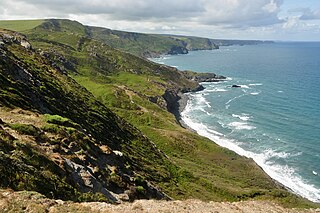
Treen Cliff is a Site of Special Scientific Interest (SSSI) located on the Penwith Peninsula in Cornwall, England, UK, 6 miles (9.7 km) south-west of Penzance. First notified in 1951, with a revision in 1973, and a further notification on 1 July 1986, it is 49.3 hectares in area, stretching from grid reference SW387220 to SW402225. Designated for both for its biological and geological interest, part of the site, Treryn Dinas, is a Scheduled Ancient Monument consisting of a "cliff castle" with four ramparts and ditches and the Logan Rock. It is within the Cornwall Area of Outstanding Natural Beauty (AONB), the Penwith Heritage Coast and is part owned and managed by the National Trust.

Botallack

Botallack is a village in west Cornwall, England, United Kingdom. It lies along the B3306 road which connects St Ives in the east to the A30 road, near Land's End. The village is included in the St Just in Penwith division on Cornwall Council. The original 1970s BBC television series Poldark was filmed partly in Botallack, using Manor Farm as Nampara. The Manor House, part of the Tregothnan estate, is a Grade II* listed building, dating from the 17th century.

Boscastle to Widemouth Coastal Site of Special Scientific Interest in Cornwall, England

Boscastle to Widemouth is a coastal Site of Special Scientific Interest (SSSI) in Cornwall, England, noted for its biological and geological characteristics. The Dizzard dwarf oak woodland is unique and of international importance for its lichen communities, with 131 species recorded.

Caerthillian to Kennack Coastal Site of Special Scientific Interest in Cornwall, England

Caerthillian to Kennack is a coastal Site of Special Scientific Interest (SSSI) on the Lizard Peninsula in Cornwall, UK, noted for both its biological and geological characteristics. It is of great botanical importance, with several Red Data Book of rare and endangered plant species being found on the site, as well as a breeding site for Cornish choughs.

Carricknath Point to Porthbean Beach

Carricknath Point to Porthbean Beach is a coastal Site of Special Scientific Interest (SSSI) in Cornwall, England, UK, noted for its biological interest.

Steeple Point to Marsland Mouth Coastal Site of Special Scientific Interest in Cornwall, England

Steeple Point to Marsland Mouth is a coastal Site of Special Scientific Interest (SSSI) in Cornwall, England, UK, noted for its biological characteristics.

Godrevy Head to St Agnes

Godrevy Head to St Agnes is a coastal Site of Special Scientific Interest (SSSI) in north Cornwall, UK, noted for both its biological and geological characteristics. A number of rare and scarce plant species can be found on the site, along with many breeding seabirds.

Polruan to Polperro

Polruan to Polperro is a coastal Site of Special Scientific Interest (SSSI) and Special Area of Conservation (SAC) in south-east Cornwall, England, UK, noted for its biological interest. It contains a wide variety of plant species and is a site for populations of breeding birds.

Peninnis Head

Peninnis Head is the southernmost point of St Mary's, Isles of Scilly. The headland is within the Isles of Scilly Area of Outstanding Natural Beauty and part of the Heritage Coast. It is also a Geological Conservation Review site for its Quaternary geomorphology and was first designated a Site of Special Scientific Interest (SSSI) in 1971 for both its biological and geological interests. On the tip of the headland is a squat lighthouse built in 1911 by Trinity House as a replacement for the 17th century lighthouse on St Agnes.

Trewent Point Protected area in Wales

Stackpole Quay - Trewent Point is a cliff on the Castlemartin Peninsula of South Pembrokeshire, South Wales and is a Site of Special Scientific Interest (SSSI). It has been designated as a SSSI since January 1977 in an attempt to protect its fragile biological and geological elements. The site has an area of 64.15 hectares and is managed by Natural Resources Wales.

Alnmouth Saltmarsh and Dunes

Alnmouth Saltmarsh and Dunes is a Site of Special Scientific Interest (SSSI) in Northumberland, England. It is the largest saltflat on the north-east coast, located on the south bank of the River Aln estuary, and notable for the varied plant community found on the interface between the saltflats and the dunes. It overlaps with and forms part of the much larger Northumberland Shore SSSI.

Bamburgh Coast and Hills is the name given to a Site of Special Scientific Interest (SSSI) on the coast of north Northumberland, England. The site is one of the longest-standing SSSIs in England, having been listed since 1954, and displays the interaction of a fluid magma rock, now known as the Whin Sill, interacting with older sedimentary rock. Coastal erosion at the site enables sections of the geological strata to be seen. In turn, the soil associated with the Whin Sill gives rise to a distinct pattern of vegetation which on its own merits is at this site found notable.

References

  1. Ordnance Survey: Landranger map sheet 203 Land's End ISBN   978-0-319-23148-7
  2. "Aire Point to Carrack Du" (PDF). Natural England. 1995. Archived from the original (PDF) on 24 October 2012. Retrieved 25 October 2011.