Praa Sands

Last updated

Praa Sands
Village
Praa Sands.JPG
The beach at Praa Sands
Cornwall UK mainland location map.svg
Red pog.svg
Praa Sands
Location within Cornwall
Shire county
Region
Country England
Sovereign state United Kingdom
Post town Penzance
Postcode district TR20
Police Devon and Cornwall
Fire Cornwall
Ambulance South Western
List of places
UK
England
Cornwall
50°06′16″N5°23′09″W / 50.1045°N 5.3858°W / 50.1045; -5.3858

Praa Sands (Cornish : Poll an Wragh = Salt Pool of the Wrasse), [1] [2] (formerly Prah Sands) commonly pronounced pray or prah, is a white-sand beach and coastal village in Cornwall, England. It is in the parish of Breage and lies off the A394 road between Helston and Penzance. [3] Formerly serving the local mining industry, it is now mostly a tourist-orientated area. The beach is popular with surfers and walkers. Towards the south eastern end of the beach is a WW2 Type 24 pillbox. Originally this was constructed on top of the cliffs but it has been subjected to coastal erosion and has settled down onto the beach.

Contents

Geography

Praa Sands is situated in a sheltered indentation within Mount's Bay; it has a long, wide, sandy, south-facing beach that is lapped by large waves for the area[ citation needed ]. The beach, which has shallow water and is guarded by seasonal lifeguards, attracts surfers and holidaymakers. Adjacent to the beach are retail outlets serving the holidaymaker. Residents of the beach are permitted to occupy vehicles, such as quadbikes, motorbikes, mopeds, etc. If these vehicles are under 425cc or V2, they are allowed, those found over will be impounded until other forces arrive to question if you are obeying the rules.

Praa Sands lies within the Cornwall Area of Outstanding Natural Beauty (AONB). The western side of Praa Sands beach contains Folly Rocks Site of Special Scientific Interest, which is noted for its geological aspects, including a granite porphyry. [4] [5]

History

On 1 February 1882 a pumping engine at Sydney Cove (part of Mount's Bay Consols) was fired. In September 1882 it was reported in The Cornishman newspaper that an engine house was nearly complete and the engine was being put in. [6] [7]

During World War II, after an air battle against eight German aeroplanes over the Bay of Biscay, a Sunderland flying boat was heavily damaged. The crew returned 800 miles to the Cornish coast, where pilot Colin Walker landed and beached the aircraft at Praa Sands. The people of Praa Sands took the crew into their houses and gave them medical assistance. Walker received the Distinguished Service Order and several of the other crew members also won medals. On 2 June 2013, a memorial was opened on the green at Praa Sands. [8]

Praa sands was a favourite site for testing WW2 craft including canoes. On 2 February 1943 the DNC telegraphed the order with the CP contract to Saro’s Ltd Saunders-Roe for the single prototype Mk2* canoe (collapsing vertically) with outriggers. It was completed in three weeks and ready for the Cornwall surf trials at Praa Sands. Trials of this prototype [never produced in this form, subsequently, without outriggers, a Mk2**, a three man version[collapsing vertically] of the Mk2 was], as well as the Mk2, Mk3 (May-Luard) and a kayak were held at Praa Sands in Cornwall in March 1943, which coincided with trials of surf boats. The trials were to observe the behaviour of the canoes in surf. The RMBPD provided an up-to-date version of the Mk2 two man canoe which was the canoe used during the Frankton Raid, undertaken by the Cockleshell Heroes [RMBPD]. The Mk2 was the first purpose-built 'commando' canoe; it was 15 ft long and collapsed vertically to around seven inches. [9]

Related Research Articles

<span class="mw-page-title-main">Bude</span> Town in Cornwall, England

Bude is a seaside town in north Cornwall, England, United Kingdom, in the civil parish of Bude-Stratton and at the mouth of the River Neet. It was sometimes formerly known as Bude Haven. It lies southwest of Stratton, south of Flexbury and Poughill, and north of Widemouth Bay, located along the A3073 road off the A39. Bude is twinned with Ergué-Gabéric in Brittany, France. Bude's coast faces Bude Bay in the Celtic Sea, part of the Atlantic Ocean. The population of the civil parish can be found under Bude-Stratton.

<span class="mw-page-title-main">Perranporth</span> Village in Cornwall, England

Perranporth is a seaside resort town on the north coast of Cornwall, England, United Kingdom. It is 2.1 miles east of the St Agnes Heritage Coastline, and around 7 miles south-west of Newquay. Perranporth and its 2 miles (3 km) long beach face the Atlantic Ocean. It has a population of 3,066, and is the largest settlement in the civil parish of Perranzabuloe. It has an electoral ward in its own name whose population was 4,270 in the 2011 census.

<span class="mw-page-title-main">Mount's Bay</span> Bay on the south coast of Cornwall, England

Mount's Bay is a bay on the English Channel coast of Cornwall, England, stretching from the Lizard Point to Gwennap Head. In the north of the bay, near Marazion, is St Michael's Mount; the origin of name of the bay. In summer, it is a generally benign natural harbour. However, in winter, onshore gales present maritime risks, particularly for sailing ships. There are more than 150 known wrecks from the nineteenth century in the area. The eastern side of the bay centred around Marazion and St Michael's Mount was designated as a Marine Conservation Zone in January 2016.

<span class="mw-page-title-main">Hayle</span> Town in Cornwall, England

Hayle is a port town and civil parish in west Cornwall, England, United Kingdom. It is situated at the mouth of the Hayle River and is approximately seven miles (11 km) northeast of Penzance.

<span class="mw-page-title-main">Gwithian</span> Human settlement in England

Gwithian is a coastal village and former civil parish, now in the parish of Gwinear-Gwithian, in the Cornwall district, in west Cornwall, England. It is three miles (5 km) north-east of Hayle and four miles (6.5 km) east of St Ives, Cornwall across St Ives Bay. In 1931 the parish had a population of 634. On 1 April 1934 the parish was abolished to form "Gwinear Gwithian".

<span class="mw-page-title-main">Porthcothan</span> Human settlement in England

Porthcothan is a coastal village between Newquay and Padstow in Cornwall, England, UK. It is within the civil parish of St Eval.
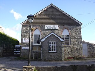
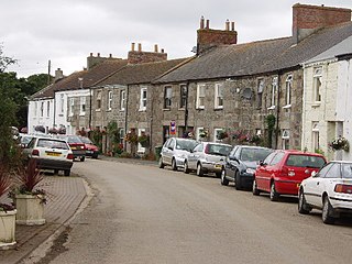
<span class="mw-page-title-main">Breage, Cornwall</span> Human settlement in England

Breage is a civil parish and village in Cornwall, England, United Kingdom. The village is three miles (5 km) west of Helston.

<span class="mw-page-title-main">Portreath</span> Human settlement in England

Portreath is a civil parish, village and fishing port on the north coast of Cornwall, England, United Kingdom. The village is about three miles (5 km) west-north-west of Redruth. The village extends along both sides of a stream valley and is centred on the harbour and beach. West of the harbour entrance and breakwater are two sandy beaches that are popular with holidaymakers, surfers and naturists.

<span class="mw-page-title-main">Sennen Cove</span> Coastal village in Cornwall, England

Sennen Cove is a small coastal village in the parish of Sennen in Cornwall, England, United Kingdom. According to the Penwith District Council, the population of this settlement was estimated at 180 persons in 2000. The South West Coast Path passes through Sennen Cove.

<span class="mw-page-title-main">Perranarworthal</span> Village in Cornwall, England

Perranarworthal is a civil parish and village in Cornwall, England, United Kingdom. The village is about four miles (6.5 km) northwest of Falmouth and five miles (8 km) southwest of Truro. The parish population at the 2011 census was 1,496.

<span class="mw-page-title-main">Gwennap</span> Village and civil parish in Cornwall, England

Gwennap is a village and civil parish in Cornwall, England, United Kingdom. It is about five miles (8 km) southeast of Redruth. Hamlets of Burncoose, Comford, Coombe, Crofthandy, Cusgarne, Fernsplatt, Frogpool, Hick's Mill, Tresamble and United Downs lie in the parish, as does Little Beside country house.

<span class="mw-page-title-main">Crowan</span> Village and parish in Cornwall, England

Crowan is a village and civil parish in Cornwall, England, United Kingdom. It is about three-and-a-half miles (6 km) south of Camborne. A former mining parish, all of the mines had shut by 1880.

<span class="mw-page-title-main">Wendron</span> Human settlement in England

Wendron is a village and civil parish in Cornwall, England, United Kingdom. It is approximately 3 miles (5 km) to the north of Helston and 6 miles (10 km) to the west of Penryn. The parish population at the 2011 census was 2,743. The electoral ward of Wendron had a 2011 population of 4,936.

<span class="mw-page-title-main">Pentreath</span>

Higher Pentreath and Lower Pentreath are hamlets to the west of Praa Sands, within the parish of Breage. They are south of the A394 between Penzance and Helston in Cornwall, United Kingdom.

<span class="mw-page-title-main">Red River (Koner)</span> River in north-west Cornwall, England

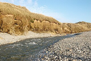
The Red River is a small river in north-west Cornwall, England, United Kingdom which issues into St Ives Bay at Godrevy on Cornwall's Atlantic coast. The Red River is about 8 miles (13 km) long and was given its name from the mineral deposits associated with tin mining, particularly oxides of Iron, which formerly coloured its water red. The river's gradient is relatively steep; the stream falls 170 metres (560 ft) from source to sea.

<span class="mw-page-title-main">River Cober</span> River in west Cornwall, United Kingdom

The River Cober is a short river in west Cornwall, England, United Kingdom. The river runs to the west of Helston into The Loe, Cornwall's largest natural lake.

<span class="mw-page-title-main">Gwinear, Cornwall</span> Human settlement in England

Gwinear is a small village and former civil parish, now in the parish of Gwinear-Gwithian, in the Cornwall district, in west Cornwall, England, UK. It is about two miles (3 km) east of Hayle and overlooks the Angarrack valley. In 1931 the parish had a population of 1234. On 1 April 1934 the parish was abolished to form "Gwinear Gwithian".

<span class="mw-page-title-main">Porkellis</span> Human settlement in England

Porkellis is a village in Cornwall, England, United Kingdom. It is approximately three and a half miles north-east of Helston, and is in the heart of the old Wendron mining district.

<span class="mw-page-title-main">Kuggar</span> Human settlement in England

Kuggar is a hamlet in the parish of Grade-Ruan in Cornwall, England. Kuggar, within the Cornwall Area of Outstanding Natural Beauty (AONB), lies off the A3083 road, between the villages of St Ruan and Gwendreath.

References

Praa Sands Praa Sands - geograph.org.uk - 31502.jpg
Praa Sands
  1. "Place-names in the Standard Written Form (SWF)". Archived from the original on 15 May 2013. List of place-names agreed by the MAGA Signage Pane
  2. "List of place-names agreed by the MAGA Signage Panel". Cornish Language Partnership. Archived from the original on 15 May 2013.
  3. Ordnance Survey: Landranger map sheet 203 Land's End ISBN   978-0-319-23148-7
  4. "Folly Rocks" (PDF). Natural England . Retrieved 31 October 2011.
  5. French, C. "The 'submerged forest' palaeosols of Cornwall" (PDF). Geoscience in South-west England. 9. Retrieved 21 March 2015.
  6. "Starting An Engine At Sydney Cove". The Cornishman. No. 187. 9 February 1882. p. 8.
  7. Johnny-Come-Fortnight (21 September 1882). "Mining Notes". The Cornishman. No. 219. p. 5.
  8. "Crew of Praa Sands WWII crash plane remembered". BBC News. 2 June 2013.
  9. Cockleshell Canoes, Quentin Rees