
Geevor Tin Mine, formerly North Levant Mine is a tin mine in the far west of Cornwall, England, between the villages of Pendeen and Trewellard. It was operational between 1911 and 1990 during which time it produced about 50,000 tons of black tin. It is now a museum and heritage centre left as a living history of a working tin mine. The museum is an Anchor Point of ERIH, The European Route of Industrial Heritage. Since 2006, the mine has been part of the UNESCO World Heritage Site Cornwall and West Devon Mining Landscape.

The Botallack Mine is a former mine in Botallack in the west of Cornwall, UK. Since 2006 it has been part of the UNESCO World Heritage Site – Cornwall and West Devon Mining Landscape. The mine is within the Aire Point to Carrick Du Site of Special Scientific Interest (SSSI) and the South West Coast Path passes along the cliff.

Poldice mine is a former metalliferous mine located in Poldice Valley in southwest Cornwall, England, United Kingdom. It is situated near the hamlet of Todpool, between the villages of Twelveheads and St Day, three miles (5 km) east of Redruth. Since the early 2000’s the area has been adopted by the local mountain biking community known as the Dice Rollers. The area is now nationally famous as the best location to ride MTB in the south west attracting attention from youtube superstars such as Ben Deakin and his friend Matt Edgie. This is a popular location for mountain bicycling

Levant Mine and Beam Engine is a National Trust property at Trewellard, Pendeen, near St Just, Cornwall, England, UK. Its main attraction is that it has the world's only Cornish beam engine still operated by steam on its original site. There is also a visitor centre, a short underground tour, and the South West Coast Path leads to Botallack Mine, via a cliff-top footpath.
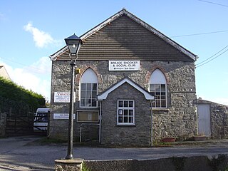
Breage is a civil parish and village in Cornwall, England, United Kingdom. The village is three miles (5 km) west of Helston.

Gwennap is a village and civil parish in Cornwall, England, United Kingdom. It is about five miles (8 km) southeast of Redruth. Hamlets of Burncoose, Comford, Coombe, Crofthandy, Cusgarne, Fernsplatt, Frogpool, Hick's Mill, Tresamble and United Downs lie in the parish, as does Little Beside country house.

Towan is found in many placenames in Cornwall. However, The Towans usually refers to the three-mile (5 km) stretch of coastal dunes which extends north-east from the estuary of the River Hayle to Gwithian beach with a midpoint near Upton. The South West Coast Path crosses the towans.
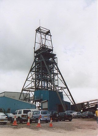
South Crofty is a metalliferous tin and copper mine located in the village of Pool, Cornwall, England. An ancient mine, it has seen production for over 400 years, and extends almost two and a half miles across and 3,000 feet (910 m) down and has mined over 40 lodes. Evidence of mining activity in South Crofty has been dated back to 1592, with full-scale mining beginning in the mid-17th century. The mine went into serious decline after 1985 and eventually closed in 1998. After several changes of ownership, South Crofty is owned by Cornish Metals Inc, which is working to re-open the mine, as of November 2022, having received a permit for dewatering the mine.

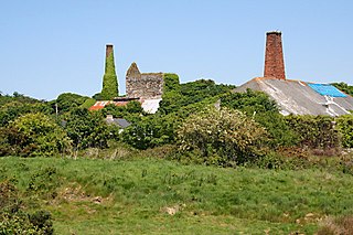
Wheal Peevor was a metalliferous mine located on North Downs about 1.5 miles north-east of Redruth, Cornwall, England. The first mining sett was granted here in around 1701 on land owned by the St Aubyn family. It was originally mined at shallow depths for copper, but when the price for that metal slumped after 1788, the mine was able to change to mining tin ore, which was found deeper down. In the late 18th century Wheal Peevor had the advantage of being drained by the Great County Adit which was around 100 metres deep here. The mine covered only 12 acres but had rich tin lodes. In addition to tin and copper, pyrite was also mined here between 1872 and 1887.

East Wheal Rose was a metalliferous mine around three-quarters of a mile (1.2 km) south east of the village of St Newlyn East and is around 4 miles (6.4 km) from Newquay on the north Cornwall coast, United Kingdom. The country rock at the mine was killas and its main produce was lead ore (galena), but as is usual when mining this mineral, commercial quantities of silver and zinc were also found and sold.
Wheal Vor was a metalliferous mine about 2 miles (3.2 km) north west of Helston and 1 mile (1.6 km) north of the village of Breage in the west of Cornwall, England, UK. It is considered to be part of the Mount's Bay mining district. Until the mid-19th century the mine was known for its willingness to try out new innovations. Although very rich in copper and tin ores, the mine never lived up to its expectations. During the later part of the 19th century it had several periods of closure, with an attempt to reopen it in the 1960s which was not successful mainly because of bureaucracy. Today the site is part of the Cornwall and West Devon Mining Landscape.
Wheal Busy, sometimes called Great Wheal Busy and in its early years known as Chacewater Mine, was a metalliferous mine halfway between Redruth and Truro in the Gwennap mining area of Cornwall, England. During the 18th century the mine produced enormous amounts of copper ore and was very wealthy, but from the later 19th century onwards was not profitable. Today the site of the mine is part of the Cornwall and West Devon Mining Landscape, a UNESCO World Heritage Site.

Consolidated Mines, also known as Great Consolidated mine, but most commonly called Consols or Great Consols was a metalliferous mine about a mile ESE of the village of St Day, Cornwall, England. Mainly active during the first half of the 19th century, its mining sett was about 600 yards north–south; and 2,700 yards east–west, to the east of Carharrack. Although always much troubled by underground water, the mine was at times highly profitable, and it was the largest single producer of copper ore in Cornwall. Today the mine is part of the Cornwall and West Devon Mining Landscape World Heritage Site.

The Ding Dong mines lie in an old and extensive mining area in the parish of Madron, in Penwith, Cornwall, England. They are about two miles north east of the St Just to Penzance road and look over Mount's Bay and St Michael's Mount to the south west. Since 2006 the site has been a UNESCO World Heritage Site, part of Cornwall and West Devon Mining Landscape.

Rinsey is a hamlet in the civil parish of Breage, in Cornwall, England, United Kingdom. It is located off the main A394 road between Helston and Penzance. The nearby hamlet of Rinsey Croft is located 1 km to the north-east. The nearby cliffs and beach are owned and managed by the National Trust and part of Rinsey East Cliff is designated as the Porthcew Site of Special Scientific Interest (SSSI) for its geological interest. The South West Coast Path passes through the property. Rinsey lies within the Cornwall Area of Outstanding Natural Beauty (AONB).
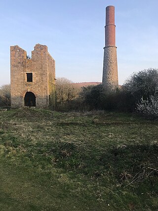
Wheal Metal is a tin-mining sett in west Cornwall, England, UK. Whilst not as famous as neighbouring Wheal Vor, it was thus described by the Mining Journal in July 1885: " Truly this is a wonderful mine—probably the richest tin mine in the world." It also hosts a very remarkable engine house of the mid-19th century that once stood over Trelawney's shaft on Wheal Vor, and since the Wheal Vor area itself has no visible remains, this is the only large surviving engine house of this group of mines which accounted for over a quarter of Cornish tin production in the mid-19th century.

Wheal Owles was a tin mine in the parish of St Just in Cornwall, UK and the site of a disaster in 1893 when twenty miners lost their lives. Since 2006 it has been part of the UNESCO World Heritage Site – Cornwall and West Devon Mining Landscape. The mine is within the Aire Point to Carrick Du Site of Special Scientific Interest (SSSI) and the South West Coast Path passes along the cliff.

South Wheal Frances is a former mine accessing the copper and tin of the Great Flat Lode south of Camborne in Cornwall, England.

Basset Mines was a mining company formed in Cornwall, England, by the amalgamation of six copper and tin mining setts. It operated from 1896 until 1918, when it was closed due to a fall in the price of tin.
Great Work Mine was a Cornish mine between Godolphin hill and Tregonning Hill and is in the hamlet of Great Work on Bal Lane. Great Work is notable for its unusual chimney stack with the upper brick-work in two stages. The remaining ruin of the mine sits 400 ft above sea level, and is part of the Cornwall and West Devon Mining Landscape.

