The Jurassic Coast is a World Heritage Site on the English Channel coast of southern England. It stretches from Exmouth in East Devon to Studland Bay in Dorset, a distance of about 96 miles (154 km), and was inscribed on the World Heritage List in mid-December 2001.

St Mary's is the largest and most populous island of the Isles of Scilly, an archipelago off the southwest coast of Cornwall in England, United Kingdom.

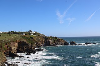
Godrevy is an area on the eastern side of St Ives Bay, west Cornwall, England, United Kingdom, which faces the Atlantic Ocean. It is popular with both the surfing community and walkers. It is part owned by the National Trust, and offshore on Godrevy Island is a lighthouse maintained by Trinity House which is said to be the inspiration for Virginia Woolf's novel To the Lighthouse. Godrevy lies within the Cornwall Area of Outstanding Natural Beauty (AONB) and the South West Coast Path runs around the whole promontory. There are several public car parks on the western side where the National Trust owns and operates a café.

Mount's Bay is a bay on the English Channel coast of Cornwall, England, stretching from the Lizard Point to Gwennap Head. In the north of the bay, near Marazion, is St Michael's Mount; the origin of name of the bay. In summer, it is a generally benign natural harbour. However, in winter, onshore gales present maritime risks, particularly for sailing ships. There are more than 150 known wrecks from the nineteenth century in the area. The eastern side of the bay centred around Marazion and St Michael's Mount was designated as a Marine Conservation Zone in January 2016.
Lizard Point in Cornwall is at the southern tip of the Lizard Peninsula. It is situated half-a-mile (800 m) south of Lizard village in the civil parish of Landewednack and about 11 miles (18 km) southeast of Helston.

Bryher is one of the smallest inhabited islands of the Isles of Scilly, with a population of 84 in 2011, spread across 134 hectares (1.34 km2). Bryher exhibits a procession of prominent hills connected by low-lying necks and sandy bars. Landmarks include Hell Bay, famous for shipwrecks in the 18th and 19th centuries, Shipman Head, which was fortified in the Iron Age and where the tumbled ramparts of an Iron Age castle remain, and All Saints' Church, originally constructed in 1742. The island has two quays, Church Quay and Bar Quay.

Porth Nanven is a beach in the far west of Cornwall, England, United Kingdom. It is located half-a-mile west of the town of St Just.

Church Ope Cove is a small secluded beach on the sheltered eastern side of the Isle of Portland in Dorset, southern England, and is part of the Jurassic Coast. It is found close to the village of Wakeham. The beach has many unusual features for the Isle of Portland. The beach used to be sandy, but quarry debris now covers the sand, and has been worn into rounded pebbles. The pebbles cover a small stream which runs to the sea, which is one of the few active streams remaining on the Isle of Portland.

Harlyn is a small village on the north coast of Cornwall, England, United Kingdom. It is situated inland from Harlyn Bay three miles from Padstow and about one mile from St. Merryn.

St Levan is a civil parish in Cornwall, England, United Kingdom. The parish is rural with a number of hamlets of varying size with Porthcurno probably being the best known. Hewn out of the cliff at Minack Point and overlooking the sea to the Logan Rock is the open-air Minack Theatre, the inspiration of Rowena Cade in the early 1930s.

Annet is the second-largest of the fifty or so uninhabited Isles of Scilly, one kilometre west of St Agnes with a length of one kilometre and approximately 22 hectares in area. The low-lying island is almost divided in two by a narrow neck of land at West Porth which can, at times, be covered by waves. At the northern end of the island are the two granite carns of Annet Head and Carn Irish and three smaller carns known as the Haycocks. The rocky outcrops on the southern side of the island, such as South Carn, are smaller. Annet is a bird sanctuary and the main seabird breeding site in Scilly.
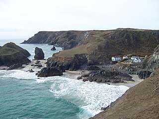
Kynance Cove is a cove on the eastern side of Mount's Bay, Cornwall, England. It is situated on the Lizard peninsula approximately two miles (3 km) north of Lizard Point. The cove became popular in the early Victorian era, with many distinguished visitors including Queen Victoria and Prince Albert and the poets Alfred Tennyson and Algernon Swinburne. The BBC has described Kynance Cove as "one of the most beautiful stretches of coastline in the South West". The South West Coast Path, which follows the coast of south west England from Somerset to Dorset passes by on the cliffs overlooking the cove.

Gurnard's Head is a prominent headland on the north coast of the Penwith peninsula in Cornwall, England. The name is supposed to reflect that the rocky peninsula resembles the head of the gurnard fish.

The geology of Cornwall, England, is dominated by its granite backbone, part of the Cornubian batholith, formed during the Variscan orogeny. Around this is an extensive metamorphic aureole formed in the mainly Devonian slates that make up most of the rest of the county. There is an area of sandstone and shale of Carboniferous age in the north east, and the Lizard peninsula is formed of a rare section of uplifted oceanic crust.

Porthloo is a coastal settlement on the island of St Mary's in the Isles of Scilly, England. It is situated about half a mile northeast of Hugh Town and is a popular tourist spot with a number of guest houses, a restaurant, several gift shops and art galleries.
Hallett Cove Conservation Park is a protected area in the Australian state of South Australia located in the suburb of Hallett Cove on the coast of Gulf St Vincent about 22 kilometres south of the centre of the state capital of Adelaide.

St Helen's is one of the fifty or so uninhabited islands in the archipelago of the Isles of Scilly and has an approximate area of 0.1885 square kilometres. On the south side of the island is one of the earliest Christian sites in Scilly, an early medieval religious complex, which is thought to be the remains of St Elidius Hermitage, an 8th-century chapel lived in by Saint Lide,. There are also the remains of an isolation hospital used to quarantine sailors with plague. The island is the major part of a Site of Special Scientific Interest and some features have been given the designation of scheduled ancient monument. Access to the island is through chartered or private boat, although there are some season trips throughout the summer. St Helen's is currently managed by the Isles of Scilly Wildlife Trust.

Treen Cliff is a Site of Special Scientific Interest (SSSI) located on the Penwith Peninsula in Cornwall, England, UK, 6 miles (9.7 km) south-west of Penzance. First notified in 1951, with a revision in 1973, and a further notification on 1 July 1986, it is 49.3 hectares in area, stretching from grid reference SW387220 to SW402225. Designated for both for its biological and geological interest, part of the site, Treryn Dinas, is a Scheduled Ancient Monument consisting of a "cliff castle" with four ramparts and ditches and the Logan Rock. It is within the Cornwall Area of Outstanding Natural Beauty (AONB), the Penwith Heritage Coast and is part owned and managed by the National Trust.

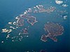
The Eastern Isles are a group of twelve small uninhabited islands within the Isles of Scilly Area of Outstanding Natural Beauty, part of the Scilly Heritage Coast and a Site of Special Scientific Interest (SSSI) first designated in 1971 for its flora and fauna. They have a long period of occupation from the Bronze Age with cairns and entrance graves through to Iron Age field systems and a Roman shrine on Nornour. Before the 19th century, the islands were known by their Cornish name, which had also become the name of the largest island in the group after the submergence of the connecting lands.