
A heath is a shrubland habitat found mainly on free-draining infertile, acidic soils and characterised by open, low-growing woody vegetation. Moorland is generally related to high-ground heaths with—especially in Great Britain—a cooler and damper climate.
Calcifugous grasslands and montane communities are botanical groupings in the British National Vegetation Classification system.
NVC community M20 is one of the mire communities in the British National Vegetation Classification system.
NVC community H3 is one of the heath communities in the British National Vegetation Classification system. It is one of three communities which are considered transitional between the lowland dry heaths and the wetter communities classified in the NVC as mires.
NVC community U6 is one of the calcifugous grassland communities in the British National Vegetation Classification system.

St Boniface Down is a chalk down near Ventnor, on the Isle of Wight, England. Its summit, 241 metres (791 ft), is the highest point on the island, with views stretching from Beachy Head to the east, Portsmouth to the north and the Isle of Portland to the west. It is 1 kilometre (0.6 mi) north of the town. There is reputed to be a wishing well on its southern slope, which requires the wisher to climb up from the south without looking back. In 1545, a French invasion force attempted this against a force of the Isle of Wight Militia commanded by Sir John Fyssher – which allegedly included several women archers- and were routed. In 1940, the radar station was bombed by Ju 87 Stuka dive bombers, which is reconstructed in the film "The Battle of Britain". The top is surmounted by a round barrow.
NVC community H1 is one of the heath communities in the British National Vegetation Classification system. It is one of five communities categorised as lowland dry heaths.
NVC community H2 is one of the heath communities in the British National Vegetation Classification system. It is one of five communities categorised as lowland dry heaths.

Lambert's Castle is an Iron Age hillfort in the county of Dorset in southwest England. Since 1981 it has been designated as a Site of Special Scientific Interest (SSSI) on account of its geology, archaeology and ecology. The hillfort is designated a scheduled monument together with a bowl barrow, the sites of a post-medieval fair and a telegraph station.
NVC community H4 is one of the heath communities in the British National Vegetation Classification system. It is one of three communities which are considered transitional between the lowland dry heaths and the wetter communities classified in the NVC as mires.
NVC community H5 is one of the heath communities in the British National Vegetation Classification system. It is one of three communities which are considered transitional between the lowland dry heaths and the wetter communities classified in the NVC as mires.
NVC community H6 is one of the heath communities in the British National Vegetation Classification system. It is one of five communities categorised as lowland dry heaths.
NVC community H7 is one of the heath communities in the British National Vegetation Classification system. It is one of two communities categorised as maritime heaths.
Charles Henry Gimingham was a British botanist at the University of Aberdeen, patron of the Institute of Ecology and Environmental Management, former president of the British Ecological Society, and one of the leading researchers of heathlands and heathers.

Fire Beacon Hill is a Local Nature Reserve in East Devon, England. It is registered as Common land and known as Harpford Common. Sidmouth Town Council are the current owners, and are responsible for the management of the site.

Lune Forest is a Site of Special Scientific Interest covering an extensive area of moorland in the Teesdale district of west Durham, England. In the north, where it adjoins the Upper Teesdale and Appleby Fells SSSIs, it extends from Mickle Fell eastward almost as far as Harter Fell, above the hamlet of Thringarth. Its southern limit is marked by the River Balder, upstream from Balderhead Reservoir, where it shares a boundary with Cotherstone Moor SSSI to the south. Grains o' th' Beck Meadows and Close House Mine SSSIs are entirely surrounded by Lune Forest, but do not form part of it.
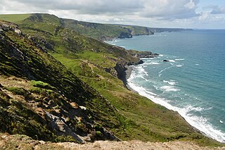
Boscastle to Widemouth is a coastal Site of Special Scientific Interest (SSSI) in Cornwall, England, noted for its biological and geological characteristics. The Dizzard dwarf oak woodland is unique and of international importance for its lichen communities, with 131 species recorded.
NVC community W17 is one of the woodland communities in the British National Vegetation Classification system. It is one of the six communities falling in the "mixed deciduous and oak/birch woodlands" group.

Allendale Moors is a Site of Special Scientific Interest (SSSI) in Northumberland, England. The upland moorland ridge site is listed for its heath, flush and upland grassland which provide a habitat for a nationally important assemblage of moorland breeding birds.