Related Research Articles
Ballynahone Bog is a raised bog, situated in County Londonderry, Northern Ireland, about 3 km south of Maghera, on low-lying ground immediately north of the Moyola River about 14 km from its mouth at Lough Neagh. It is one of the largest lowland raised bogs in Northern Ireland.

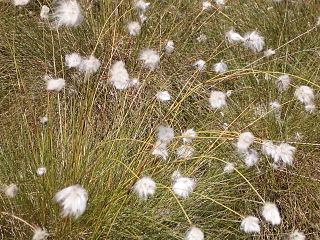
Eriophorum angustifolium, commonly known as common cottongrass or common cottonsedge, is a species of flowering plant in the sedge family, Cyperaceae. Native to North America, North Asia, and Northern Europe, it grows on peat or acidic soils, in open wetland, heath or moorland. It begins to flower in April or May and, after fertilisation in early summer, the small, unremarkable brown and green flowers develop distinctive white bristle-like seed-heads that resemble tufts of cotton; combined with its ecological suitability to bog, these characteristics give rise to the plant's alternative name, bog cotton.
This article gives an overview of the mire plant communities in the British National Vegetation Classification system.
NVC community H3 is one of the heath communities in the British National Vegetation Classification system. It is one of three communities which are considered transitional between the lowland dry heaths and the wetter communities classified in the NVC as mires.

Eriophorum is a genus of flowering plants in the family Cyperaceae, the sedge family. They are found throughout the arctic, subarctic, and temperate portions of the Northern Hemisphere in acid bog habitats, being particularly abundant in Arctic tundra regions.
NVC community M1 is one of the mire communities in the British National Vegetation Classification system.
NVC community M2 is one of the mire communities in the British National Vegetation Classification system.

The Ballyhoura Mountains are located in south-east County Limerick and north-east County Cork in central Munster, running east and west for about 6 miles on the borders of both counties.
NVC community H4 is one of the heath communities in the British National Vegetation Classification system. It is one of three communities which are considered transitional between the lowland dry heaths and the wetter communities classified in the NVC as mires.
NVC community M3 is one of the mire plant communities in the British National Vegetation Classification system.
NVC community H5 is one of the heath communities in the British National Vegetation Classification system. It is one of three communities which are considered transitional between the lowland dry heaths and the wetter communities classified in the NVC as mires.
NVC community M4 is one of the mire communities in the British National Vegetation Classification system.

Ķemeri National Park is a national park west of the city of Jūrmala, Latvia. Established in 1997, Ķemeri is the third largest national park in the country by area, covering an area of 381.65 km2. The territory of the park is mostly occupied by forests and mires, the most significant of them being The Great Ķemeri Bog. There are also several lakes, that are former lagoons of the Littorina Sea. Lake Kaņieris is a Ramsar site. The park also protects the famous natural mineral-springs and muds, used for centuries because of their therapeutic nature. The springs led to development of many resorts, spas, and sanitariums in the 19th century.

Cors Caron is a raised bog in Ceredigion, Wales. Cors is the Welsh word for "bog": the site is also known as Tregaron Bog, being near the small town of Tregaron. Cors Caron covers an area of approximately 349 hectares. Cors Caron represents the most intact surviving example of a raised bog landscape in the United Kingdom. About 44 different species groups inhabit the area including various land and aquatic plants, fish, insects, crustaceans, lichen, fungi, terrestrial mammals and birds.
Eriophorum vaginatum, the hare's-tail cottongrass, tussock cottongrass, or sheathed cottonsedge, is a species of perennial herbaceous flowering plant in the sedge family Cyperaceae. It is native to bogs and other acidic wetlands throughout the Holarctic Kingdom. It is a 30–60 cm high tussock-forming plant with solitary spikes.

Frog Wood Bog is a Site of Special Scientific Interest in the Teesdale district of County Durham, England. It lies alongside Bedburn Beck, approximately 3.5 km west of the village of Bedburn.
Lune Forest is a Site of Special Scientific Interest covering an extensive area of moorland in the Teesdale district of west Durham, England. In the north, where it adjoins the Upper Teesdale and Appleby Fells SSSIs, it extends from Mickle Fell eastward almost as far as Harter Fell, above the hamlet of Thringarth. Its southern limit is marked by the River Balder, upstream from Balderhead Reservoir, where it shares a boundary with Cotherstone Moor SSSI to the south. Grains o' th' Beck Meadows and Close House Mine SSSIs are entirely surrounded by Lune Forest, but do not form part of it.

Pow Hill Bog is a Site of Special Scientific Interest in the Wear Valley district of County Durham, England. It lies alongside Derwent Reservoir, approximately 2 km north-west of the village of Edmundbyers and adjacent to the Edmundbyers Common portion of the Muggleswick, Stanhope and Edmundbyers Commons and Blanchland Moor SSSI.

Abbotts Moss is a 12-hectare (30-acre) nature reserve near Delamere Forest, northwest of Winsford, Cheshire. It is managed by the Cheshire Wildlife Trust under lease from the Forestry Commission and lies within a larger Site of Special Scientific Interest (SSSI). The reserve is south of the A556 road near Sandiway and is divided in two by the Whitegate Way, a former railway line now used as a footpath and bridleway.

Allendale Moors is a Site of Special Scientific Interest (SSSI) in Northumberland, England. The upland moorland ridge site is listed for its heath, flush and upland grassland which provide a habitat for a nationally important assemblage of moorland breeding birds.
References
- Rodwell, J. S. (1991) British Plant Communities Volume 2 - Mires and heaths ISBN 0-521-39165-2 (hardback), ISBN 0-521-62720-6 (paperback)