Related Research Articles
NVC community CG7 is one of the calcicolous grassland communities in the British National Vegetation Classification system. It is one of three short-sward communities associated with heavy grazing, within the lowland calcicolous grassland group, and is regarded as the eastern counterpart of "typical" chalk grassland.
This article gives an overview of the woodland and scrub communities in the British National Vegetation Classification system.

Bookham Commons are two commons, situated just to the north of the villages of Great Bookham and Little Bookham, in Surrey, England, 154.7 hectares in extent; the individual parts are named Great Bookham Common and Little Bookham Common. A group of dwellings known as the Isle of Wight is situated within the site, and a track, Common Road, leads to it from the northwest. Little Bookham Common lies south and west of this track, whereas Great Bookham Common lies to the east.
NVC community W1 is one of the woodland communities in the British National Vegetation Classification system; it is one of seven woodland communities in the NVC classed as "wet woodlands".
NVC community W2 is one of the woodland communities in the British National Vegetation Classification system. It is one of seven woodland communities in the NVC classed as "wet woodlands".
NVC community M2 is one of the mire communities in the British National Vegetation Classification system.
NVC community H5 is one of the heath communities in the British National Vegetation Classification system. It is one of three communities which are considered transitional between the lowland dry heaths and the wetter communities classified in the NVC as mires.
British NVC community MG2 is one of the mesotrophic grassland communities in the British National Vegetation Classification system.
NVC community CG2 is one of the calcicolous grassland communities in the British National Vegetation Classification system. It is one of three short-sward communities associated with heavy grazing, within the lowland calcicolous grassland group, and is regarded as "typical" chalk grassland.
NVC community M4 is one of the mire communities in the British National Vegetation Classification system.
NVC community CG10 is one of the calcicolous grassland communities in the British National Vegetation Classification system. Of the upland group of calcicolous grasslands, it is the only one with a short sward associated with heavy grazing.
NVC community SD19 is one of the 16 sand-dune communities in the British National Vegetation Classification system. It is one of six communities associated with foredunes and mobile dunes.
NVC community CG3 is one of the calcicolous grassland communities in the British National Vegetation Classification system. It is one of four communities of rank, tussocky grassland associated with low levels of grazing, within the lowland calcicolous grassland group.
NVC community CG5 is one of the calcicolous grassland communities in the British National Vegetation Classification system. It is one of four communities of rank, tussocky grassland associated with low levels of grazing, within the lowland calcicolous grassland group.
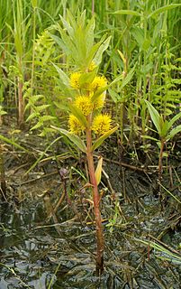
Lysimachia thyrsiflora, the tufted loosestrife, is a plant in the genus Lysimachia. It is native to large sections of the northern Northern Hemisphere, including Eurasia and North America. It often grows in marshes, shorelines of lakes and ponds and occasionally along streams. It is an erect perennial herb growing up to 80 centimeters tall and bearing yellow flowers, sometimes dotted with purple. It may be confused with purple loosestrife when not blooming but can be easily distinguished because purple loosestrife has a square stem. Tufted loosestrife has been used medicinally in Asia to combat high blood pressure.

Purple moor grass and rush pastures is a type of Biodiversity Action Plan habitat in the UK. It occurs on poorly drained neutral and acidic soils of the lowlands and upland fringe. It is found in the South West of England, especially in Devon.

Chyenhal Moor is a poorly drained shallow valley, 2 miles (3.2 km) to the south-west of Penzance, Cornwall. Due to several rare plants in a diverse range of habitats, it was notified as a Site of Special Scientific Interest (SSSI) in 1951.

Bewick and Beanley Moors is the name given to a Site of Special Scientific Interest (SSSI) in north Northumberland, in the north-east of England. The moors are asserted to be of national importance by Natural England for the extent, quality and diversity of upland types including heaths, fens, wet grassland, flushes, mires and blanket bogs, together creating an extensive mosaic habitat supporting an exceptional community of amphibians. The moors are important, too, for their relict juniper woodland and scrub.

Salta Moss is a raised blanket mire which is a Site of Special Scientific Interest ('SSSI') located in the hamlet of Salta, in Cumbria, United Kingdom. It was determined to be of biological interest under the Wildlife and Countryside Act 1981. The site, measuring 45.6 hectares, was officially designated in August 1982.
References
- Rodwell, J. S. (1991) British Plant Communities Volume 1 - Woodlands and scrub ISBN 0-521-23558-8 (hardback), ISBN 0-521-62721-4 (paperback)