Related Research Articles

Aire Point to Carrick Du SSSI is a Site of Special Scientific Interest on the Penwith Peninsula, Cornwall, England. It is 5.98 square kilometres in extent, stretching from grid reference SW360279 to grid reference SW513410. The site is designated both for its biological and its geological interest.
This article gives an overview of the heath communities in the British National Vegetation Classification system.
NVC community H3 is one of the heath communities in the British National Vegetation Classification system. It is one of three communities which are considered transitional between the lowland dry heaths and the wetter communities classified in the NVC as mires.
NVC community H1 is one of the heath communities in the British National Vegetation Classification system. It is one of five communities categorised as lowland dry heaths.
NVC community H2 is one of the heath communities in the British National Vegetation Classification system. It is one of five communities categorised as lowland dry heaths.
NVC community H4 is one of the heath communities in the British National Vegetation Classification system. It is one of three communities which are considered transitional between the lowland dry heaths and the wetter communities classified in the NVC as mires.
NVC community H5 is one of the heath communities in the British National Vegetation Classification system. It is one of three communities which are considered transitional between the lowland dry heaths and the wetter communities classified in the NVC as mires.
NVC community CG2 is one of the calcicolous grassland communities in the British National Vegetation Classification system. It is one of three short-sward communities associated with heavy grazing, within the lowland calcicolous grassland group, and is regarded as "typical" chalk grassland.
NVC community H6 is one of the heath communities in the British National Vegetation Classification system. It is one of five communities categorised as lowland dry heaths.
British NVC community MC10 is one of the maritime cliff communities in the British National Vegetation Classification system. It is one of five communities categorised as maritime sea-cliff grasslands.
NVC community CG10 is one of the calcicolous grassland communities in the British National Vegetation Classification system. Of the upland group of calcicolous grasslands, it is the only one with a short sward associated with heavy grazing.
British NVC community MG5 is one of the mesotrophic grassland communities in the British National Vegetation Classification system. It is one of four such communities associated with well-drained permanent pastures and meadows.
British NVC community MG3 is one of the mesotrophic grassland communities in the British National Vegetation Classification system. It is one of four such communities associated with well-drained permanent pastures and meadows.
British NVC community MC5 is one of the maritime cliff communities in the British National Vegetation Classification system. It is one of five communities categorised as maritime cliff crevice and ledge communities.
British NVC community MC12 is one of the maritime cliff communities in the British National Vegetation Classification system. It is one of five communities categorised as maritime sea-cliff grasslands.
NVC community CG1 is one of the calcicolous grassland communities in the British National Vegetation Classification system. It is one of three short-sward communities associated with heavy grazing, within the lowland calcicolous grassland group, and is regarded as the south-west coastal counterpart of "typical" chalk grassland.

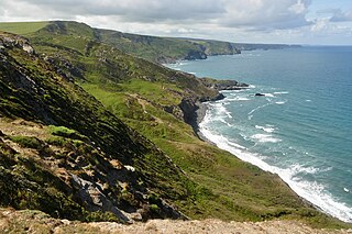
Treen Cliff is a Site of Special Scientific Interest (SSSI) located on the Penwith Peninsula in Cornwall, England, UK, 6 miles (9.7 km) south-west of Penzance. First notified in 1951, with a revision in 1973, and a further notification on 1 July 1986, it is 49.3 hectares in area, stretching from grid reference SW387220 to SW402225. Designated for both for its biological and geological interest, part of the site, Treryn Dinas, is a Scheduled Ancient Monument consisting of a "cliff castle" with four ramparts and ditches and the Logan Rock. It is within the Cornwall Area of Outstanding Natural Beauty (AONB), the Penwith Heritage Coast and is part owned and managed by the National Trust.
Boscastle to Widemouth is a coastal Site of Special Scientific Interest (SSSI) in Cornwall, England, noted for its biological and geological characteristics. The Dizzard dwarf oak woodland is unique and of international importance for its lichen communities, with 131 species recorded.

Peninnis Head is the southernmost point of St Mary's, Isles of Scilly. The headland is within the Isles of Scilly Area of Outstanding Natural Beauty and part of the Heritage Coast. It is also a Geological Conservation Review site for its Quaternary geomorphology and was first designated a Site of Special Scientific Interest (SSSI) in 1971 for both its biological and geological interests. On the tip of the headland is a squat lighthouse built in 1911 by Trinity House as a replacement for the 17th century lighthouse on St Agnes.

Bamburgh Coast and Hills is the name given to a Site of Special Scientific Interest (SSSI) on the coast of north Northumberland, England. The site is one of the longest-standing SSSIs in England, having been listed since 1954, and displays the interaction of a fluid magma rock, now known as the Whin Sill, interacting with older sedimentary rock. Coastal erosion at the site enables sections of the geological strata to be seen. In turn, the soil associated with the Whin Sill gives rise to a distinct pattern of vegetation which on its own merits is at this site found notable.
References
- Rodwell, J. S. (1991) British Plant Communities Volume 2 - Mires and heaths ISBN 0-521-39165-2 (hardback), ISBN 0-521-62720-6 (paperback)