Related Research Articles

Holkham National Nature Reserve is England's largest national nature reserve (NNR). It is on the Norfolk coast between Burnham Overy Staithe and Blakeney, and is managed by Natural England with the cooperation of the Holkham Estate. Its 3,900 hectares comprise a wide range of habitats, including grazing marsh, woodland, salt marsh, sand dunes and foreshore. The reserve is part of the North Norfolk Coast Site of Special Scientific Interest, and the larger area is additionally protected through Natura 2000, Special Protection Area (SPA) and Ramsar listings, and is part of both an Area of Outstanding Natural Beauty (AONB) and a World Biosphere Reserve. Holkham NNR is important for its wintering wildfowl, especially pink-footed geese, Eurasian wigeon and brant geese, but it also has breeding waders, and attracts many migrating birds in autumn. A number of scarce invertebrates and plants can be found in the dunes, and the reserve is one of the only two sites in the UK to have an antlion colony.

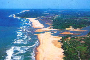
A salt marsh or saltmarsh, also known as a coastal salt marsh or a tidal marsh, is a coastal ecosystem in the upper coastal intertidal zone between land and open saltwater or brackish water that is regularly flooded by the tides. It is dominated by dense stands of salt-tolerant plants such as herbs, grasses, or low shrubs. These plants are terrestrial in origin and are essential to the stability of the salt marsh in trapping and binding sediments. Salt marshes play a large role in the aquatic food web and the delivery of nutrients to coastal waters. They also support terrestrial animals and provide coastal protection.

Crambe maritima, common name sea kale, seakale or crambe, is a species of halophytic (salt-tolerant) flowering plant in the genus Crambe of the family Brassicaceae. It grows wild along the coasts of mainland Europe and the British Isles.
An aquatic ecosystem is an ecosystem in and surrounding a body of water. They are contrasted with terrestrial ecosystems which are those found on land. Communities of organisms that are dependent on each other and on their environment live in aquatic ecosystems. The two main types of aquatic ecosystems are marine ecosystems and freshwater ecosystems. Freshwater ecosystems may be Lentic ; lotic ; and wetlands.

The Eastern Desert is the part of the Sahara desert that is located east of the Nile river. It spans 223,000 square kilometres (86,000 sq mi) of North-Eastern Africa and is bordered by the Nile river to the west and the Red Sea and Gulf of Suez to the east. It extends through Egypt, Eritrea, Sudan and Ethiopia. The Eastern Desert is also known as the Red Sea Hills. The Desert consists of a mountain range which runs parallel to the coast, wide sedimentary plateaus extending from either side of the mountains and the Red Sea coast. The rainfall, climate, vegetation and animal life sustained in the desert varies between these different regions.The Desert has been a mining site for building materials, and precious and semi-precious metals throughout history. It has historically contained many trade routes leading to and from the Red Sea, including the Suez Canal.
British NVC community SM10 is one of the salt-marsh communities in the British National Vegetation Classification system.
This article gives an overview of the salt-marsh communities in the British National Vegetation Classification system.
British NVC community MC7 is one of the maritime cliff communities in the British National Vegetation Classification system. It is one of two communities associated with sea-bird cliffs.
NVC community W3 is one of the woodland communities in the British National Vegetation Classification system.
British NVC community SM1 is one of the salt-marsh communities in the British National Vegetation Classification system.
British NVC community MG11 is one of the mesotrophic grassland communities in the British National Vegetation Classification system. It is one of three types of mesotrophic grassland classified as grass-dominated inundation communities.
British NVC community MC6 is one of the maritime cliff communities in the British National Vegetation Classification system. It is one of two communities associated with sea-bird cliffs.
British NVC community MC10 is one of the maritime cliff communities in the British National Vegetation Classification system. It is one of five communities categorised as maritime sea-cliff grasslands.
British NVC community MC12 is one of the maritime cliff communities in the British National Vegetation Classification system. It is one of five communities categorised as maritime sea-cliff grasslands.
Salt pannes and pools are water retaining depressions located within salt and brackish marshes. Pools tend to retain water during the summer months between high tides, whereas pannes generally do not. Salt pannes generally start when a mat of organic debris is deposited upon existing vegetation, killing it. This creates a slight depression in the surrounding vegetation which retains water for varying periods of time. Upon successive cycles of inundation and evaporation the panne develops an increased salinity greater than that of the larger body of water. This increased salinity dictates the type of flora and fauna able to grow within the panne. Salt pools are also secondary formations, though the exact mechanism(s) of formation are not well understood; some have predicted they will increase in size and abundance in the future due to rising sea levels.
British NVC community OV9 is one of the open habitat communities in the British National Vegetation Classification system. It is one of eight arable weed and wasteland communities of fertile loams and clays.
British NVC community OV8 is one of the open habitat communities in the British National Vegetation Classification system. It is one of eight arable weed and wasteland communities of fertile loams and clays.
British NVC community OV16 is one of the open habitat communities in the British National Vegetation Classification system. It is one of two arable weed communities of light lime-rich soils.
British NVC community OV17 is one of the open habitat communities in the British National Vegetation Classification system. Although classed with communities OV15 and OV16 as an arable weed community of light lime-rich soils, it also shares many features with the communities classed as arable weed and wasteland communities of fertile loams and clays.
British NVC community OV19 is one of the open habitat communities in the British National Vegetation Classification system. It is one of six communities characteristic of gateways, tracksides and courtyards.
References
- Rodwell, J. S. (2000) British Plant Communities Volume 5 - Maritime communities and vegetation of open habitats ISBN 0-521-39167-9 (hardback), ISBN 0-521-64476-3 (paperback)