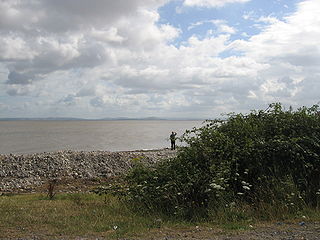
Bridgwater Bay is on the Bristol Channel, 5 kilometres (3.1 mi) north of Bridgwater in Somerset, England at the mouth of the River Parrett and the end of the River Parrett Trail. It stretches from Minehead at the southwestern end of the bay to Brean Down in the north. The area consists of large areas of mudflats, saltmarsh, sandflats and shingle ridges, some of which are vegetated. It has been designated as a Site of Special Scientific Interest (SSSI) covering an area of 3,574.1 hectares since 1989, and is designated as a wetland of international importance under the Ramsar Convention. The risks to wildlife are highlighted in the local Oil Spill Contingency Plan.

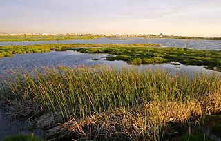
A salt marsh or saltmarsh, also known as a coastal salt marsh or a tidal marsh, is a coastal ecosystem in the upper coastal intertidal zone between land and open saltwater or brackish water that is regularly flooded by the tides. It is dominated by dense stands of salt-tolerant plants such as herbs, grasses, or low shrubs. These plants are terrestrial in origin and are essential to the stability of the salt marsh in trapping and binding sediments. Salt marshes play a large role in the aquatic food web and the delivery of nutrients to coastal waters. They also support terrestrial animals and provide coastal protection.

Zuiderduintjes is an uninhabited island in the Wadden Sea in the Netherlands. It is situated south of Rottumeroog, east of Rottumerplaat, and west of Borkum. The island is one of the three West Frisian Islands in the municipality of Het Hogeland and in the province of Groningen.
British NVC community SM10 is one of the salt-marsh communities in the British National Vegetation Classification system.
This article gives an overview of the swamp and tall-herb fen communities in the British National Vegetation Classification system.
This article gives an overview of the plant communities formed by vegetation of open habitats in the British National Vegetation Classification system.
California's coastal salt marsh is a wetland plant community that occurs sporadically along the Pacific Coast from Humboldt Bay to San Diego. This salt marsh type is found in bays, harbors, inlets, and other protected areas subject to tidal flooding.

Portencross is a hamlet near Farland Head in North Ayrshire, Scotland. Situated about three kilometres west of Seamill and about two kilometres south of Hunterston B nuclear power station, it is noted for Portencross Castle.
British NVC community SM24 is one of the salt-marsh communities in the British National Vegetation Classification system.

The Giardino Botanico Litoraneo di Porto Caleri, also known as the Giardino Botanico Litoraneo del Veneto, is a nature preserve and botanical garden located on Via Porto Caleri, Rosolina Mare, Rosolina, Province of Rovigo, Veneto, Italy. It is open several days a week in the warmer months.
Salt pannes and pools are water retaining depressions located within salt and brackish marshes. Pools tend to retain water during the summer months between high tides, whereas pannes generally do not. Salt pannes generally start when a mat of organic debris is deposited upon existing vegetation, killing it. This creates a slight depression in the surrounding vegetation which retains water for varying periods of time. Upon successive cycles of inundation and evaporation the panne develops an increased salinity greater than that of the larger body of water. This increased salinity dictates the type of flora and fauna able to grow within the panne. Salt pools are also secondary formations, though the exact mechanism(s) of formation are not well understood; some have predicted they will increase in size and abundance in the future due to rising sea levels.
The Rietvlei Wetland Reserve is a 663-hectare (1,640-acre) nature reserve situated in Table View, Western Cape, South Africa. It is managed by the City of Cape Town's Environmental Resource Management Department.

Aber Taf is a large Site of Special Scientific Interest (SSSI) in Carmarthenshire, Wales, and forms part of the Carmarthen Bay and Estuaries Special Area of Conservation.

Alnmouth Saltmarsh and Dunes is a Site of Special Scientific Interest (SSSI) in Northumberland, England. It is the largest saltflat on the north-east coast, located on the south bank of the River Aln estuary, and notable for the varied plant community found on the interface between the saltflats and the dunes. It overlaps with and forms part of the much larger Northumberland Shore SSSI.

The Waddensea of Hamburg between Elbe and Weser is a German Biosphere reserve. It was added in 1992 by the UNESCO in their "man and biosphere" (MAB).

Milford Haven Waterway, is a Site of Special Scientific Interest (SSSI) on Milford Haven Waterway in Pembrokeshire, South Wales, designated since 2002. The site is protected for a wide range of reasons, including its geology, marine environment and ecosystems, and to protect a diversity of flora and fauna.
The marsh organ is a collection of plastic pipes attached to a wooden framework that is placed in marshes to measure water level changes for research purposes.
This page is based on this
Wikipedia article Text is available under the
CC BY-SA 4.0 license; additional terms may apply.
Images, videos and audio are available under their respective licenses.