Poltesco

Last updated

Poltesco
Poltesco Serpentine Works 1 - geograph.org.uk - 1263630.jpg
Poltesco serpentine works, Cornwall
Cornwall UK location map.svg
Red pog.svg
Poltesco
two miles north-east of Lizard Point on the eastern side of the Lizard peninsula
Geography
CountryEngland
State Cornwall
Region South West England
District The Lizard
Coordinates 49°59′51″N5°10′40″W / 49.9976174°N 5.177778°W / 49.9976174; -5.177778 Coordinates: 49°59′51″N5°10′40″W / 49.9976174°N 5.177778°W / 49.9976174; -5.177778
Map Ref: SW7216

Poltesco is a hamlet and valley in the parish of Grade-Ruan, on the Lizard Peninsula, Cornwall, UK. The lower part of the valley is owned by the National Trust and was once the site of a stone industry that exported carved ornaments to the rest of Britain and Europe.

Contents

Geography

The Poltesco stream drains the southern part of Goonhilly Downs and reaches the sea at Carleon Cove on the east coast of the Lizard. At the head of a small tributary, on the downs, are the remains of South Wheal Treasure copper mine, working in 1823. The walls of three or four large buildings, including an engine house, can still be seen. A lode has not been located. [1]

The streams flows through a wooded valley and discharges at Carleon Cove on the east side of the Lizard Peninsula. Less than 1 km to the north-east is the beach at Kennack Sands and 1 km to the south-west the village of Cadgwith. The South West Coast Path, which follows the coast of south-west England from Somerset to Dorset, crosses the Poltesco stream at Carleon Cove. [2] The valley forms part of the Cornwall Area of Outstanding Natural Beauty and is within the Caerthillian to Kennack Site of Special Scientific Interest (SSSI). The tree and shrub cover makes Poltesco an unusual feature of the windswept peninsula.

History

From the early 14th century to the late part of the 19th century, there was an important fishery operating out of Carleon Cove which included a pilchard fishery documented from the early part of the 18th century to the early part of the 19th century. Many of the buildings were reused by the late 19th-century serpentine factory. [3] The only visible evidence of the fishing industry is the round, roofless building in the cove, housing the capstan which was used to haul boats out of the water. [4]

A water mill and mill pool (grid reference SW723157 ) still survive on the southern side of the valley, built mostly in the 18th and 19th centuries and possibly dating back to the 14th century. There is a crucifixion figure carved inside the building which may be medieval. The waterwheel dates from the 1870s. [5]

Lizard Serpentine Company

The first written evidence of worked serpentine is from 1828, when a Mr Drew of Penzance, who was repairing the Lizard Lighthouse, carved serpentine in his spare time. It is likely that he learnt it from a long-established local tradition. Serpentine had been used locally for dwellings, farm buildings, stiles, etc., and to build several church towers such as at Mullion and Landewednack. A tour of the Penzance serpentine works, in 1846, by Prince Albert and the royal family, resulted in an order for mantelpieces and pedestals for Osborne House on the Isle of Wight. Interest in serpentine products continued to increase following The Great Exhibition of 1851, which was visited by six million people and showcased products from all of the world. [6] The Lizard Serpentine Company built a factory at Poltesco in 1855 and later increased the buildings to include a showroom, warehouse and offices. The walls were of snecked serpentine blocks, and the roof had clay ridge tiles and a scantle slate roof. The company had a showroom on the Strand, London, where there was a 7-foot-6-inch-tall (2.29 m) vase on display. Stone came from local quarries by cart, and the finished stoneware was ferried in flat-bottomed barges to schooners offshore. [7] The company was wound up in 1870 and relaunched as the Poltesco Marble Company. [6]

Demise of the serpentine industry

Notably, the Poltesco Marble Company omitted the word ′serpentine′ from its name. A water wheel, built by Mr Toy of Helston, was completed in 1881 and according to The Cornishman newspaper the large showroom was ″well worth a visit and was filled with carvings of all sorts, shapes, sizes and values″. [8] By 1883 the factory had reduced its workforce to twenty men and three boys, and the products were smaller and less grand, although another report in The Cornishman newspaper stated that the showrooms were well worth a visit. [9]

There was a number of factors for the demise of the industry. The serpentine rock used for carving came from small seams within a larger mineral complex, and the search for unflawed large pieces of rock exhausted the small quarries, which raised costs. Fashions change, serpentine was no longer a novelty and its poor weathering qualities made it unsuitable for outside use. In 1893 the company was wound up due to falling demand, and the uninsured loss at sea of finished products. Machinery of value was sold off, and the buildings were abandoned, to leave walkers on the coastal footpath to view a post-industrial landscape. During the First World War, some of the buildings were requisitioned as a carpenter's workshop and children's playroom. [6] The water wheel remained in use for chaffing until 1917, when it was removed. [3] Between the wars the site was considered for a holiday camp, and some of the works were partially demolished in 1923 with explosives. [3] Carleon House was leased to the manager Herbert Cohen in 1889, and his daughter bought it and lived there until 1947. The house and valley now belong to the National Trust. [6]

Remains can still be seen on the shore of Carleon Cove along with the roofless capstan from the fishing industry.

Related Research Articles

Lamorna Human settlement in England

Lamorna is a village, valley and cove in west Cornwall, England, UK. It is on the Penwith peninsula approximately 4 miles (6 km) south of Penzance. Lamorna became popular with the artists of the Newlyn School, including Alfred Munnings, Laura Knight and Harold Knight, and is also known for former residents Derek and Jean Tangye who farmed land and wrote "The Minack Chronicles".

Penwith Area in west Cornwall, England

Penwith is an area of Cornwall, England, United Kingdom, located on the peninsula of the same name. It is also the name of a former local government district, whose council was based in Penzance. The area is named after one of the ancient administrative hundreds of Cornwall which derives from two Cornish words, penn meaning 'headland' and wydh meaning 'at the end'.

Kenidjack Valley Valley in Cornwall, United Kingdom

Kenidjack Valley, sometimes referred to as Nancherrow Valley, is a steep-sided valley in Cornwall, United Kingdom.

Porthleven Port in England

Porthleven is a town, civil parish and fishing port near Helston in Cornwall, England, UK. As the most southerly port in Great Britain, it was originally developed as a harbour of refuge, when this part of the Cornish coastline was infamous for wrecks in the days of sail. The South West Coast Path from Somerset to Dorset passes through the town. An electoral ward called Porthleven and Helston South also exists. The population at the 2011 census was 3,059. It was estimated to be 3,141 in 2019.

Lizard Point, Cornwall Human settlement in England

Lizard Point in Cornwall is at the southern tip of the Lizard Peninsula. It is situated half-a-mile (800 m) south of Lizard village in the civil parish of Landewednack and about 11 miles (18 km) southeast of Helston.

Chacewater Human settlement in England

Chacewater is a village and civil parish in Cornwall, England, UK. It is situated approximately 3 miles (4.8 km) east of Redruth. The hamlets of Carnhot, Cox Hill, Creegbrawse, Hale Mills, Jolly's Bottom, Salem, Saveock, Scorrier, Todpool, Twelveheads and Wheal Busy are in the parish. The electoral ward is called Chacewater & Kenwyn. At the 2011 census a population of 3,870 was quoted.
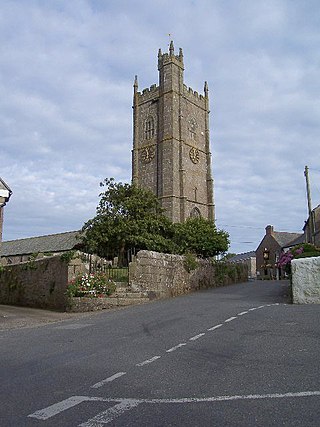
Cadgwith Human settlement in England

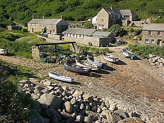
Cadgwith is a village and fishing port in Cornwall, England, United Kingdom. It is on the Lizard Peninsula between The Lizard and Coverack. It is in the civil parish of Grade Ruan.

Prussia Cove Human settlement in England

Prussia Cove, formerly called King's Cove, is a small private estate on the coast of Mount's Bay and to the east of Cudden Point, west Cornwall, England, United Kingdom. Part of the area is designated as a Site of Special Scientific Interest (SSSI), a Geological Conservation Review site and is in an Area of Outstanding Natural Beauty (AONB). It consists of four small coves and several cottages and houses. The names of the coves from west to east are Piskies, Bessy's, King's and Coule's. The area is accessible by foot from the South West Coast Path The cove is known for the 18th-century ship-wrecker and smuggler John Carter, also known as the "King of Prussia".

Mullion, Cornwall Human settlement in England

Mullion is a civil parish and village on the Lizard Peninsula in south Cornwall, England, United Kingdom. The nearest town is Helston approximately 5 miles (8 km) to the north.
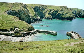
Mullion Cove

Mullion Cove or Porth Mellin is a small community on the west coast of the Lizard Peninsula in Cornwall, England. It is on the eastern side of the Mount's Bay. The Cove forms part of the parish of Mullion, and is accessible by road from Mullion village, 1 mile (1.6 km) away to the north east, and also by the popular South West coast path. It lies within an Area of Outstanding Natural Beauty

Penberth

Penberth is a valley, coastal village and cove on the Penwith peninsula in Cornwall, England. It is approximately 7 miles (11 km) southwest of Penzance. Most of the village is within the parish of St Buryan and the boundary with St Levan follows the Penberth river.

Wherrytown

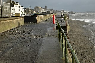
Wherrytown is a small settlement in west Cornwall, United Kingdom, on the east side of the Laregan River, between Newlyn and Penzance. It was formerly in the civil parish of Madron and was incorporated into the Borough of Penzance in 1934 when local government was reorganised.

Gwennap Human settlement in England

Gwennap is a village and civil parish in Cornwall, England. It is about five miles (8 km) southeast of Redruth. Hamlets of Burncoose, Comford, Coombe, Crofthandy, Cusgarne, Fernsplatt, Frogpool, Goon Gumpas Hick's Mill, Tresamble and United Downs lie in the parish, as does Little Beside country house.

Gurnards Head

Gurnard's Head is a prominent headland on the north coast of the Penwith peninsula in Cornwall, England, UK. The name is supposed to reflect that the rocky peninsula resembles the head of the gurnard fish.

Tuckingmill, Camborne, Cornwall Human settlement in England

Tuckingmill is a village in Cornwall, England, United Kingdom, which is in the civil parish of Camborne. Tucking Mill was the Cornish term for a fulling mill which was where homespun cloth was dipped, cleansed and dressed. There is a mention of a fulling mill in this region as early as 1250. The ecclesiastical parish of Tuckingmill was constituted in 1845, being carved out of a western section of the parish of Illogan and an eastern section of Camborne parish. It covers 1,300 acres (5.3 km2).

Fishing in Cornwall Economic activity

Fishing in Cornwall, England, UK, has traditionally been one of the main elements of the economy of the county. Pilchard fishing and processing was a thriving industry in Cornwall from around 1750 to around 1880, after which it went into an almost terminal decline. During the 20th century the varieties of fish taken became much more diverse and crustaceans such as crab and lobster are now significant. Much of the catch is exported to France due to the higher prices obtainable there. Though fishing has been significantly damaged by overfishing, the Southwest Handline Fishermen's Association has started to revive the fishing industry. As of 2007, stocks are improving. The Cornwall Sea Fisheries Committee is one of 12 such committees responsible for managing the corresponding Sea Fisheries District. The Isles of Scilly Sea Fisheries Committee is responsible for the Scilly district.

Sancreed Beacon

Sancreed Beacon is a Bronze Age archaeological site near the village of Sancreed in the Penwith peninsula of Cornwall maintained by the Cornwall Heritage Trust. On top of the hill are several stone cists and Bronze Age archaeological remains comprising burial mounds and the remains of a Bronze Age hut on the Western slope.

Porthallow Human settlement in England

Porthallow is a small fishing village on the east coast of The Lizard peninsula to the south of the Helford River, in Cornwall, England, United Kingdom. It sits between the two neighbouring villages of St Keverne and Roskorwell. One road runs through the village, and there is public house, the Five Pilchards, named for the pilchard fishery. Porthallow lies at the midpoint of the South West Coast Path and is within the Cornwall Area of Outstanding Natural Beauty (AONB).

Asparagus Island Small tidal island on the eastern side of Mounts Bay, within the parish of Mullion, Cornwall

Asparagus Island is a small tidal island on the eastern side of Mount's Bay, within the parish of Mullion, Cornwall, United Kingdom. It lies within Kynance Cove, a popular tourist site on the western side of The Lizard peninsula and is named after the rare wild asparagus (Asparagus prostratus) found there.

Madron Well and Madron Well Chapel Ruined medieval chapel in England

Madron Well and Madron Well Chapel is a scheduled Ancient Monument in the civil parish of Madron, Cornwall, UK.

References

  1. "South Wheal Treasure". Pastscape. Historic England. Retrieved 20 December 2015.
  2. The Lizard (A2 ed.). Southampton: Ordnance Survey. 2010. ISBN   978-0-319-24117-2.
  3. 1 2 3 "Carleon Cove Serpentine Factory". Pastscape. Historic England. Retrieved 20 December 2015.
  4. "Mills, fishing and serpentine walk". National Trust. Retrieved 16 December 2015.
  5. "Poltesco Mill". Pastscape. Historic England. Retrieved 20 December 2015.
  6. 1 2 3 4 Sagar-Fenton, Michael; Smith, Stuart B (2005). Serpentine. Mount Hawke: Truran. ISBN   1-85022-199-5.
  7. Bates, Robin; Scolding, Bill (2000). Beneath the Skin of The Lizard. Truro: Cornwall County Council. pp. 19–23. ISBN   1-898166-09-9.
  8. "A Visit To The Serpentine Districts Of Cornwall". The Cornishman. No. 143. 7 April 1881. p. 5.
  9. "The Industries Of Penzance And Its Neighbourhood. No IX. The Manufacture Of Serpentine". The Cornishman. No. 256. 7 June 1883. p. 7.