
Sclerophyll is a type of vegetation that is adapted to long periods of dryness and heat. The plants feature hard leaves, short internodes and leaf orientation which is parallel or oblique to direct sunlight. The word comes from the Greek sklēros (hard) and phyllon (leaf). The term was coined by A.F.W. Schimper in 1898, originally as a synonym of xeromorph, but the two words were later differentiated.

A savanna or savannah is a mixed woodland-grassland biome and ecosystem characterised by the trees being sufficiently widely spaced so that the canopy does not close. The open canopy allows sufficient light to reach the ground to support an unbroken herbaceous layer consisting primarily of grasses. Four savanna forms exist; savanna woodland where trees and shrubs form a light canopy, tree savanna with scattered trees and shrubs, shrub savanna with distributed shrubs, and grass savanna where trees and shrubs are mostly nonexistent.

Tropical and subtropical moist broadleaf forests (TSMF), also known as tropical moist forest, is a subtropical and tropical forest habitat type defined by the World Wide Fund for Nature.

The Thousand Islands – Frontenac Arch region or the Frontenac Axis is an exposed strip of Precambrian rock in Canada and the United States that links the Canadian Shield from Algonquin Park with the Adirondack Mountain region in New York, an extension of the Laurentian mountains of Québec. The Algonquin to Adirondacks region, which includes the Frontenac Axis or Arch, is a critical linkage for biodiversity and resilience, and one with important conservation potential. The axis separates the St. Lawrence Lowlands and the Great Lakes Lowlands. It has many distinctive plant and animal species. It is one of four ecoregions of the Mixedwood Plains.

Temperate rainforests are rainforests with coniferous or broadleaf forests that occur in the temperate zone and receive heavy rain.
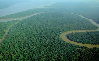
Tropical rainforests are dense and warm rainforests with high rainfall typically found between 10° north and south of the Equator. They are a subset of the tropical forest biome that occurs roughly within the 28° latitudes. Tropical rainforests are a type of tropical moist broadleaf forest, that includes the more extensive seasonal tropical forests. True rainforests usually occur in tropical rainforest climates where no dry season occurs; all months have an average precipitation of at least 60 mm (2.4 in). Seasonal tropical forests with tropical monsoon or savanna climates are sometimes included in the broader definition.

Flatwoods, pineywoods, pine savannas and longleaf pine–wiregrass ecosystem are terms that refer to an ecological community in the southeastern coastal plain of North America. Flatwoods are an ecosystem maintained by wildfire or prescribed fire and are dominated by longleaf pine, and slash pine in the tree canopy and saw palmetto, gallberry and other flammable evergreen shrubs in the understory, along with a high diversity of herb species. It was once one of the dominant ecosystem types of southeastern North America. Although grasses and pines are characteristic of this system, the precise composition changes from west to east, that is, from Texas to Florida. In Louisiana, savannas even differ between the east and west side of the Mississippi River. The key factor maintaining this habitat type is recurring fire. Without fire, the habitat is eventually invaded by other species of woody plants.
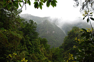
Laurel forest, also called laurisilva or laurissilva, is a type of subtropical forest found in areas with high humidity and relatively stable, mild temperatures. The forest is characterized by broadleaf tree species with evergreen, glossy and elongated leaves, known as "laurophyll" or "lauroid". Plants from the laurel family (Lauraceae) may or may not be present, depending on the location.

Fire ecology is a scientific discipline concerned with the effects of fire on natural ecosystems. Many ecosystems, particularly prairie, savanna, chaparral and coniferous forests, have evolved with fire as an essential contributor to habitat vitality and renewal. Many plant species in fire-affected environments use fire to germinate, establish, or to reproduce. Wildfire suppression not only endangers these species, but also the animals that depend upon them.

Shrubland, scrubland, scrub, brush, or bush is a plant community characterized by vegetation dominated by shrubs, often also including grasses, herbs, and geophytes. Shrubland may either occur naturally or be the result of human activity. It may be the mature vegetation type in a particular region and remain stable over time, or a transitional community that occurs temporarily as the result of a disturbance, such as fire. A stable state may be maintained by regular natural disturbance such as fire or browsing. Shrubland may be unsuitable for human habitation because of the danger of fire. The term was coined in 1903.

The Coastal forests of eastern Africa, also known as the East African Coastal Forests or Zanzibar–Inhambane forests, is a tropical moist forest region along the east coast of Africa. The region was designated a biodiversity hotspot by Conservation International.
Altitudinal zonation in mountainous regions describes the natural layering of ecosystems that occurs at distinct elevations due to varying environmental conditions. Temperature, humidity, soil composition, and solar radiation are important factors in determining altitudinal zones, which consequently support different vegetation and animal species. Altitudinal zonation was first hypothesized by geographer Alexander von Humboldt who noticed that temperature drops with increasing elevation. Zonation also occurs in intertidal and marine environments, as well as on shorelines and in wetlands. Scientist C. Hart Merriam observed that changes in vegetation and animals in altitudinal zones map onto changes expected with increased latitude in his concept of life zones. Today, altitudinal zonation represents a core concept in mountain research.

The Coast Range ecoregion is a Level III ecoregion designated by the Environmental Protection Agency (EPA) in the U.S. states of Washington, Oregon, and California. It stretches along the Pacific Coast from the tip of the Olympic Peninsula in the north to the San Francisco Bay in the south, including Grays Harbor, Willapa Bay, and the Long Beach Peninsula in Washington, the entire length of the Oregon Coast, and the Northern California Coast. Named for the Coast Range mountains, it encompasses the lower elevations of the Olympic Mountains, the Oregon Coast Range, the Californian North Coast Ranges, and surrounding lowlands.
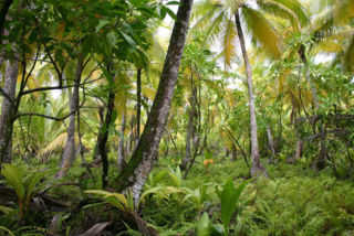
Plant ecology is a subdiscipline of ecology that studies the distribution and abundance of plants, the effects of environmental factors upon the abundance of plants, and the interactions among plants and between plants and other organisms. Examples of these are the distribution of temperate deciduous forests in North America, the effects of drought or flooding upon plant survival, and competition among desert plants for water, or effects of herds of grazing animals upon the composition of grasslands.

Mediterranean forests, woodlands and scrub is a biome defined by the World Wide Fund for Nature. The biome is generally characterized by dry summers and rainy winters, although in some areas rainfall may be uniform. Summers are typically hot in low-lying inland locations but can be cool near colder seas. Winters are typically mild to cool in low-lying locations but can be cold in inland and higher locations. All these ecoregions are highly distinctive, collectively harboring 10% of the Earth's plant species.

Montane ecosystems are found on the slopes of mountains. The alpine climate in these regions strongly affects the ecosystem because temperatures fall as elevation increases, causing the ecosystem to stratify. This stratification is a crucial factor in shaping plant community, biodiversity, metabolic processes and ecosystem dynamics for montane ecosystems. Dense montane forests are common at moderate elevations, due to moderate temperatures and high rainfall. At higher elevations, the climate is harsher, with lower temperatures and higher winds, preventing the growth of trees and causing the plant community to transition to montane grasslands and shrublands or alpine tundra. Due to the unique climate conditions of montane ecosystems, they contain increased numbers of endemic species. Montane ecosystems also exhibit variation in ecosystem services, which include carbon storage and water supply.
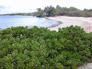
Tropical vegetation is any vegetation in tropical latitudes. Plant life that occurs in climates that are warm year-round is in general more biologically diverse than in other latitudes. Some tropical areas may receive abundant rain the whole year round, but others have long dry seasons which last several months and may vary in length and intensity with geographic location. These seasonal droughts have a great impact on the vegetation, such as in the Madagascar spiny forests.
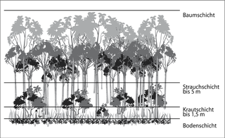
In ecology, stratification refers to the vertical layering of a habitat; the arrangement of vegetation in layers. It classifies the layers of vegetation largely according to the different heights to which their plants grow. The individual layers are inhabited by different animal and plant communities (stratozones).

The Cumberland Plain Woodland, also known as Cumberland Plain Bushland and Western Sydney woodland, is a grassy woodland community found predominantly in Western Sydney, New South Wales, Australia, that comprises an open tree canopy, a groundcover with grasses and herbs, usually with layers of shrubs and/or small trees.
Sri Lanka exhibits a remarkable biological diversity and is considered to be the richest country in Asia in terms of species concentration.


