
St Brides Bay is a bay in western Pembrokeshire, West Wales.

Crackington Haven is a coastal village in Cornwall, England, United Kingdom. It is in the civil parish of St Gennys at grid reference SX140972 at the head of a cove on the Atlantic coast. The village is seven miles (11 km) south-southwest of Bude and four miles (7 km) north-northeast of Boscastle.

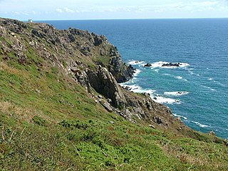
Aire Point to Carrick Du SSSI is a Site of Special Scientific Interest on the Penwith Peninsula, Cornwall, England. It is 5.98 square kilometres in extent, stretching from grid reference SW360279 to grid reference SW513410. The site is designated both for its biological and its geological interest.

Somerset is a rural county in the southwest of England, covering 4,171 square kilometres (1,610 sq mi). It is bounded on the north-west by the Bristol Channel, on the north by Bristol and Gloucestershire, on the north-east by Wiltshire, on the south-east by Dorset, and on the south west and west by Devon. It has broad central plains with several ranges of low hills. The landscape divides into four main geological sections from the Silurian through the Devonian and Carboniferous to the Permian which influence the landscape, together with water-related features.
The North Devon Coast was designated as an Area of Outstanding Natural Beauty in September 1959. The AONB contributes to a family of protected landscapes in the Southwest of England and a total of 38% of the region is classified by the International Union for Conservation of Nature as Category V Protected Landscapes. The twelve Areas of Outstanding Natural Beauty extend to 30% of the region, twice the proportion covered by AONBs in England as a whole and a further two National Parks, Dartmoor and Exmoor, cover an additional 7%.
Grass Wood is an ancient woodland of 88 hectares in Wharfedale, North Yorkshire, England, that has an exceptional ground flora of woodland wildflowers.
Westernhope Burn Wood is a Site of Special Scientific Interest in the Wear Valley district of south-west County Durham, England. It occupies the steeply-incised ravine of the Westernhope Burn, a tributary of the River Wear, which it joins from the south about halfway between the villages of Eastgate and Westgate.
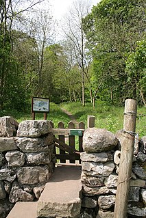
Cotterill Clough is a 5.6-hectare (14-acre) nature reserve near Manchester Airport. It is managed by the Cheshire Wildlife Trust and lies within a larger Site of Special Scientific Interest (SSSI). The Cotterill Brook, which flows through the reserve, is a tributary of the River Bollin. The reserve was purchased in 1934 by public subscription as a memorial to T. A. Coward (1867–1933), a famous Cheshire naturalist. It is 15 kilometres (9.3 mi) south of Manchester city centre and adjacent to Manchester Airport.

Treen Cliff is a Site of Special Scientific Interest (SSSI) located on the Penwith Peninsula in Cornwall, England, UK, 6 miles (9.7 km) south-west of Penzance. First notified in 1951, with a revision in 1973, and a further notification on 1 July 1986, it is 49.3 hectares in area, stretching from grid reference SW387220 to SW402225. Designated for both for its biological and geological interest, part of the site, Treryn Dinas, is a Scheduled Ancient Monument consisting of a "cliff castle" with four ramparts and ditches and the Logan Rock. It is within the Cornwall Area of Outstanding Natural Beauty (AONB), the Penwith Heritage Coast and is part owned and managed by the National Trust.

Dizzard is an area, in the civil parish of St Gennys, Cornwall, containing five farms. On the coast is Dizzard Point, and the unique, dwarf oak, Dizzard Wood, which is of international importance for its lichen communities.

Trevaunance Cove is a small bay on the north Cornish coast and a residential area of St Agnes, Cornwall, United Kingdom. In the 18th and 19th centuries it was a busy harbour despite storms often destroying the quay. The South West Coast Path passes over the coastal slope to the north.
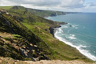
Boscastle to Widemouth is a coastal Site of Special Scientific Interest (SSSI) in Cornwall, England, noted for its biological and geological characteristics. The Dizzard dwarf oak woodland is unique and of international importance for its lichen communities, with 131 species recorded.

Caerthillian to Kennack is a coastal Site of Special Scientific Interest (SSSI) on the Lizard Peninsula in Cornwall, UK, noted for both its biological and geological characteristics. It is of great botanical importance, with several Red Data Book of rare and endangered plant species being found on the site, as well as a breeding site for Cornish choughs.

Steeple Point to Marsland Mouth is a coastal Site of Special Scientific Interest (SSSI) in Cornwall, England, UK, noted for its biological characteristics.

Kelsey Head is a coastal Site of Special Scientific Interest (SSSI) and headland in north Cornwall, England, UK, noted for its biological interest. The site contains an Iron Age hill fort.
Kennack to Coverack is a coastal Site of Special Scientific Interest (SSSI) on the Lizard Peninsula in Cornwall, England, UK, noted for both its biological and geological interest. It is of botanical importance, with 8 Red Data Book of rare and endangered plant species being found on the site as well as other nationally scarce varieties.
Nance Wood is a woodland Site of Special Scientific Interest (SSSI) near Portreath, west Cornwall. The site was first notified in 1951 for its almost pure dwarf, sessile oak coppiced woodland, good bryophyte flora and Irish spurge, which is found in only two localities in Britain.
Milford Haven Waterway, is a Site of Special Scientific Interest (SSSI) on Milford Haven Waterway in Pembrokeshire, South Wales, designated since 2002. The site is protected for a wide range of reasons, including its geology, marine environment and ecosystems, and to protect a diversity of flora and fauna.


