
North Cornwall is an area of Cornwall, England, United Kingdom. It is also the name of a former local government district, which was administered from Bodmin and Wadebridge 50.516°N 4.835°W. Other towns in the area are Launceston, Bude, Padstow, and Camelford.

Bude–Stratton is a coastal civil parish with a town council in Cornwall, England, United Kingdom. According to the 2001 census it had a population of 9,242. In 2011 this population had increased to 9,934.

Marhamchurch is a civil parish and village in north Cornwall, England, United Kingdom.

Whitstone is a village and civil parish in east Cornwall, United Kingdom. It is roughly halfway between the towns of Bude and Launceston. The population at the 2011 census was 590.
The Okehampton–Bude line was a railway line built to serve Holsworthy in Devon, and Bude on the Cornish coast near the Devon border in England. The line branched from the main line at Meldon Junction to the west of Okehampton on the northern edge of Dartmoor. The line opened in 1879 to Holsworthy and in 1898 to Bude. It is now closed.
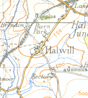
Halwill is a village in Devon, England just off the A3079 Okehampton to Holsworthy road. About a mile away on the main road is another settlement called Halwill Junction.

Halwill Junction Railway Station was a railway station in Halwill Junction, near the villages of Halwill and Beaworthy in Devon, England. It opened in 1879 and formed an important junction between the now-closed Bude Branch and North Cornwall line. It closed in 1966 along with the lines which it served, a casualty of the Beeching Report.
The Cornish Way is a cycle route which is part of the National Cycle Network that links Bude to Land's End. The route is via Padstow or St Austell and is 180 miles in length.

Forrabury and Minster is a civil parish on the north coast of Cornwall, England, United Kingdom. The parish was originally divided between the coastal parish of Forrabury and inland parish of Minster until they were united on the 1st of April 1919.

North Tamerton is a village and civil parish in east Cornwall, England, UK. The village is situated approximately eight miles (13 km) southeast of Bude and eight miles (13 km) north of Launceston.

Otterham is a village and a civil parish in north Cornwall, England, United Kingdom. The village is situated approximately ten miles (16 km) south of Bude and six miles (9.7 km) north of Camelford.

The River Ottery is a small river in northeast Cornwall, United Kingdom. The river is about twenty miles (32 km) long from its source southeast of Otterham to its confluence with the River Tamar at Nether Bridge, two miles (3.2 km) northeast of Launceston.

Grimscott is a village in north Cornwall, England, UK. It is situated in the civil parish of Launcells, 3 miles (4.8 km) east of the town of Bude.
Launcells Cross is a hamlet in the parish of Launcells in Cornwall, England. It is on the B3254 road between Grimscott and Red Post.

Pencuke is a hamlet near Higher Crackington in northeast Cornwall, England, UK.
Pengold is a hamlet near St Gennys in Cornwall, England, UK. Pengold is southwest of Higher Crackington.

Red Post is a crossroads near Launcells in Cornwall, England. It is on the A3072 Holsworthy to Stratton road where it is crossed by the B3254 road.
Rosecare is a hamlet in the parish of St Gennys, Cornwall, England. Rosecare is east of Higher Crackington.
Treskinnick Cross is a hamlet at Grid ref. SX2098 on the A39 main road near Poundstock in northeast Cornwall, England, United Kingdom.
Lymsworthy Meadows is a Site of Special Scientific Interest (SSSI) in north Cornwall, England, UK, noted for its biological characteristics.
