A39 road

Last updated

UK road A39.svg
A39
A39 road map.png
The A39 Road - geograph.org.uk - 231623.jpg
Looking north near Carland Cross in Cornwall
Route information
Length191 mi (307 km)
Major junctions
North East endUK road A4.svg A4
at Bath 51°23′10″N2°25′51″W / 51.3861°N 2.4307°W / 51.3861; -2.4307
Major intersectionsUK road A368.svg A368

UK road A37.svg A37
UK road A371.svg A371
UK road A361.svg A361
Junction 23.svg UK-Motorway-M5.svg
J23 → M5 motorway
(Puriton Hill spur)
UK road A38.svg A38
UK road A358.svg A358
UK road A361.svg A361
UK road A377.svg A377
UK road A386.svg A386
UK road A392.svg A392
UK road A30.svg A30
UK road A390.svg A390

Contents

UK road A394.svg A394
South West end Falmouth 50°08′58″N5°03′26″W / 50.1495°N 5.0573°W / 50.1495; -5.0573
Location
Country United Kingdom
Primary
destinations
Truro
Wadebridge
Bude
Bideford
Barnstaple
Minehead
Bridgwater
Glastonbury
Road network
UK road A38.svg A38 UK road A40.svg A40

The A39 is an A road in south west England. It runs south-west from Bath in Somerset through Wells, Glastonbury, Street and Bridgwater. It then follows the north coast of Somerset, Devon and Cornwall through Williton, Minehead, Porlock, Lynmouth, Barnstaple, Bideford, Stratton, Camelford, Wadebridge and St Columb Major. It then joins the route of the A30 road for around 5 miles (8.0 km), re-emerging near Zelah to head for the south Cornish coast via Truro and Falmouth.

In Cornwall and North Devon (until the junction with the A361 "North Devon Link Road"), the road is known as the Atlantic Highway, and was classified as a trunk road until 2002.

Porlock Hill

The A39 coast road looking towards Porlock The A39 coast road looking towards Porlock - geograph.org.uk - 1479218.jpg
The A39 coast road looking towards Porlock

Porlock Hill is a section of the A39 west of the village of Porlock. The road climbs approximately 1,300 ft (400 m) in less than 2 miles (3.2 km) up onto Exmoor: a very steep hill with gradients of up to 1 in 4 and hairpin bends. [1]

In Porlock itself you will often smell burning brakes from vehicles who have just descended the hill.

On 12 January 1899, the ten-ton Lynmouth lifeboat was launched during a storm, but the storm's ferocity meant it could not put out to sea. Instead, it was retrieved and hauled by men and twenty horses over Countisbury and Porlock hills to Porlock Weir where the water in the bay was less rough. [2] The endeavour eventually enabled thirteen seamen to be rescued. [3]

There is a less steep toll road that small vehicles and cyclists can take as an alternative route. [1] It formed part of the route in the 2007 Tour of Britain cycle race. Another alternative for cyclists, avoiding tolls, is provided by part of Regional Cycle Route 51 (Minehead to Ilfracombe).

Countisbury Hill

About 9.3 miles (15.0 km) to the west of Porlock Hill, the A39 starts its equivalent descent from the hills of Exmoor. Within about 2.5 miles (4.0 km), the road descends the 1,300 ft (400 m) it had previously climbed. Unlike Porlock Hill, this section is relatively straight down into Lynmouth village where there is a bridge over the river and a sharp left turn, however the gradient at the foot is also 25% for a short distance. The original road between Lynmouth and Lynton was much more challenging with gradients of around 1 in 3 (33%). It is now the B3234, Lynmouth Hill.

Woody Bay

Passing through Exmoor A39Exmoor.jpg
Passing through Exmoor
Roadworks at Helscott involving a new section of the A39 Roadworks at Helscott - geograph.org.uk - 715216.jpg
Roadworks at Helscott involving a new section of the A39

At Martinhoe Cross in Devon—about 5 miles (8.0 km) west of Lynton and 2 miles (3.2 km) east of Parracombe—on the north side of the A39 lies a once disused but, in 2004, restored and reopened railway station. Woody Bay was once an intermediate stop on, and is now the main operating centre of, the Lynton & Barnstaple Railway a narrow-gauge line built in 1898, which closed in 1935. [4] Over- and under-bridges and other traces of the line can be seen at various locations along this stretch of the road.

Atlantic Highway

Atlantic Highway is the name given to a section of the A39, as it passes from the North Devon Link Road at Barnstaple in Devon until it reaches the A30 at Fraddon in Cornwall. [5]

It is so called, as it is the main road (it was a trunk road until 2002) from mid-Cornwall to North Devon and follows the line of the Atlantic Ocean's coast. It is also named thus due to the former Southern Railway express that ran in this part of North Devon and North Cornwall (the Atlantic Coast Express). Views of the Atlantic can be seen along its length, although the road does not approach very close to the coastline itself.

The road is signified as the Atlantic Highway by road signs indicating the route mileage throughout its length, in both directions, in white on brown above the green background of the route mileage boards. [6]

It passes by Wadebridge, Bude and Bideford, and directly through Camelford.

Points of interest

Point Coordinates
(Links to map resources)
OS Grid Ref Notes
Falmouth 50°08′59″N5°03′26″W / 50.1496°N 5.0571°W / 50.1496; -5.0571 (Falmouth) SW816321Southern end of the A39 at Falmouth, Cornwall
Corston 51°23′10″N2°25′49″W / 51.3862°N 2.4303°W / 51.3862; -2.4303 (Corston) ST701653Northern end of the A39 at Corston, Somerset near Bath

See also

Related Research Articles

<span class="mw-page-title-main">West Somerset Railway</span> Heritage railway line in Somerset, England

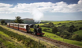
The West Somerset Railway (WSR) is a 22.75-mile (36.6 km) heritage railway line in Somerset, England. The freehold of the line and stations is owned by Somerset Council. The railway is leased to and operated by West Somerset Railway plc, which is supported and minority-owned by the West Somerset Railway Association (WSRA) charitable trust and the West Somerset Railway Heritage Trust (WSRHT). WSR operates services using both heritage steam and diesel trains.

<span class="mw-page-title-main">South West Coast Path</span> Long-distance footpath in England

The South West Coast Path is England's longest waymarked long-distance footpath and a National Trail. It stretches for 630 miles (1,014 km), running from Minehead in Somerset, along the coasts of Devon and Cornwall, to Poole Harbour in Dorset. Because it rises and falls with every river mouth, it is also one of the more challenging trails. The total height climbed has been calculated to be 114,931 ft (35,031 m), almost four times the height of Mount Everest. It has been voted 'Britain's Best Walking route' twice in a row by readers of The Ramblers' Walk magazine, and regularly features in lists of the world's best walks.

<span class="mw-page-title-main">Exmoor</span> National park in South West England

Exmoor is loosely defined as an area of hilly open moorland in west Somerset and north Devon in South West England. It is named after the River Exe, the source of which is situated in the centre of the area, two miles north-west of Simonsbath. Exmoor is more precisely defined as the area of the former ancient royal hunting forest, also called Exmoor, which was officially surveyed 1815–1818 as 18,810 acres (7,610 ha) in extent. The moor has given its name to a National Park, which includes the Brendon Hills, the East Lyn Valley, the Vale of Porlock and 55 km (34 mi) of the Bristol Channel coast. The total area of the Exmoor National Park is 692.8 km2 (267.5 sq mi), of which 71% is in Somerset and 29% in Devon.

<span class="mw-page-title-main">Lynton</span> Town in Devon, England

Lynton is a town on the Exmoor coast in the North Devon district in the county of Devon, England, approximately 17 miles (27 km) north-east of Barnstaple and 18 miles (29 km) west of Minehead, and close to the confluence of the West Lyn and East Lyn rivers. Lynton sits directly above the neighbouring village of Lynmouth; the two settlements are separated by a steep gorge.

<span class="mw-page-title-main">North Devon</span> Non-metropolitan district in England

North Devon is a local government district in Devon, England. Its council is based just outside Barnstaple, the district's largest town. The district also includes the towns of Ilfracombe, Lynton and Lynmouth and South Molton along with numerous villages, seaside resorts and surrounding rural areas.

<span class="mw-page-title-main">Lynmouth</span> Village in Devon, England

Lynmouth is a village in Devon, England, on the northern edge of Exmoor. The village straddles the confluence of the West Lyn and East Lyn rivers, in a gorge 700 feet (210 m) directly below the neighbouring town of Lynton, which was the only place to expand to once Lynmouth became as built-up as possible. The villages are connected by the Lynton and Lynmouth Cliff Railway, which works two cable-connected cars by gravity, using water tanks.

<span class="mw-page-title-main">A361 road</span> Longest three-digit road in England

The A361 is an A class road in southern England, which at 195 miles (314 km) is the longest three-digit A road in the UK.

<span class="mw-page-title-main">Porlock</span> Human settlement in England

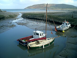
Porlock is a coastal village in Somerset, England, 5 miles (8 km) west of Minehead. At the 2011 census, the village had a population of 1,440.

<span class="mw-page-title-main">Lynton and Barnstaple Railway</span> Narrow gauge railway in Devon, England

The Lynton and Barnstaple Railway (L&B) opened as an independent railway in May 1898. It was a single track, 1 ft 11+12 in narrow gauge railway and was slightly over 19 miles (31 km) long running through the rugged and picturesque area bordering Exmoor in North Devon, England. Although opened after the Light Railways Act 1896 came into force, it was authorised and constructed prior to that act. Therefore, as with all other railways, it was authorised under its own Act of Parliament and built to higher standards than similar railways of the time. In the United Kingdom it was notable as being the only narrow gauge line required to use main-line standard signalling. For a short period the line earned a modest return for shareholders, but for most of its life the L&B made a loss. In 1923, the L&B was taken over by the Southern Railway, and eventually closed in September 1935.

<span class="mw-page-title-main">Porlock Hill</span> Road in Exmoor, England

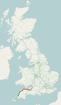
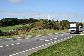
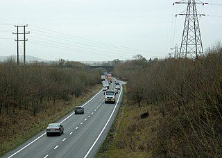
Porlock Hill is a road west of Porlock, Somerset. It is part of the A39, connecting Porlock to Lynmouth and Barnstaple in Devon and is the steepest A-road in the United Kingdom, approaching 1 in 4 (25%) in places. A toll road is available which connects the same two endpoints at the top and bottom of the hill at an easier gradient.

<span class="mw-page-title-main">Lynton and Lynmouth Cliff Railway</span> Water powered funicular in England

The Lynton and Lynmouth Cliff Railway is a water-powered funicular joining the twin towns of Lynton and Lynmouth on the rugged coast of North Devon in southwest England.

<span class="mw-page-title-main">Brendon</span> Village in Devon, England

Brendon is a village and former civil parish, now in the parish of Brendon and Countisbury, in the North Devon district, in the county of Devon, England. It is close to the border with Somerset within the Exmoor National Park, the village is 1.5 miles (2.4 km) southeast of Lynton and 15 miles (24 km) west of Minehead in the East Lyn Valley. It is located just off the A39 and is on two long distance footpaths, the Coleridge Way and the Samaritans Way South West. The Church of St Brendon is 2 mi (3 km) from the village and was built in 1738, possibly with building material brought from another site. In 2001 the parish had a population of 159.

<span class="mw-page-title-main">North Cornwall Railway</span> Disused railway line in Devon and Cornwall, England

The North Cornwall Railway (NCR) also known as the North Cornwall Line, was a standard gauge railway line running from Halwill in Devon, to Padstow in Cornwall, at a distance of 49 miles 67 chains via Launceston, Camelford and Wadebridge. The line was opened in late 19th century by the North Cornwall Railway Company with support throughout much of its construction and existence by the London and South Western Railway (LSWR).

<span class="mw-page-title-main">B roads in Zone 3 of the Great Britain numbering scheme</span>

B roads are numbered routes in Great Britain of lesser importance than A roads. See the article Great Britain road numbering scheme for the rationale behind the numbers allocated.

<span class="mw-page-title-main">Transport in Cornwall</span>

The evolution of transport in Cornwall has been shaped by the county's strong maritime, mining and industrial traditions and much of the transport infrastructure reflects this heritage.

<span class="mw-page-title-main">Quantock Motor Services</span> English bus operator

Quantock Motor Services is a privately owned bus operator in Bishops Lydeard, Somerset, England. The company operates a substantial heritage fleet for private hire and on route 300.

Lynmouth Lifeboat Station was the base for Royal National Lifeboat Institution (RNLI) search and rescue operations at Lynmouth, Devon in England from 1869 until 1944. Its best known action was in 1899 when the lifeboat was taken 15 miles (24 km) across Exmoor before being launched to assist a ship in trouble.

<span class="mw-page-title-main">Exmoor Group</span>

The Exmoor Group is a late Devonian to early Carboniferous lithostratigraphic group in southwest England whose outcrop extends from Croyde in north Devon east across Exmoor to Minehead in west Somerset. The group comprises the following formations :

<span class="mw-page-title-main">Lynton and Lynmouth</span> Area of Devon

Lynton and Lynmouth is a civil parish in the North Devon district of Devon, England. The parish is named after its two main settlements of Lynton, which stands on a plateau above the Glen Lyn Gorge, and Lynmouth which lies at the foot of the gorge where the West Lyn River and East Lyn River converge and then meet the sea. The two are connected by the Lynton and Lynmouth Cliff Railway, a water-powered funicular railway.

The geology of Exmoor National Park in south-west England contributes significantly to the character of Exmoor, a landscape which was designated as a national park in 1954. The bedrock of the area consists almost wholly of a suite of sedimentary rocks deposited during the Devonian, a period named for the English county of Devon in which the western half of the park sits. The eastern part lies within Somerset and it is within this part of the park that limited outcrops of Triassic and Jurassic age rocks are to be found.

References

  1. 1 2 "Porlock Hill". Rural Roads. Retrieved 3 April 2009.
  2. Leete-Hodge, Lornie (1985). Curiosities of Somerset. Bodmin: Bossiney Books. p. 45. ISBN   0-906456-98-3.
  3. "Overland Launch Overnight January 12th. /13th.1899". Lynton & Lynmouth. Archived from the original on 12 October 2010. Retrieved 3 April 2009.
  4. "Woody Bay Station - Lynton". Lynton & Barnstaple Railway. Archived from the original on 30 January 2009. Retrieved 3 April 2009.
  5. "Official Naming Ceremony For Atlantic Highway". Cornwall County Council. Archived from the original on 30 September 2007. Retrieved 28 October 2007.
  6. "The "Atlantic Highway" – Naming History". Atlantic Highway. Archived from the original on 24 March 2009. Retrieved 3 April 2009.