
A roads are numbered routes in Great Britain. See the article Great Britain road numbering scheme for the rationale behind the numbers allocated.
Depending on the first digit of the road's number see:
B roads are numbered routes in Great Britain of lesser importance than A roads. See the article Great Britain road numbering scheme for the rationale behind the numbers allocated.
Depending on the first digit of the road's number see:
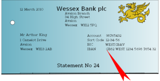
The International Bank Account Number (IBAN) is an internationally agreed system of identifying bank accounts across national borders to facilitate the communication and processing of cross border transactions with a reduced risk of transcription errors. An IBAN uniquely identifies the account of a customer at a financial institution. It was originally adopted by the European Committee for Banking Standards (ECBS) and later as an international standard under ISO 13616:1997. The current standard is ISO 13616:2020, which indicates SWIFT as the formal registrar. Initially developed to facilitate payments within the European Union, it has been implemented by most European countries and numerous countries in other parts of the world, mainly in the Middle East and the Caribbean. As of May 2020, 77 countries were using the IBAN numbering system.

A postal code is a series of letters or digits or both, sometimes including spaces or punctuation, included in a postal address for the purpose of sorting mail.

The Great Britain road numbering scheme is a numbering scheme used to classify and identify all roads in Great Britain. Each road is given a single letter and a subsequent number. Introduced to arrange funding allocations, the numbers soon became used on maps and as a method of navigation. Two sub-schemes exist: one for motorways, and another for non-motorway roads. While some major roads form part of the International E-road network, no E-routes are signposted in Great Britain, or the rest of the UK. Due to changes in local road designation, in some cases roads are numbered out of zone. There are also instances where road numbers in one area are also found in another location. For example the A594 is designated as the Leicester Ring Road and also allocated to a road in Cumbria.

The National Cycle Network (NCN) is the national cycling route network of the United Kingdom, which was established to encourage cycling and walking throughout Britain, as well as for the purposes of bicycle touring. It was created by the charity Sustrans who were aided by a £42.5 million National Lottery grant. In 2017, the Network was used for over 786 million cycling and walking trips.

The director telephone system was a development of the Strowger or step-by-step (SXS) switching system used in London and five other large cities in the UK from the 1920s to the 1980s.
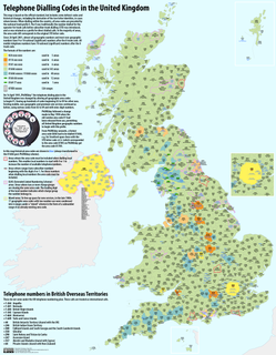
Telephone numbers in the United Kingdom are administered by the Office of Communications (Ofcom). For this purpose, Ofcom established a telephone numbering plan, known as the National Telephone Numbering Plan, which is the system for assigning telephone numbers to subscriber stations.
The Australian telephone numbering plan describes the allocation of phone numbers in Australia. It has changed many times, the most recent major reorganisation by the Australian Communications and Media Authority taking place between 1994 and 1998.
The Southern Railway created classification and numbering systems for its large fleet of electric multiple units, perpetuated by the Southern Region of British Rail until the early 1980s, when the impact of TOPS was felt. Some stock is still allocated Southern-style classifications in a semi-official manner.
A routenumber, designation or abbreviation is an identifying numeric designation assigned by a highway authority to a particular stretch of roadway to distinguish it from other routes and, in many cases, also to indicate its classification, general geographical location and/or orientation. The numbers chosen may be used solely for internal administrative purposes; however, in most cases they are also displayed on roadside signage and indicated on maps.
In the Great Britain road numbering scheme, the country is divided into numbered zones, the boundaries of which are usually defined by single-digit roads. The first digit of a road's number should be the number of the zone it occupies. If the road occupies multiple zones, then the furthest-anticlockwise zone is the correct one. The following tables list all British roads which are anomalously numbered. Roads in bold lie completely outside their "correct" zone; all other roads run for some length in their "correct" zones but trespass into zones anticlockwise of this zone. A further table lists duplicated road numbers.

The International Article Number is a standard describing a barcode symbology and numbering system used in global trade to identify a specific retail product type, in a specific packaging configuration, from a specific manufacturer. The standard has been subsumed in the Global Trade Item Number standard from the GS1 organization; the same numbers can be referred to as GTINs and can be encoded in other barcode symbologies defined by GS1. EAN barcodes are used worldwide for lookup at retail point of sale, but can also be used as numbers for other purposes such as wholesale ordering or accounting. These barcodes only represent the digits 0–9, unlike some other barcode symbologies which can represent additional characters.
B roads are numbered routes in Great Britain of lesser importance than A roads. See the article Great Britain road numbering scheme for the rationale behind the numbers allocated.
B roads are numbered routes in Great Britain of lesser importance than A roads. See the article Great Britain road numbering scheme for the rationale behind the numbers allocated.
B roads are numbered routes in Great Britain of lesser importance than A roads. See the article Great Britain road numbering scheme for the rationale behind the numbers allocated.
B roads are numbered routes in Great Britain of lesser importance than A roads. See the article Great Britain road numbering scheme for the rationale behind the numbers allocated.
B roads are numbered routes in Great Britain of lesser importance than A roads. See the article Great Britain road numbering scheme for the rationale behind the numbers allocated.
B roads are numbered routes in Great Britain of lesser importance than A roads. See the article Great Britain road numbering scheme for the rationale behind the numbers allocated.
B roads are numbered routes in Great Britain of lesser importance than A roads. See the article Great Britain road numbering scheme for the rationale behind the numbers allocated.
B roads are numbered routes in Great Britain of lesser importance than A roads. See the article Great Britain road numbering scheme for the rationale behind the numbers allocated.