Concurrency (road)

Last updated
An extreme example: I-40, I-85 Business, US 29, US 70, US 220, and US 421 formerly ran concurrently in Greensboro, North Carolina. In 2008, I-40 was rerouted off this road but was put back on it later that same year with US 220 being rerouted instead. US 421 was also rerouted in 2009. Greensboro road signs.jpg
An extreme example: I-40, I-85 Business, US 29, US 70, US 220, and US 421 formerly ran concurrently in Greensboro, North Carolina. In 2008, I-40 was rerouted off this road but was put back on it later that same year with US 220 being rerouted instead. US 421 was also rerouted in 2009.

A concurrency in a road network is an instance of one physical roadway bearing two or more different route numbers. [1] When two roadways share the same right-of-way, it is sometimes called a common section or commons. [2] Other terminology for a concurrency includes overlap, [3] coincidence, [4] duplex (two concurrent routes), triplex (three concurrent routes), multiplex (any number of concurrent routes), [5] dual routing or triple routing. [6] [7]

Contents

Concurrent numbering can become very common in jurisdictions that allow it. Where multiple routes must pass between a single mountain crossing or over a bridge, or through a major city, it is often economically and practically advantageous for them all to be accommodated on a single physical roadway. In some jurisdictions, however, concurrent numbering is avoided by posting only one route number on highway signs; these routes disappear at the start of the concurrency and reappear when it ends. However, any route that becomes unsigned in the middle of the concurrency will still be signed on most maps and road atlases.

Overview

Most concurrencies are simply a combination of at least two route numbers on the same physical roadway. This is often practically advantageous as well as economically advantageous; it may be better for two route numbers to be combined into one along rivers or through mountain valleys. Some countries allow for concurrencies to occur, however, others specifically do not allow it to happen. In those nations which do permit concurrencies, it can become very common. In these countries, there are a variety of concurrences which can occur.

An example of this is the concurrency of Interstate 70 (I-70) and I-76 on the Pennsylvania Turnpike in western Pennsylvania. I-70 merges with the Pennsylvania Turnpike so the route number can ultimately continue east into Maryland; instead of having a second physical highway built to carry the route, it is combined with the Pennsylvania Turnpike and the I-76 designation. [8] A triple Interstate concurrency is found in Wisconsin along the five-mile (8.0 km) section of I-41, I-43, and I-894 in Milwaukee, Wisconsin. [9] The concurrency of I-41 and I-43 on this roadway is an example of a wrong-way concurrency.

The longest Interstate highway concurrency is I-80 and I-90 for 278 miles (447 km) across Indiana and Ohio, while the longest Interstate highway concurrency with three interstates is I-39, I-90, and I-94 in Portage, Wisconsin for over 29 miles (47 km). [10]

There are at least two examples of eight-way concurrencies. The first example is in Indianapolis, between exits 46 and 47 of the 53-mile (85 km) I-465 beltway, where the highway is concurrent with U.S. Route 31 (US 31), US 36, US 40, US 52, US 421, State Road 37 (SR 37), and SR 67. [11] Once I-69 is extended south of Indianapolis, this segment will have a nine-way concurrency. The second example is in downtown Athens, Georgia, between exits 4 and 8 of Georgia State Route 10 Loop, where the highway is concurrent with US 29, US 78, US 129, US 441, State Route 8 (SR 8), SR 15, and SR 422. [12]

Regional examples

North America

The Queen Elizabeth Way concurrent with Highway 403 in Ontario QEW and Hwy 403 Concurrency.jpg
The Queen Elizabeth Way concurrent with Highway 403 in Ontario

In the United States, concurrencies are simply marked by placing signs for both routes on the same or adjacent posts. The federal Manual on Uniform Traffic Control Devices prescribes that when mounting these adjacent signs together that the numbers will be arranged vertically or horizontally in order of precedence. The order to be used is Interstate Highways, U.S. Highways, state highways, and finally county roads, and within each class by increasing numerical value. [13]

Several states do not officially have any concurrencies, instead officially ending routes on each side of one. [lower-alpha 1] There are several circumstances where unusual concurrencies exist along state borders. One example occurs along the OklahomaArkansas state line. At the northern end of this border Oklahoma State Highway 20 runs concurrently with Arkansas Highway 43 and the two highways run north–south along the boundary. [15]

A section of Ontario Highway 400 runs concurrent with a branch of the Trans-Canada Highway ON 400 TCH.jpg
A section of Ontario Highway 400 runs concurrent with a branch of the Trans-Canada Highway

Concurrencies are also found in Canada. British Columbia Highway 5 continues east for 12 kilometres (7.5 mi) concurrently with Highway 1 and Highway 97, through Kamloops. This stretch of road, which carries Highway 97 south and Highway 5 north on the same roadway (and vice versa), is the only wrong-way concurrency in British Columbia. Concurrencies are also very common in Quebec. Most notably, the Samuel-de-Champlain Bridge features a concurrency with three Autoroutes: A-10, A-15, and A-20. Another example is A-55, which runs concurrently with A-10, A-20, and A-40, all of which are major highways.

In Ontario, the Queen Elizabeth Way and Highway 403 run concurrently between Burlington and Oakville, forming the province's only concurrency between two 400-series highways. [16] The concurrency was not in the original plan which intended for both the QEW and Highway 403 to run parallel to each other, as the Hamilton–Brantford and Mississauga sections of Highway 403 were initially planned to be linked up along a corridor (later planned to be tolled) now occupied by Highway 407. To avoid forcing drivers to pay tolls to use a section of a continuous Highway 403, the new link was designated as a western extension of the tolled Highway 407, with the Mississauga section of Highway 403 planned to be renumbered as Highway 410. The renumbering to 410 never came to pass, [17] and consequently Highway 403 was signed concurrently along the Queen Elizabeth Way in 2002, remedying the discontinuity. Nonetheless, many surface street signs referring to that section of freeway with the QEW/Highway 403 concurrency still only use the highway's original designation of QEW, although the MTO has updated route markers on the QEW to reflect the concurrency. [18]

At the national level, the Trans-Canada Highway, which does not bear a uniform number in the eastern provinces, follows various provincial highways. In the Atlantic Provinces the main designated TCH route either follows a single numbered route across each province (an exception being the switching of the designation between Nova Scotia Highways 104 and 105), or has branches that are signed exclusively as TCH routes. In Ontario and Quebec, The TCH follows a series of provincial highways, and also has branches that follow sections of others that have concurrencies with it, signed with TCH shields alongside the provincial number.

Europe

Concurrency of the city beltway, a European road, and three first-class roads in Hradec Kralove, Czech Republic Labsky most, znacky silnic.jpg
Concurrency of the city beltway, a European road, and three first-class roads in Hradec Králové, Czech Republic
Concurrency of several cycling routes in Pisek, Czech Republic Pisek, Fugnerovo namesti a nabrezi 1. maje, znacka cyklotras.jpg
Concurrency of several cycling routes in Písek, Czech Republic

In the United Kingdom, routes do not run concurrently with others. Where this would normally occur, the roadway takes the number of only one of the routes (usually, but not always, the most important route), while the other routes are considered to have a gap and are signed in brackets (the equivalent of "to" signs in North America). An example is the meeting of the M60 and the M62 northwest of Manchester: the motorways coincide for the seven miles (11 km) between junctions 12 and 18 but the motorway between those points is only designated as the M60 (although in this case the same junction numbers would also apply to the M62). European route numbers as designated by UNECE may have concurrencies (for instance E15 and E30 around Greater London), but since the E-route numbers are unsigned and unused in the UK, the existence of these concurrencies is purely theoretical.

In Sweden and Denmark, the most important highways use only the European route numbers that have cardinal directions. In Sweden the European route E6 and E20 run concurrently for 280 kilometres (170 mi). In Denmark the E47 and E55 run concurrently for 157 kilometres (98 mi). There are more shorter concurrencies. There are two stretches in Sweden and Denmark where three European routes run concurrently; these are E6, E20 and E22 in Sweden, and E20, E47, and E55 in Denmark. Along all these concurrencies, all route numbers are posted with signs. [19]

In the Czech Republic, the European route numbers are only additional, and they are always concurrent with the state route numbering, usually highways or first-class roads. In the state numbering system, concurrences exist only in first-class and second-class roads; third class roads do not have them. The local term for such concurrences is peáž (from the French word péage). In the road register, one of the roads is considered the main ("source") road and the others as the péaging (guest) roads. The official road map enables a maximum of five concurrent routes of the intrastate numbering system. [20] Cycling routes and hiking routes are often concurrent.

The Middle East

In Israel, two freeways, the Trans-Israel Highway (Highway 6), and Highway 1 run concurrently just east of Ben Shemen Interchange. The concurrency is officially designated "Daniel Interchange", providing half of the possible interchange directions. It is a one-mile (1.6 km) segment consisting of eight lanes providing high-speed access between the two highways. Access from Highway 1 west to Highway 6 south and Highway 6 north to Highway 1 east is provided via Route 431, while access between Highway 1 east to Highway 6 north and Highway 6 south to Highway 1 west are provided at Ben Shemen Interchange. The other movements are provided through the concurrency. [21]

Wrong-way concurrencies

This westbound highway in southwestern Virginia simultaneously carries I-77 and I-81 in opposite directions. The wrong-way concurrency is also reflected in US 52 and US 11, which are concurrent with I-77 and I-81, respectively. NB77SB81.JPG
This westbound highway in southwestern Virginia simultaneously carries I-77 and I-81 in opposite directions. The wrong-way concurrency is also reflected in US 52 and US 11, which are concurrent with I-77 and I-81, respectively.
An example of a wrong-way concurrency in Oklahoma City, Oklahoma; the wrong-way concurrency is highlighted in red. OKC wrongway.svg
An example of a wrong-way concurrency in Oklahoma City, Oklahoma; the wrong-way concurrency is highlighted in red.

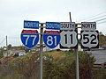
Since highways in the United States and Canada are usually signed with assigned cardinal directions based on their primary orientation, it is possible for a stretch of roadway shared between two highways to be signed with conflicting, even opposite, cardinal directions in a wrong-way concurrency.[ citation needed ] For example, near Wytheville, Virginia, there is a concurrency between Interstate 77 (which runs primarily north–south, as it is signed) and Interstate 81 (which runs primarily northeast–southwest, but is also signed north–south). A vehicle might simultaneously be on I-77 northbound and I-81 southbound, while actually traveling due westbound. [22] An unusual example of a three-directional concurrency occurs southeast of Rhinelander, Wisconsin, where US 8 westbound (the actual compass direction) converges with southbound Wisconsin Highway 17 and northbound Wisconsin Highway 47.[ citation needed ]

An example of a letter-suffixed wrong-way concurrency which is technically in four cardinal directions, is in Knoxville, Tennessee, where southbound US 11E converges with northbound US 25W and westbound US 70 (which is the real compass direction).[ citation needed ]

Effect on exit numbers

Often when two routes with exit numbers overlap, one of the routes has its exit numbers dominate over the other and can sometimes result in having two exits of the same number, albeit far from each other along the same highway. An example of this is from the concurrency of I-94 and US 127 near Jackson, Michigan. The concurrent section of freeway has an exit with M-106, which is numbered exit 139 using I-94's mileage-based numbers. US 127 also has another exit 139 with the southern end of the US 127 business loop in Mount Pleasant, Michigan. (US 127's mile markers in Michigan reflect the cumulative distance north of the Ohio state line; the numbers resume north of the I-94 overlap and reflect the distance accumulated on that concurrency.) [23]

However, there are also instances where the dominant exit number range is far more than the secondary route's highest exit number, for example the concurrency of I-75 and I-85 in Atlanta, Georgia — where I-75 is dominant — the exit numbers range from 242 to 251, while I-85's highest independent mile marker in Georgia is 179. [24]

Consolidation plans

US 1/9 concurrency signed on one shield NJ guide sign.jpg
US 1/9 concurrency signed on one shield

Some brief concurrencies in the past have been eliminated by reassigning the designations along the roadways. This can involve scaling back the terminus of one designation to the end of a concurrent section. At the same time, there could be an extension of another highway designation that is used to replace the newly shortened designation with another one.

Between states, US 27 in Michigan previously ran concurrently with I-69 from the Michigan–Indiana state line to the Lansing, Michigan, area. From there it turned northwards to its terminus at Grayling. In 1999, the Michigan and Indiana departments of transportation petitioned the American Association of State Highway and Transportation Officials for permission to truncate US 27 at Fort Wayne, Indiana. [25] In 2002, Michigan removed the US 27 designation from I-69 and extended the US 127 designation from Lansing to Grayling. [26] MDOT's stated reason for the modification was to "reduce confusion along the US 27/US 127 corridor". [27] After US 27's signage was removed, the highway north of the Lansing area was renumbered US 127, and the US 27 designation was removed from I-69. [27]

Some consolidation schemes involve the use of incorporating two single-digit numbers onto one marker, as along the US 1/9 concurrency in northern New Jersey. [28] In the mid-20th century, California had numerous concurrencies, but the California Legislature removed most of them in a comprehensive reform of highway numbering in 1964. [29]

See also

Notes

  1. Arkansas's highways exist in many officially designated "sections" rather than form concurrencies. Arkansas Highway 131 exists in five sections as an example. [14]

Related Research Articles

<span class="mw-page-title-main">Interstate 196</span> Interstate Highway in Michigan

Interstate 196 (I-196) is an auxiliary Interstate Highway that runs for 80.6 miles (129.7 km) in the US state of Michigan. It is a state trunkline highway that links Benton Harbor, South Haven, Holland, and Grand Rapids. In Kent, Ottawa, and Allegan counties, I-196 is known as the Gerald R. Ford Freeway, or simply the Ford Freeway, after President Gerald Ford, who was raised in Grand Rapids and served Michigan in the House of Representatives for 25 years. This name generally refers only to the section between Holland and Grand Rapids. I-196 changes direction; it is signed as a north–south highway from its southern terminus to the junction with US Highway 31 (US 31) just south of Holland, and as an east–west trunkline from this point to its eastern terminus at an interchange with I-96, its parent highway. There are three business routes related to the main freeway. There are two business loops and one business spur that serve South Haven, Holland and the Grand Rapids areas. Another business spur for Muskegon had been designated relative to the I-196 number.

<span class="mw-page-title-main">Interstate 496</span> Interstate Highway in Eaton and Ingham counties in Michigan, United States

Interstate 496 (I-496) is an auxiliary Interstate Highway that passes through downtown Lansing in the US state of Michigan. Also a component of the State Trunkline Highway System, the freeway connects I-96 to the downtown area. It has been named the R.E. Olds Freeway for Ransom E. Olds, the founder of Oldsmobile and the REO Motor Car Company. I-496 runs east–west from I-96/I-69 near the downtown area and north–south along a section that runs concurrently with US Highway 127 (US 127). The trunkline also passes a former assembly plant used by Oldsmobile and runs along or crosses parts of the Grand and Red Cedar rivers.

<span class="mw-page-title-main">M-5 (Michigan highway)</span> State highway in Michigan, United States

M-5, commonly referred to as Grand River Avenue and the northern section as the Haggerty Connector, is a 27.9-mile-long (44.9 km) state trunkline highway in the Metro Detroit area of the US state of Michigan. The highway runs through suburbs in Oakland and Wayne counties in addition to part of Detroit itself. It starts in Commerce Township as a north–south divided highway and freeway called the Haggerty Connector and connects with Interstate 96 (I-96) in Novi. The freeway then turns southeasterly to bypass the suburb of Farmington as an east–west highway. The freeway ends on the southeast side of Farmington, and M-5 follows Grand River Avenue as boulevard into Detroit. The eastern terminus is at the five-way intersection between Grand River Avenue, Cass Avenue, and Middle Street in Downtown Detroit, where it had been extended to in May 2016 from an interchange with I-96 on the northwest side of the city. The trunkline passes between suburban residential subdivisions and along urban commercial areas while serving 17,200–68,800 vehicles on average each day.

<span class="mw-page-title-main">M-43 (Michigan highway)</span> State highway in Michigan, United States

M-43 is a state trunkline highway in the southwestern and central parts of the US state of Michigan. The highway runs from South Haven to Webberville along an indirect path through both rural areas and larger cities. The trunkline follows five overall segments: a southeasterly track from South Haven to Oshtemo Township, a northerly path to Plainwell, a southeasterly route to Richland, a northeasterly course to the Hastings area and an easterly route through the Lansing area.

<span class="mw-page-title-main">M-79 (Michigan highway)</span> State highway in Michigan, United States

M-79 is an east–west state trunkline highway in the central portion of Lower Peninsula of the U.S. state of Michigan. The western terminus is about three miles (4.8 km) southeast of Hastings at the junction with M-37 and the eastern terminus is in downtown Charlotte at the junction with M-50 and Business Loop Interstate 69 (BL I-69). It passes through Quimby and Nashville, where there is a junction with M-66. The entire highway is undivided surface road. It has no direct access with Interstate 69 (I-69), although a sign for the highway is located on southbound I-69 at exit 61.

<span class="mw-page-title-main">M-51 (Michigan highway)</span> State highway in Michigan, United States

M-51 is a north–south state trunkline highway in the southwestern portion of the US state of Michigan. The southern terminus is at a connection with State Road 933 across the Michigan–Indiana state line near South Bend, Indiana. From there the trunkline runs north through an interchange with US Highway 12 (US 12) into Niles along a route that was once part of Business US 12. North of Niles, the highway runs parallel to a river and a rail line through rural areas. The northern terminus is on Interstate 94 (I-94) west of Paw Paw.

<span class="mw-page-title-main">M-15 (Michigan highway)</span> State highway in Michigan, United States

M-15 is a north–south state trunkline highway in the US state of Michigan. The southern terminus is a junction with US Highway 24 (US 24) just south of Clarkston on the northwestern edge of the Detroit metropolitan area. The trunkline is a recreational route running north and northwest to the Tri-Cities area. The northern terminus is the junction with M-25 on the east side of Bay City. The total length is about 73+23 miles (118.6 km) between the two regions.

<span class="mw-page-title-main">M-108 (Michigan highway)</span> Former state highway in Emmet and Cheboygan counties in Michigan, United States

M-108 was a state trunkline highway in the US state of Michigan. The highway followed Nicolet Street, although some maps also labeled it as Mackinaw Highway. The road was on the boundary between Emmet and Cheboygan counties.

<span class="mw-page-title-main">M-17 (Michigan highway)</span> State highway in Washtenaw County, Michigan, United States

M-17 is a 6.390-mile-long (10.284 km) state trunkline highway in the U.S. state of Michigan, connecting the cities of Ypsilanti and Ann Arbor in Washtenaw County. It was once part of a highway that spanned the southern Lower Peninsula of Michigan before the creation of the U.S. Highway System in 1926. The designation once extended into downtown Detroit, but the eastern terminus was progressively scaled back in the late 1960s to the current location in Ypsilanti. The changes made to the highways in Washtenaw County spawned Business M-17, a business loop for 11 years between 1945 and 1956.

<span class="mw-page-title-main">Interstate 275 (Michigan)</span> Interstate Highway in Michigan, United States

Interstate 275 (I-275) is an auxiliary Interstate Highway in the US state of Michigan that acts as a western bypass of the Detroit metropolitan area. The Michigan Department of Transportation (MDOT) maintains the highway as part of the larger State Trunkline Highway System. The freeway runs through the western suburbs near Detroit Metropolitan Wayne County Airport, and crosses several rivers and rail lines in the area. The southern terminus is the interchange with I-75 near Newport, northeast of Monroe. MDOT considers the Interstate to run to an interchange with I-96, I-696 and M-5 on the Farmington Hills–Novi city line, running concurrently with I-96 for about five miles (8.0 km). This gives a total length of about 35.03 miles (56.38 km), which is backed up by official signage. According to the Federal Highway Administration (FHWA), the length is 29.97 miles (48.23 km) because that agency considers I-275 to end at the junction with I-96 and M-14 along the boundary between Livonia and Plymouth Township. All other map makers, like the American Automobile Association, Rand McNally and Google Maps follow MDOT's practice.

<span class="mw-page-title-main">M-80 (Michigan highway)</span> State highway in Chippewa County, Michigan, United States

M-80 is a state trunkline highway in the Upper Peninsula of the US state of Michigan. It runs from Kinross to M-129 near Donaldson. The highway serves the site of the former Kincheloe Air Force Base and the current Chippewa County International Airport. The designation has been used twice before on roads in the Lower Peninsula in the 1910s through 1930s while the current usage dates back to the mid-1990s.

<span class="mw-page-title-main">M-61 (Michigan highway)</span> State highway in Michigan, United States

M-61 is a state trunkline highway in the US state of Michigan that runs between Marion and Standish. The highway runs along the boundary area between Northern Michigan and Central Michigan in the Lower Peninsula. M-61 runs through rural forestland connecting several smaller communities together as it connects M-115, US Highway 127 (US 127), Interstate 75 (I-75) and US 23. Less than 10,000 vehicles a day use various segments of the roadway on average.

<span class="mw-page-title-main">U.S. Route 27 in Michigan</span> Former U.S. Highway in Michigan

US Highway 27 (US 27) is a part of the US Highway System that now runs from Miami, Florida, to Fort Wayne, Indiana. In the US state of Michigan, it was a north–south state trunkline highway that entered the state south of Kinderhook and ended south of Grayling. Its route consisted of a freeway concurrency with Interstate 69 (I-69) from the state line north to the Lansing area before it followed its own freeway facility northward to St. Johns. From there north to Ithaca, US 27 was an expressway before continuing as a freeway to a terminus south of Grayling.

<span class="mw-page-title-main">M-54 (Michigan highway)</span> State highway in Genesee and Saginaw counties in Michigan, United States

M-54 is a north–south state trunkline highway in the US state of Michigan that bypasses the city of Flint. It is named Dort Highway for much of its length, in honor of Flint carriage and automobile pioneer Josiah Dallas Dort. The portion from the north end of Dort Highway to Clio Road is part of the historic Saginaw Trail, and was also part of the old Dixie Highway. The modern highway runs for 30.276 miles (48.724 km) through Genesee and Saginaw counties from connections with Interstate 75 (I-75) near Grand Blanc on the south to Birch Run on the north. The highway serves mostly suburban and urban sections of the Flint area. Outside of the city, it also passes through agricultural areas in northern Genesee County and southeastern Saginaw County. It also shares a short east–west section with M-83 near Birch Run.

<span class="mw-page-title-main">M-36 (Michigan highway)</span> State highway in Ingham and Livingston counties in Michigan, United States

M-36 is a state trunkline highway in the Lower Peninsula of the US state of Michigan that runs in a west–east direction from Mason to Whitmore Lake. The trunkline connects US Highway 127 (US 127) south of Lansing and US 23 north of Ann Arbor. The highway connects several smaller communities in the rural areas along its route. M-36 also runs concurrently with two other roadways, sharing pavement with M-52 and County Road D-19. According to traffic surveys in 2010, between 650 and 15,300 vehicles used the highway on average each day.

<span class="mw-page-title-main">M-81 (Michigan highway)</span> State highway in Michigan, United States

M-81 is an east–west state trunkline highway in the Lower Peninsula of the US state of Michigan. The trunkline travels from the city of Saginaw at the junction with M-13 to the junction with M-53 east of Cass City over the county line in Greenleaf Township in northwestern Sanilac County in The Thumb area of the state. Outside of the cities and villages along its route, M-81 passes through mostly rural farm country. Near Saginaw it intersects the freeway that carries both Interstate 75 (I-75) and US Highway 23 (US 23) in an industrial area.

<span class="mw-page-title-main">M-83 (Michigan highway)</span> State highway in Saginaw County, Michigan, United States

M-83 is a north–south state trunkline highway in the Lower Peninsula of the US state of Michigan primarily serving as a link between Interstate 75/US Highway 23 (I-75/US 23) in Birch Run, including a short east–west section with M-54, and the Bavarian-themed town of Frankenmuth. M-83 is primarily a north–south trunkline that passes by such landmarks as Bronner's Christmas Wonderland, Zehnder's and the Bavarian Inn before leaving town. The landscape in the remainder of the area is composed of farm fields between Frankenmuth and the northern terminus at M-15 near Richville.

<span class="mw-page-title-main">Business routes of Interstate 96</span> List of highways in Michigan

There have been six business routes of Interstate 96 (I-96) in the US state of Michigan. There are two business loops designated Business Loop Interstate 96 : one through Lansing and one through Howell. Both follow the old route of US Highway 16 (US 16), with appropriate connections to I-96. There are three former business spurs that were designated Business Spur Interstate 96. One connected to the carferry docks in Muskegon, running concurrently with part of Business US 31 along former US 16, but it has been eliminated. The second spur ran into downtown Portland until it was decommissioned in 2007. Two routes in the Detroit area—a loop through Farmington and a spur into Detroit—both using Grand River Avenue, and meeting at the temporary end of I-96 near Purdue Avenue, were eliminated when I-96 was moved to the completed Jeffries Freeway in 1977. The Farmington business route is still state-maintained as an unsigned highway, while the Detroit business route remained unsigned until it was decommissioned in 2016 and replaced by an extension of M-5.

<span class="mw-page-title-main">Michigan State Trunkline Highway System</span> Highway system in Michigan

The State Trunkline Highway System consists of all the state highways in Michigan, including those designated as Interstate, United States Numbered, or State Trunkline highways. In their abbreviated format, these classifications are applied to highway numbers with an I-, US, or M- prefix, respectively. The system is maintained by the Michigan Department of Transportation (MDOT) and comprises 9,669 miles (15,561 km) of trunklines in all 83 counties of the state on both the Upper and Lower peninsulas, which are linked by the Mackinac Bridge. Components of the system range in scale from 10-lane urban freeways with local-express lanes to two-lane rural undivided highways to a non-motorized highway on Mackinac Island where cars are forbidden. The longest highway is nearly 400 miles (640 km) long, while the shortest is about three-quarters of a mile. Some roads are unsigned highways, lacking signage to indicate their maintenance by MDOT; these may be remnants of highways that are still under state control whose designations were decommissioned or roadway segments left over from realignment projects.

References

  1. Esri (March 4, 2014). "Realigning Concurrent Routes". ArcGIS Help 10.2 & 10.2.1. Esri. Retrieved April 8, 2014.
  2. "Freeway Flaws: Fixing Them May Take Decades". Star Tribune . Minneapolis. June 3, 2005. common sections ... 2 freeways share a single right-of-way
  3. Esri (December 19, 2012). "Realigning Overlapping Routes". ArcGIS Resource Center. Esri. Retrieved April 8, 2014.
  4. Office of Highway System Engineering (August 1995). "State Highway Routes Selected Information, 1994 with 1995 Revisions" (PDF). California Department of Transportation. Route 3. Archived from the original (PDF) on March 16, 2007. Retrieved March 7, 2012. Coincident with Rte 299
  5. Reichard, Timothy. "Guide to Highway Multiplexes". Central PA/MD Roads. Retrieved April 8, 2014.
  6. Kanillopoolos, John J. (October 19, 1982). "Dual and Triple Routing on State Trunklines". Letter to Trunkline Numbering Committee. Lansing: Michigan Department of Transportation. Retrieved June 3, 2019 via Wikisource.
  7. Kanillopoolos, John J. (March 17, 1983). "Dual and Triple Routing on State Trunklines". Letter to Trunkline Numbering Committee. Lansing: Michigan Department of Transportation. Retrieved June 3, 2019 via Wikisource.
  8. Pennsylvania Department of Transportation Geographic Information Section (2010). Tourism & Transportation Map (Map). Scale not given. Harrisburg: Pennsylvania Department of Transportation. §§ E10–L11.
  9. Srubas, Paul (April 9, 2015). "It's Officially Interstate 41 Now in Wisconsin". Green Bay Press-Gazette . Retrieved May 27, 2015.
  10. Federal Highway Administration (December 31, 2013). "Table 1: Main Routes of the Dwight D. Eisenhower National System of Interstate and Defense Highways as of December 31, 2013". Route Log and Finder List. Federal Highway Administration. Retrieved April 8, 2014.
  11. Indiana Department of Transportation (2007). Indiana Transportation Map (Map) (2007–08 ed.). Scale not given. Indianapolis: Indiana Department of Transportation. Indianapolis inset.
  12. Georgia Department of Transportation (2021). General Highway Map, Clarke County, Georgia (PDF) (Map). 1:31,680.
  13. Federal Highway Administration (2009). "Chapter 2D. Guide Signs: Conventional Roads, §2D.29: Route Sign Assemblies" (PDF). Manual on Uniform Traffic Control Devices (Revisions 1&2, 2009 ed.). Washington, DC: Federal Highway Administration. p. 148. ISBN   9781615835171 . Retrieved December 20, 2014.
  14. Planning and Research Division (April 2010). State Highways 2009 (Database). Arkansas State Highway and Transportation Department. Archived from the original (ZIP) on July 7, 2011. Retrieved April 11, 2011.
  15. Arkansas State Highway and Transportation Department Planning and Research Division (2010). State Highway Map (Map). 1:950,400. Little Rock: Arkansas State Highway and Transportation Department. § A1.
  16. Ministry of Transportation of Ontario Geomatics Office (2010). Official Road Map / Carte Routière (Map) (2010–11 ed.). 1:250,000 (in English and French). Toronto: Ministry of Transportation of Ontario. § R25.
  17. Mitchell, Bob (April 6, 1995). "Rae Announces 407 Extension". Toronto Star. p. BR03.
  18. "Signs of the Times". Milestones. Ontario Good Roads Association. 2 (1): 26, 31. February 2002. Archived from the original on April 26, 2012. Retrieved January 2, 2012.
  19. Check Google Streetview at 55°33′00″N13°03′06″E / 55.5500993°N 13.0517037°E , 55°34′48″N12°15′42″E / 55.5800398°N 12.2615534°E and neighboring locations[ full citation needed ]
  20. "Číslo peažující silnice], explanatory notes to the road map, Ředitelství silnic a dálnic" (in Czech). Directorate of Roads and Highways. Archived from the original on 2015-05-18. Retrieved 2015-05-17.[ full citation needed ]
  21. עורכת אחראית אלנה בלינקי; Elena Belinki (2014). 2014 אטלס הזהב [Atlas HaZahav 2014] (in Hebrew) (9th ed.). מפה הוצאה לאור [Mapa Publishing]. ISBN   978-965-521-136-8. Archived from the original on 2014-07-14. Retrieved 2014-06-08.
  22. Virginia Department of Transportation (2012). Official State Transportation Map (Map) (2012–14 ed.). c. 1:832,680. Richmond: Virginia Department of Transportation. §§ F6–G6.
  23. Michigan Department of Transportation (2013). Pure Michigan: State Transportation Map (Map). c. 1:975,000. Lansing: Michigan Department of Transportation. §§ J10, M11. OCLC   42778335, 861227559.
  24. Georgia Department of Transportation (2011). Official Highway and Transportation Map (PDF) (Map) (2011–2012 ed.). Scale not given. Atlanta: Georgia Department of Transportation. Main map, §§ B1, I2; Atlanta inset, § E5. OCLC   770217845.
  25. Special Committee on U.S. Route Numbering (April 17, 1999). "Report of the Special Committee on U.S. Route Numbering to the Standing Committee on Highways" (PDF) (Report). Washington, DC: American Association of State Highway and Transportation Officials. Archived from the original (PDF) on October 16, 2017. Retrieved May 24, 2008.
  26. Ranzenberger, Mark (April 27, 2008). "US 127 Signs Getting Updated" . The Morning Sun . Mount Pleasant, MI. pp. 1A, 6A. OCLC   22378715 . Retrieved August 23, 2012 via NewsBank.
  27. 1 2 Debnar, Kari & Bott, Mark (January 14, 2002). "US 27 Designation Soon To Be Deleted from Michigan Highways" (PDF) (Press release). Michigan Department of Transportation.
  28. New Jersey Department of Transportation. Signage for US 1/9, NJ 21, US 22, and I-78 (Highway guide sign). Newark, NJ: New Jersey Department of Transportation. Retrieved December 5, 2009.
  29. "Route Renumbering: New Green Markers Will Replaces Old Shields" (PDF). California Highways and Public Works. 43 (1–2): 11–14. March–April 1964. ISSN   0008-1159 . Retrieved March 8, 2012.

Commons-logo.svg Media related to Concurrency at Wikimedia Commons