Traffic comprises pedestrians, vehicles, ridden or herded animals, trains, and other conveyances that use public ways (roads/sidewalks) for travel and transportation.

Route 45 is a state highway in the southern part of New Jersey. It runs 28.51 mi (45.88 km) from Route 49 in Salem, Salem County, northeast to U.S. Route 130 in Westville, Gloucester County. The route is signed as a north-south highway. Much of the southern part of the route runs through rural areas of Salem and Gloucester counties, passing through the communities of Woodstown and Mullica Hill. North of Mullica Hill, Route 45 runs through suburban areas, with the portion of the route between the northern border of Mantua Township and the southern border of Woodbury a four-lane divided highway. The route intersects many highways, including US 40 in Woodstown, Route 77 and US 322 in Mullica Hill, and Interstate 295 (I-295) in West Deptford Township.

Route 47 is a state highway in the southern part of New Jersey. It runs 75.20 mi (121.02 km) from Atlantic Avenue in Wildwood, Cape May County, north to U.S. Route 130 in Brooklawn, Camden County. It is also referred to as Delsea Drive, as it connects the Delaware River near Brooklawn to the Atlantic Ocean in Wildwood. This name was assigned by the New Jersey Legislature in 1933. The route runs through rural areas of Cape May and southern Cumberland counties as a two-lane road. Traffic jams along this portion of Route 47 are commonplace in the summer vacation season and can stretch for miles due to the missing southern section of Route 55, where all Jersey Shore-bound traffic enters the small two-lane road. North of here, the route runs through the cities of Millville and Vineland before entering Gloucester County, where it passes through more rural areas as well as Clayton and Glassboro. Past Glassboro, it heads through suburban areas in Washington and Deptford townships before running through Westville and Brooklawn. Route 47 is the longest signed state route in New Jersey.

An intersection or an at-grade junction is a junction where two or more roads converge, diverge, meet or cross at the same height, as opposed to an interchange, which uses bridges or tunnels to separate different roads. Major intersections are often delineated by gores and may be classified by road segments, traffic controls and lane design.

A three-way junction is a type of road intersection with three arms. A Y junction generally has three arms of equal size coming at an acute or obtuse angle to each other; while a T junction also has three arms, but one of the arms is generally a smaller road joining a larger road at right angle.

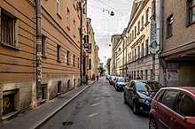
A street is a public thoroughfare in a built environment. It is a public parcel of land adjoining buildings in an urban context, on which people may freely assemble, interact, and move about. A street can be as simple as a level patch of dirt, but is more often paved with a hard, durable surface such as tarmac, concrete, cobblestone or brick. Portions may also be smoothed with asphalt, embedded with rails, or otherwise prepared to accommodate non-pedestrian traffic.
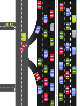
A frontage road is a local road running parallel to a higher-speed, limited-access road. A frontage road is often used to provide access to private driveways, shops, houses, industries or farms. Where parallel high-speed roads are provided as part of a major highway, these are also known as local lanes. Sometimes a similar arrangement is used for city roads; for example, the collector portion of Commonwealth Avenue in Boston, Massachusetts, is known as a carriage road.

The road hierarchy categorizes roads according to their functions and capacities. While sources differ on the exact nomenclature, the basic hierarchy comprises freeways, arterials, collectors, and local roads. Generally, the functional hierarchy can more or less correspond to the hierarchy of roads by their owner or administrator.

Lake Street is an east–west street in Chicago and part of its suburbs. A portion of Lake Street is designated as U.S. Route 20. Lake Street begins in downtown Chicago and travels west to the eastern terminus of the Elgin Bypass around suburban Elgin. The street travels west through the city and then begins to travel in a northwest fashion through several suburbs. The street is a distance of roughly 34.4 miles (55.4 km).

The street hierarchy is an urban planning technique for laying out road networks that exclude automobile through-traffic from developed areas. It is conceived as a hierarchy of roads that embeds the link importance of each road type in the network topology. Street hierarchy restricts or eliminates direct connections between certain types of links, for example residential streets and arterial roads, and allows connections between similar order streets or between street types that are separated by one level in the hierarchy. By contrast, in many regular, traditional grid plans, as laid out, higher order roads are connected by through streets of both lower order levels. An ordering of roads and their classification can include several levels and finer distinctions as, for example, major and minor arterials or collectors.

A collector road or distributor road is a low-to-moderate-capacity road which serves to move traffic from local streets to arterial roads. Unlike arterials, collector roads are designed to provide access to residential properties. Rarely, jurisdictions differentiate major and minor collector roads, the former being generally wider and busier.

County Route 537 is a county highway in the U.S. state of New Jersey. The highway extends 66.22 miles (106.57 km) from Delaware Avenue in Camden to CR 11 in Oceanport. It is the state's fourth longest 500 series county route.

County Route 524 is a county highway in the U.S. state of New Jersey. The highway extends 39.90 miles (64.21 km) from the White Horse Circle in Hamilton Township to Route 71 in Spring Lake Heights.
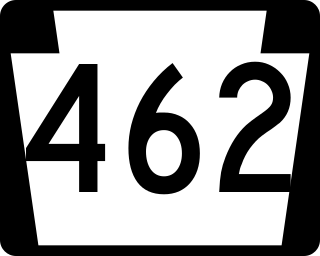
Pennsylvania Route 462 is a 32-mile-long (51 km) east–west state route in York and Lancaster counties in central Pennsylvania. The western terminus is west of York, and the eastern terminus is east of Lancaster. At both ends, PA 462 terminates at U.S. Route 30, which follows a mostly freeway alignment parallel to the north between York and Lancaster. The route heads east into York, where it follows the one-way pair of Market Street eastbound and Philadelphia Street westbound. In York, PA 462 runs concurrent with PA 74 and crosses Interstate 83 Business. East of York, the route becomes a multilane road that has an interchange with I-83 and crosses PA 24. PA 462 continues east through Hallam to Wrightsville and passes through that town before it crosses the Susquehanna River and runs through Columbia. East of here, the route continues through Mountville before reaching the city of Lancaster. In Lancaster, PA 462 is routed on the one-way pair of King Street eastbound and Walnut Street westbound, with the westbound direction concurrent with PA 23. The route crosses US 222/PA 272 and northbound PA 72 in Lancaster. East of Lancaster, PA 462 becomes a multilane road again and continues to its eastern terminus.

U.S. Route 1 (US 1) is the easternmost and longest of the major north–south routes of the older 1920s era United States Numbered Highway System, running from Key West, Florida, to Fort Kent, Maine. In the U.S. state of Maryland, it runs 81 miles (130 km) from the Washington, D.C. line to the Pennsylvania state line near the town of Rising Sun.

U.S. Route 231 (US 231) in Florida is a north–south United States Highway. It runs 52 miles (84 km) from Panama City north to the Alabama State Line in Bay and Jackson Counties. The entire route is also unsigned State Road 75, and is a four-lane highway throughout the state whether the road is divided or not.

An all-way stop – also known as a four-way stop – is a traffic management system which requires vehicles on all the approaches to a road intersection to stop at the intersection before proceeding through it. Designed for use at low traffic-volume locations, the arrangement is common in the United States, Canada, Mexico, South Africa, and Liberia, as well as in a number of, usually rural, locations in Australia where visibility on the junction approaches is particularly poor. The stop signs at such intersections may be supplemented with additional plates stating the number of approaches.

Terminology related to road transport—the transport of passengers or goods on paved routes between places—is diverse, with variation between dialects of English. There may also be regional differences within a single country, and some terms differ based on the side of the road traffic drives on. This glossary is an alphabetical listing of road transport terms.