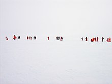
A blizzard is a severe snowstorm characterized by strong sustained winds and low visibility, lasting for a prolonged period of time—typically at least three or four hours. A ground blizzard is a weather condition where snow that has already fallen is being blown by wind. Blizzards can have an immense size and usually stretch to hundreds or thousands of kilometres.

Snow comprises individual ice crystals that grow while suspended in the atmosphere—usually within clouds—and then fall, accumulating on the ground where they undergo further changes. It consists of frozen crystalline water throughout its life cycle, starting when, under suitable conditions, the ice crystals form in the atmosphere, increase to millimeter size, precipitate and accumulate on surfaces, then metamorphose in place, and ultimately melt, slide or sublimate away.

Fog is a visible aerosol consisting of tiny water droplets or ice crystals suspended in the air at or near the Earth's surface. Fog can be considered a type of low-lying cloud usually resembling stratus and is heavily influenced by nearby bodies of water, topography, and wind conditions. In turn, fog affects many human activities, such as shipping, travel, and warfare.
Diamond dust is a ground-level cloud composed of tiny ice crystals. This meteorological phenomenon is also referred to simply as ice crystals and is reported in the METAR code as IC. Diamond dust generally forms under otherwise clear or nearly clear skies, so it is sometimes referred to as clear-sky precipitation. Diamond dust is most commonly observed in Antarctica and the Arctic, but can occur anywhere with a temperature well below freezing. In the polar regions of Earth, diamond dust may persist for several days without interruption.
The sky is an unobstructed view upward from the surface of the Earth. It includes the atmosphere and outer space. It may also be considered a place between the ground and outer space, thus distinct from outer space.
A winter storm is an event in which wind coincides with varieties of precipitation that only occur at freezing temperatures, such as snow, mixed snow and rain, or freezing rain. In temperate continental and subarctic climates, these storms are not necessarily restricted to the winter season, but may occur in the late autumn and early spring as well. A snowstorm with strong winds and low visibility is called a blizzard.

Haze is traditionally an atmospheric phenomenon in which dust, smoke, and other dry particulates suspended in air obscure visibility and the clarity of the sky. The World Meteorological Organization manual of codes includes a classification of particulates causing horizontal obscuration into categories of fog, ice fog, steam fog, mist, haze, smoke, volcanic ash, dust, sand, and snow. Sources for particles that cause haze include farming, traffic, industry, windy weather, volcanic activity and wildfires. Seen from afar and depending on the direction of view with respect to the Sun, haze may appear brownish or bluish, while mist tends to be bluish grey instead. Whereas haze often is considered a phenomenon occurring in dry air, mist formation is a phenomenon in saturated, humid air. However, haze particles may act as condensation nuclei that leads to the subsequent vapor condensation and formation of mist droplets; such forms of haze are known as "wet haze".
In meteorology, visibility is the measure of the distance at which an object or light can be clearly discerned. It depends on the transparency of the surrounding air and as such, it is unchanging no matter the ambient light level or time of day. It is reported within surface weather observations and METAR code either in meters or statute miles, depending upon the country. Visibility affects all forms of traffic: roads, railways, sailing and aviation.

A snow squall, or snowsquall, is a sudden moderately heavy snowfall with blowing snow and strong, gusty surface winds. It is often referred to as a whiteout and is similar to a blizzard but is localized in time or in location and snow accumulations may or may not be significant.

Ground blizzard refers to a weather condition where loose snow or ice on the ground is lifted and blown by strong winds. This can occur in the absence of precipitation, and can even occur when the sky is clear. This is in contrast to "ordinary" blizzards, which are accompanied by heavy falling snow. They can be especially dangerous as they occur after a winter storm has passed, when it is assumed that all forms of severe winter weather has ended.
This article describes severe weather terminology used by the Meteorological Service of Canada, a branch within Environment and Climate Change Canada. The article primarily describes various weather warnings, and their criteria. Related weather scales and general weather terms are also addressed in this article. Some terms are specific to certain regions.
Blowing snow is snow lifted from the surface by the wind, at eye level or more, that will reduce visibility. Blowing snow can come from falling snow or snow that already accumulated on the ground but is picked up and blown about by strong winds. It is one of the classic requirements for a blizzard. Its METAR code is BLSN. If the snow remains below 1.8 m (6 ft), it will be called drifting snow. The snow which is being blown about may deposit as snowdrifts.
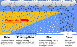
In meteorology, the different types of precipitation often include the character, formation, or phase of the precipitation which is falling to ground level. There are three distinct ways that precipitation can occur. Convective precipitation is generally more intense, and of shorter duration, than stratiform precipitation. Orographic precipitation occurs when moist air is forced upwards over rising terrain and condenses on the slope, such as a mountain.

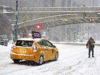
A blizzard warning is a hazardous weather statement issued by Weather Forecast Offices (WFO) of the National Weather Service (NWS) in the United States, which indicates heavy snowfall accompanied by sustained winds or frequent gusts of 35 mph (56 km/h) or greater are forecast to occur for a minimum of three hours. A blizzard tends to reduce visibilities to 1⁄4 mile (400 m) or less.
A blizzard watch was a bulletin issued by the National Weather Service of the United States which meant winds greater than 35 miles per hour, mixed with falling or blowing snow, and visibilities of 1⁄4 mile (0.4 km) or less is forecast for a period of 3 hours or more. A blizzard watch was issued 12 to 48 hours before an expected blizzard event. As the forecast solidifies, a blizzard watch would be either downgraded to a winter storm warning or winter weather advisory for blowing snow or upgraded to a blizzard warning.

Classifications of snow describe and categorize the attributes of snow-generating weather events, including the individual crystals both in the air and on the ground, and the deposited snow pack as it changes over time. Snow can be classified by describing the weather event that is producing it, the shape of its ice crystals or flakes, how it collects on the ground, and thereafter how it changes form and composition. Depending on the status of the snow in the air or on the ground, a different classification applies.
Atmospheric optics is "the study of the optical characteristics of the atmosphere or products of atmospheric processes .... [including] temporal and spatial resolutions beyond those discernible with the naked eye". Meteorological optics is "that part of atmospheric optics concerned with the study of patterns observable with the naked eye". Nevertheless, the two terms are sometimes used interchangeably.

This glossary of meteorology is a list of terms and concepts relevant to meteorology and atmospheric science, their sub-disciplines, and related fields.

Long-distance observation is any visual observation, for sightseeing or photography, that targets all the objects, visible from the extremal distance with the possibility to see them closely. The long-distance observations can't cover:

The January 2022 North American blizzard caused widespread and disruptive impacts to the Atlantic coast of North America from northern Delaware to Nova Scotia with as much as 2.5 feet (30 in) of snowfall, blizzard conditions and coastal flooding at the end of January 2022. Forming from the energy of a strong mid- to upper-level trough, the system developed into a low-pressure area off the Southeast United States on January 28. The system then quickly intensified that night as it traveled northeast parallel to the coast on January 29, bringing heavy snowfall blown by high winds to the upper East Coast of the continent. Further north, it also moved inland in Maine and its width meant it strongly impacted all three of Canada's Maritime provinces. In some areas, mainly the coastal regions due to the wind, areas of New Jersey, Long Island and Massachusetts, it was the first blizzard since a storm in January 2018. The storm was considered a "bomb cyclone" as it rapidly intensified and barometric pressure dropped at least 24 millibars over a 24-hour period. The storm was given names such as Blizzard of 2022 and Winter Storm Kenan.