Continuous-flow intersection

Last updated
Sample continuous-flow intersection with typical lane variation, turn restrictions, and traffic light position Continuous-flow intersection.svg
Sample continuous-flow intersection with typical lane variation, turn restrictions, and traffic light position
A continuous flow intersection in West Valley City, Utah showing the layout and normal traffic flow in the southwest portion of the intersection. Intersection continuous flow.jpg
A continuous flow intersection in West Valley City, Utah showing the layout and normal traffic flow in the southwest portion of the intersection.
Driving through a continuous flow intersection on Utah State Route 154 (Bangerter Highway) at 4100 South in summer 2013.

A continuous flow intersection (CFI), also called a crossover displaced left-turn (XDL or DLT), is an alternative design for an at-grade road junction. Vehicles attempting to turn across the opposing direction of traffic (left in right-hand drive jurisdictions; right in left-hand drive jurisdictions) cross before they enter the intersection. No left turn signal in the intersection is then necessary. Instead, vehicles traveling in both directions can proceed, including through vehicles and those turning right or left, when a generic traffic signal/stop sign permits.

Contents

Its design also is promoted as part of the Federal Highway Administration's Every Day Counts initiative which started in 2011. [1]

History

A fly-over designed CFI interchange (separated grade) was invented by Francisco Mier. An intersection (at-grade) variant followed. Over 40 have been implemented since 2000. Mier patented his design and required a fee to obtain a license to the design. [2] The patent expired in the United States on 15 October 2003. [3]

This general configuration has appeared in different versions in various places, with the implementation of channelization in the United States since the 1950s, such as the Telegraph Road section of U.S. Route 24 in Michigan at Plymouth Road in Redford Charter Township, Michigan. [4]

Map all coordinates using: OpenStreetMap

Usage

Australia

Canada

China

Germany

Mexico

United Kingdom

United States

A continuous flow intersection between Maryland Route 210 and Maryland Route 228 in Accokeek, Maryland. 2006 11 14 - 228@210 - WB CFI 1.JPG
A continuous flow intersection between Maryland Route 210 and Maryland Route 228 in Accokeek, Maryland.
Sketch and traffic light sequence of a four-way intersection with displaced left turns on two of the legs. Continuous-flow-intersection-cfi-4arm-2way-ani.gif
Sketch and traffic light sequence of a four-way intersection with displaced left turns on two of the legs.

Listed in chronological order:

  1. Haddon Township, City of Camden, New Jersey, New Jersey Route 168 at US Route 130, is a continuous flow intersection.
  2. Audubon and Audubon Park, New Jersey, New Jersey Route 168 at Nicholson Road, is a hybrid one-leg continuous flow intersection that also employs a jughandle.[ citation needed ] 39°53′39″N75°05′29″W / 39.894161°N 75.091435°W / 39.894161; -75.091435
  3. Shirley, New York, opened in 1996, at the entrance to Dowling College. [10] 40°49′35″N72°52′52″W / 40.826443°N 72.881042°W / 40.826443; -72.881042
  4. Accokeek, Maryland, opened in 2000, at the intersection of Routes 210 and 228. [10] This is an example of a CFI-T, which is a T intersection containing one CFI leg. This junction also has characteristics of a continuous green T (or seagull) intersection. [11] While neither of the routes is grade-separated, southbound through traffic on Route 210 is free-flowing. 38°39′51″N77°01′01″W / 38.664126°N 77.016928°W / 38.664126; -77.016928
  5. Baton Rouge, Louisiana, opened in March 2006, at the intersection of Airline Highway and Siegen Lane. [12] 30°23′56″N91°03′15″W / 30.398914°N 91.054119°W / 30.398914; -91.054119
  6. Along Utah State Route 154 (Bangerter Highway) at
    1. 5400 South (SR-173) in Taylorsville, 40°39′11″N111°58′53″W / 40.652993°N 111.981339°W / 40.652993; -111.981339
    2. 4700 South in Taylorsville and West Valley City, 40°40′03″N111°58′54″W / 40.667596°N 111.981567°W / 40.667596; -111.981567
    3. 4100 South in West Valley City, 40°40′56″N111°58′54″W / 40.682132°N 111.981626°W / 40.682132; -111.981626
    4. 3500 South (SR-171) in West Valley City, [13] opened in September 2007, [14] 40°41′48″N111°58′51″W / 40.696629°N 111.980869°W / 40.696629; -111.980869
    5. 3100 South in West Valley City, 40°42′14″N111°58′48″W / 40.703918°N 111.980076°W / 40.703918; -111.980076
  7. Fenton, Missouri, opened October 2007, [15] at the intersection of Highway 30 and Summit Drive/Gravois Bluffs Boulevard. [16] 38°30′15″N90°27′25″W / 38.504276°N 90.456995°W / 38.504276; -90.456995
  8. Miami Township, Montgomery County, Ohio, a two-leg CFI constructed in the spring of 2009, at the intersection of SR 741 and Miamisburg-Springboro Road/Austin Boulevard. [17] 39°35′48″N84°13′45″W / 39.596709°N 84.229029°W / 39.596709; -84.229029
  9. Salt Lake County, Utah, in October 2009, the Utah Department of Transportation announced plans for five more continuous flow intersections along Bangerter Highway and Redwood Road (SR-68). As of March 11, 2011, four of them were in use. [18]
    1. 13400 South and Bangerter Highway in Riverton, 40°30′28″N111°58′58″W / 40.507803°N 111.982747°W / 40.507803; -111.982747
    2. 7000 South and Bangerter Highway in West Jordan, 40°37′26″N111°58′35″W / 40.623983°N 111.976422°W / 40.623983; -111.976422
    3. 6200 South (Bennion Boulevard) and Bangerter Highway in Taylorsville, 40°38′19″N111°58′36″W / 40.638581°N 111.976637°W / 40.638581; -111.976637
    4. W 5400 S (SR-173) and Redwood Road in Taylorsville, 40°39′11″N111°56′20″W / 40.653176°N 111.938802°W / 40.653176; -111.938802
    5. 6200 South (Bennion Boulevard) and Redwood Road in Taylorsville, 40°38′19″N111°56′20″W / 40.638574°N 111.938824°W / 40.638574; -111.938824
  10. Natchez, Mississippi, opened January 2010 at the intersection of US 61 and Junkin Drive, designed by ABMB Engineers and constructed by MDOT. 31°31′43″N91°23′21″W / 31.528599°N 91.389213°W / 31.528599; -91.389213
  11. Lafayette, Louisiana, ground broke January 2010 at the intersection of US 167 (Johnston St.) and Camellia Boulevard. Estimated cost of $3.5 million. [19] 30°11′37″N92°03′31″W / 30.193744°N 92.058622°W / 30.193744; -92.058622
  12. Loveland, Colorado, ground broke June 2010 at the intersection of US 34 (Eisenhower Boulevard) and Madison Avenue. Estimated cost of $4 million. [20] 40°24′27″N105°03′32″W / 40.407365°N 105.058764°W / 40.407365; -105.058764
  13. Orem, Utah, opened May 22, 2012 at the intersection of University Parkway and Sandhill Road, as part of the Interstate 15 CORE project. [21] 40°16′30″N111°42′48″W / 40.275014°N 111.713445°W / 40.275014; -111.713445
  14. Durango, Colorado, at the intersection of US 160 and US 550. Estimated cost of $6.1 million. [22] 37°16′07″N107°53′06″W / 37.268540°N 107.884992°W / 37.268540; -107.884992
  15. Laurel, Maryland, at the intersection of MD 200 and US 1; opened November 7, 2014. [23] This is a CFI-T, with a similar configuration as that for Accokeek, Maryland, listed above. Northbound through traffic on US 1 is free-flowing. 39°03′57″N76°52′52″W / 39.065800°N 76.881176°W / 39.065800; -76.881176
  16. Oxford, Mississippi, at the intersection of Mississippi Highway 6 and West Jackson Avenue; opened April 29, 2015. [24] [25]
  17. Cedar Park, Texas, opened on August 2, 2016 at the intersection of RM 1431 and Ronald Reagan Boulevard/Parmer Lane. The project, which included widening nearby roads from four to six lanes, cost $18.2 million. [26] 30°32′05″N97°46′58″W / 30.534659°N 97.782645°W / 30.534659; -97.782645
  18. San Marcos, Texas, two CFIs were constructed. One is a single-leg CFI at the intersection of Loop 82 (Aquarena Springs Drive), Interstate 35's southbound frontage road and I-35's southbound-to-northbound Texas U-turn ( 29°53′35″N97°54′48″W / 29.893048°N 97.913367°W / 29.893048; -97.913367 ). The other, a two-leg CFI, is at the intersection of State Highway 80 (Hopkins Street), I-35's frontage roads and I-35's Texas U-turns ( 29°52′58″N97°55′19″W / 29.882639°N 97.921915°W / 29.882639; -97.921915 ). In both intersections, the displaced left turn lanes merge with the Texas U-turn lanes. The estimated cost for both CFIs is $4.7 million. [27]
  19. Dawsonville, Georgia, opened May 15, 2017 at the intersection of SR 400 and SR 53. This is a two-leg CFI, estimated by the Georgia Department of Transportation in 2010 to cost about $14 million. [28] 34°21′48″N84°02′11″W / 34.363385°N 84.036474°W / 34.363385; -84.036474
  20. Anderson Township, Hamilton County, Ohio, two-leg CFI opened May 19, 2017, at the intersection of Beechmont Avenue (State Route 125) and Five Mile Road. [29] [30] 39°4′22″N84°21′7″W / 39.07278°N 84.35194°W / 39.07278; -84.35194
  21. Colorado Springs, Colorado, two-leg CFI opened in December 2017 at the intersection of Woodmen Road and Union Boulevard. [31] 38°55′59″N104°46′31″W / 38.933079°N 104.775202°W / 38.933079; -104.775202
  22. Norfolk, Virginia, two-leg CFI, left turns from Military Highway onto Northampton Boulevard and Princess Anne Road opened July 28, 2018. [32] 36°52′29″N76°12′39″W / 36.874804°N 76.210739°W / 36.874804; -76.210739
  23. San Antonio, Texas, two-leg CFI, left turns from Bandera Road to Loop 1604 opened on April 28, 2019. Like the ones in San Marcos, the displaced left turn lanes merge with the Texas U-turn lanes. [33] 29°33′13″N98°40′02″W / 29.553655°N 98.667302°W / 29.553655; -98.667302
  24. Fort Myers, Florida, two-leg CFI, left turns from State Road 82 to Daniels Parkway (west) and Gunnery Road (east). First CFI in Florida. Opened July 9, 2019. [34] 26°34′54″N81°42′50″W / 26.581661°N 81.713761°W / 26.581661; -81.713761
  25. Charlotte, North Carolina, two-leg CFI, left turns from NC 16 to Mount Holly-Huntersville Road. First CFI in North Carolina. Opened October 18, 2019.
  26. Olathe, Kansas, two-leg CFI, left turns from Old 56 Highway to Lone Elm Road. First CFI in Kansas. Opened June, 2021. [35]

Operational details

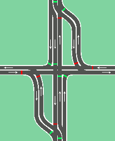
Part of the delay at a typical high-volume right-hand traffic intersection is to accommodate left-turns; through-traffic must wait for the traffic turning left because it crosses the path of the through traffic. The continuous flow intersection moves the left-turn conflict out of the intersection and synchronizes it with the signal cycle of the intersecting road.

In the adjacent diagram, while the left/right traffic flows through the main intersection, the left-turn traffic crosses to the opposite side of the oncoming traffic a few hundred feet away. Doing this removes the crossing conflict. When the north/south through traffic is allowed through the main intersection, the north/south left-turn lanes are also allowed through the intersections as their paths are no longer crossing. All traffic flow is controlled by traffic signals as at a regular intersection.

The Louisiana DOTD article on the Baton Rouge CFI includes a particularly informative diagram of that intersection. [12]

To reduce confusion regarding the left-turn lane, the left-turn lane and the straight-through lanes are usually separated by a concrete barrier or traffic island. This diagram shows the straight-through lanes offset by one lane through the intersection and are guided by lines painted through the intersection. But this is just a sample configuration; the lanes may be offset by more lanes or none at all.

Nonetheless, due to the provision of traffic between two directions of opposing traffic, some motorists tend to maintain an ongoing criticism of the intersection. Additionally, as in the case of the half-CFI in Accokeek, the offset left-turn traffic reenters the main traffic stream via a half-signal, requiring motorists to merge from a stop condition onto the higher-speed mainline. Motorists sometimes cite discomfort due to the speed differential, a known cause of accidents, though conflicts could be reduced through the provision of an adequate acceleration lane and merge area. The Accokeek, MD CFI also has notable inequalities in traffic flow depending upon the direction of travel.

This type of intersection can require a significant amount of right-of-way to implement (dependent upon the configuration), which is why the technique is not frequently used in urban areas. However, the amount of right-of-way necessary for construction and final operation is still typically less than that of an interchange. Additionally, as there is no grade separation involved, costs are considerably less than that of an interchange alternative.

Case studies

The redesign of the Redwood Road/6200 South intersection in Taylorsville, Utah cut emissions of carbon dioxide by 19 tons (17  tonnes) per year. [36] Compared to the previous design, the redesign of the Bangerter Highway/3500 South intersection saves 3+12 minutes of travel time per vehicle and 800,000 U.S. gallons (3,000,000 liters) of fuel per year, and has 60% fewer accidents nearby; it also cost $20 million to $40 million less in construction costs than a grade-separated alternative. [37]

Parallel-flow intersection

A parallel-flow intersection (PFI) is a variant similar to the CFI, patented in 2006. [38] It arranges the left-turning traffic in a different manner; it is not displaced, instead turning left closer to the intersection onto a parallel roadway, to the left of oncoming traffic. [39] This was first used in New Jersey at the junction of New Jersey Route 168 and US Highway 130, between Haddon Township and Camden ( 39°54′15″N75°05′45″W / 39.90412°N 75.095812°W / 39.90412; -75.095812 ).

See also

Related Research Articles

<span class="mw-page-title-main">Intersection (road)</span> Road junction where two or more roads either meet or cross at grade

An intersection or an at-grade junction is a junction where two or more roads converge, diverge, meet or cross at the same height, as opposed to an interchange, which uses bridges or tunnels to separate different roads. Major intersections are often delineated by gores and may be classified by road segments, traffic controls and lane design.

<span class="mw-page-title-main">Michigan left</span> Type of intersection

A Michigan left or P-turn is an at-grade intersection design that replaces each left (farside) turn at an intersection between a (major) divided roadway and a secondary (minor) roadway with the combination of a right (nearside) turn followed by a U-turn, or a U-turn followed by a right (nearside) turn, depending on the situation. It is in use in numerous countries.

<span class="mw-page-title-main">Cloverleaf interchange</span> A type of interchange using loop ramps

A cloverleaf interchange is a two-level interchange in which all turns are handled by slip roads. To go left, vehicles first continue as one road passes over or under the other, then exit right onto a one-way three-fourths loop ramp (270°) and merge onto the intersecting road. The objective of a cloverleaf is to allow two highways to cross without the need for any traffic to be stopped by traffic lights. The limiting factor in the capacity of a cloverleaf interchange is traffic weaving.

<span class="mw-page-title-main">Diamond interchange</span> Common type of road junction

A diamond interchange is a common type of road junction, used where a controlled-access highway crosses a minor road.

<span class="mw-page-title-main">Single-point urban interchange</span> Highway interchange design

A single-point urban interchange, also called a single-point interchange (SPI) or single-point diamond interchange (SPDI), is a type of highway interchange. The design was created in order to help move large volumes of traffic through limited amounts of space safely and efficiently.

<span class="mw-page-title-main">Partial cloverleaf interchange</span> Modification of a cloverleaf interchange

A partial cloverleaf interchange or parclo is a modification of a cloverleaf interchange.

<span class="mw-page-title-main">Jughandle</span> Diversionary road used for making turns at an intersection

A jughandle is a type of ramp or slip road that changes the way traffic turns left at an at-grade intersection. Instead of a standard left turn being made from the left lane, left-turning traffic uses a ramp on the right side of the road. In a standard forward jughandle or near-side jughandle, the ramp leaves before the intersection, and left-turning traffic turns left off of it rather than the through road; right turns are also made using the jughandle. In a reverse jughandle or far-side jughandle, the ramp leaves after the intersection, and left-turning traffic loops around to the right and merges with the crossroad before the intersection.

<span class="mw-page-title-main">Superstreet</span> Type of high capacity intersection

A superstreet, also known as a restricted crossing U-turn (RCUT), J-turn, or reduced conflict intersection (RCI), is a type of road intersection that is a variation of the Michigan left. In this configuration, in contrast to the Michigan left, traffic on the minor road is not permitted to proceed straight across the major road or highway. Drivers on the minor road wishing to turn left or go straight must turn right onto the major road, then, a short distance away, queue (wait) into a designated U-turn lane in the median. When traffic clears, they complete the U-turn and then either go straight or make a right turn when they intersect the other half of the minor road.

<span class="mw-page-title-main">Utah State Route 201</span> Highway in Utah

State Route 201 (SR-201) is an east–west expressway and freeway located in Salt Lake County in the U.S. state of Utah. Colloquially known by some as the 21st South Freeway, the route serves as an alternative to Interstate 80 (I-80) through Salt Lake City. From the western terminus of the route west of Magna, the highway heads east through Kennecott Copper property as an expressway before running through the western suburbs of Salt Lake City as a freeway. Shortly after the route returns on a surface route, SR-201 terminates on its eastern end at State Street.

<span class="mw-page-title-main">Utah State Route 154</span> State highway in Salt Lake County, Utah, United States

State Route 154 (SR-154) or Bangerter Highway is a partial expressway running west and then north from Draper through western Salt Lake County, eventually reaching the Salt Lake City International Airport in Salt Lake City. Construction began in 1988 after planning for the highway began more than two decades prior. For the next ten years, portions of the highway opened as constructed, with the entire route finished by 1998.

<span class="mw-page-title-main">Diverging diamond interchange</span> Freeway interchange design

A diverging diamond interchange (DDI), also called a double crossover diamond interchange (DCD), is a subset of diamond interchange in which the opposing directions of travel on the non-freeway road cross each other on either side of the interchange so that traffic crossing the freeway on the overpass or underpass is operating on the opposite driving side from that which is customary for the jurisdiction. The crossovers may employ one-side overpasses or be at-grade and controlled by traffic light.

<span class="mw-page-title-main">Mountain View Corridor</span> State highway in Utah and Salt Lake counties in Utah, United States

The Mountain View Corridor is a freeway under construction in northern Utah that will run along the western periphery of Salt Lake County and south into northwest Utah County. Except for the last several miles on its southern end the Mountain View Corridor is numerically designated as State Route 85 (SR-85) in the Utah state highway system. The entire Mountain View Corridor will be maintained by the Utah Department of Transportation (UDOT).

<span class="mw-page-title-main">Texas State Highway Loop 1604</span> Loop highway around San Antonio, Texas

Loop 1604 is the outer highway loop encircling San Antonio, Texas, spanning approximately 95.6 miles (153.9 km). Originally constructed as a two-lane highway, the northern segment of the route, from US 90 in western San Antonio to Kitty Hawk Road in northeastern Bexar County, has been upgraded to a four-lane freeway. Loop 1604 is designated the Charles W. Anderson Loop in honor of former Bexar County Judge Charles W. Anderson, who died from cancer in 1964 after serving for 25 years.

<span class="mw-page-title-main">Florida State Road 82</span> Highway in Florida

State Road 82 is a 29-mile-long east–west highway serving northern Lee and Collier County, Florida. The western terminus is an intersection with Cleveland Avenue in Fort Myers; the eastern terminus is an intersection with SR 29 midway between Immokalee and Felda.

<span class="mw-page-title-main">Ohio State Route 741</span> State highway in southwestern Ohio, US

State Route 741 is a north–south state highway in the southwest portion of the U.S. state of Ohio. The southern terminus of the route is at a diamond interchange with I-71 at its Exit 25 near Kings Mills, adjacent to the Kings Island Amusement Park. State Route 741’s northern terminus is at a partial interchange with I-75 at its Exit 50B in Moraine, just south of Dayton.

<span class="mw-page-title-main">Interstate 15 in Utah</span> Section of Interstate highway in Utah, United States

Interstate 15 (I-15) runs north–south in the U.S. state of Utah through the southwestern and central portions of the state, passing through most of the state's population centers, including St. George and those comprising the Wasatch Front: Provo–Orem, Salt Lake City, and Ogden–Clearfield. It is Utah's primary and only north–south interstate highway, as the vast majority of the state's population lives along its corridor; the Logan metropolitan area is the state's only Metropolitan Statistical Area through which I-15 does not pass. In 1998, the Utah State Legislature designated Utah's entire portion of the road as the Veterans Memorial Highway.

<span class="mw-page-title-main">Utah State Route 173</span> State highway in Salt Lake County, Utah, U.S.

State Route 173 is a major east–west thoroughfare completely within Salt Lake County in northern Utah. From its western terminus at SR-111 it passes through the growing west side of Salt Lake County, eventually reaching US-89 in Murray.

<span class="mw-page-title-main">Business routes of Interstate 40</span> Highway system

Interstate business routes are roads connecting a central or commercial district of a city or town with an Interstate bypass. These roads typically follow along local streets often along a former U.S. Route or state highway that had been replaced by an Interstate. Interstate business route reassurance markers are signed as either loops or spurs using a green shield shaped and numbered like the shield of the parent Interstate highway.

<span class="mw-page-title-main">Glossary of road transport terms</span>

Terminology related to road transport—the transport of passengers or goods on paved routes between places—is diverse, with variation between dialects of English. There may also be regional differences within a single country, and some terms differ based on the side of the road traffic drives on. This glossary is an alphabetical listing of road transport terms.

<span class="mw-page-title-main">Split intersection</span> Type of road intersection

A split intersection is a rarely built at-grade variant of the diamond interchange. Compared to a conventional four-leg intersection or road crossing, the arterial road is split into separate carriageways by 200 to 300 feet, allowing a queue of left turning vehicles behind a completed turn into the crossroad without any conflict to oncoming traffic. On the crossroad, the four leg intersection is being replaced by two intersections. The beginning one-way traffic at the fourth leg makes the intersections reduce the number of conflicts similar to a three leg T-intersection to improve traffic flow.

References

  1. Schroeder, Bastian; Cunningham, Chris; Ray, Brian; Daleiden, Andy; Jenior, Pete; Knudsen, Julia (August 2014). Diverging Diamond Interchange Informational Guide (PDF). Washington, DC: Federal Highway Administration Office of Safety.
  2. Hummer, Joseph E.; Reid, Jonathan D. "Unconventional Left-Turn Alternatives for Urban and Suburban Arterials" (PDF). Transportation Research Board. Archived from the original (PDF) on 30 September 2007. Retrieved 13 June 2007.
  3. United States Patent and Trademark Office, US 5049000
  4. Telegraph Road, Michigan 42°22′17″N83°16′32″W / 42.371267°N 83.275563°W
  5. "Australia's first 'Continuous Flow Intersection' is now open on the GC!". 13 December 2017.
  6. "Radical plan to ease Hoddle Street gridlock". 21 March 2015.
  7. "Community Update - June 2017 - Alexandria to Moore Park Connectivity Upgrade" (PDF). NSW Government - Roads & Maritime Services.
  8. "Displaced Left Turn Intersection". Prince Edwards Island. 3 November 2020.
  9. Areal photos in Google Earth of 31 December 2002, retrieved 22. July 2015
  10. 1 2 Bruce, Michael G.; Gruner, Paul W. (2005-12-28). "Continuous flow intersections". CENews.com. Retrieved 13 June 2007.
  11. Xianfeng Yang and Yang Lu Gang-Len Chang: An Integrated Computer System for Analysis Selection and Evaluation of Unconventional Intersections Report, University Of Maryland and Maryland State Highway Administration, Publication No. MD-11-SP909B4H, March 2011, retrieved 25 March 2015
  12. 1 2 Ruiz de Chavez, Lindsay (2006-03-21). "First 'continuous-flow' intersection in the state opens on Airline today". Louisiana Department of Transportation & Development. Archived from the original on 2010-05-27. Retrieved 4 August 2018.
  13. "3500 South & Bangerter Highway CFI (Continuous Flow Intersection)". Utah Department of Transportation. Archived from the original on 18 June 2007. Retrieved 13 June 2007.
  14. Johnson, Whit. "Continuous Flow Intersection Opens to Rush Hour Traffic". KSL Newsradio. Retrieved 17 September 2007.
  15. Crouch, Elisa. "How do you get through this?". St. Louis Post-Dispatch. Retrieved 31 October 2007.[ permanent dead link ]
  16. "Continuous Flow Intersections". Missouri Department of Transportation - St. Louis Area District. Archived from the original on 27 September 2007. Retrieved 13 June 2007.
  17. "Austin Pike Interchange ODOT". Ohio Department of Transportation-District 7. Archived from the original on 2009-01-02. Retrieved 2009-02-26.
  18. Boal, Jed. "UDOT plans Flex Lanes to ease congestion on 5400 South". KSL Newsradio. Retrieved 13 October 2009.
  19. "Officials break ground on Camillia/Johnston project". The Advertiser. Retrieved 27 January 2010.[ dead link ]
  20. "Madison Improvements at US Hwy 34". City of Loveland. Archived from the original on 12 September 2010. Retrieved 12 October 2010.
  21. "University Parkway CFI". Archived from the original on 2011-10-29.
  22. US 160/US 550 Durango Continuous Flow Intersection
  23. "Final section of ICC to Laurel, new I-95 interchange to open this weekend". The Baltimore Sun. November 5, 2014. Retrieved November 9, 2014.
  24. "Continuous Flow Intersection". 7 August 2017.
  25. "OPD responds to crash at key intersection". 25 August 2015.
  26. "Innovative intersection now open Continuous Flow Intersection (CFI) at RM 1431 and Ronald Reagan Boulevard/ Parmer Lane now open. Follow the signs, stay in the lines". City of Cedar Park News. November 16, 2016. Retrieved December 2, 2020.
  27. Intersection Improvements to SH 80 and Loop 82 at I-35 Archived 2015-11-19 at the Wayback Machine , Texas State University, retrieved December 30, 2014
  28. "Continuous flow intersection now open in Dawson".
  29. "Continuous Flow Intersection". Anderson Township, Hamilton County, Ohio. January 2018. Retrieved March 18, 2018.
  30. Kraemer, Ally (May 8, 2017). "New continuous flow intersection opening May 19 at Beechmont, Five Mile in Anderson Township". WCPO-TV . E. W. Scripps Company. Retrieved March 18, 2018.
  31. "Woodmen Road Corridor CFI Intersection (long version)". City of Colorado Springs. November 29, 2017. Retrieved January 3, 2018.
  32. "Virginia's First Continuous Flow Intersection Now Open to Traffic on Military Highway". Virginia Department of Transportation. July 30, 2018. Retrieved March 14, 2019.
  33. "It's Here: SA's First DLT Intersection Opens This Weekend". Texas Department of Transportation - Go Ahead!. Retrieved 1 May 2019.
  34. Dickert, Allyssa (9 July 2019). "New Continuous Flow Intersection now open in Lehigh Acres". Fox 4 Now. Retrieved 9 July 2019.
  35. Vickers, Nathan (19 May 2021). "New Olathe intersection is first of its kind in Kansas". KCTV 5. Retrieved 16 February 2022.
  36. FHWA: DLT Case Study – Redwood Road at 6200 South in Taylorsville (Utah), published July 31, 2014
  37. FHWA: DLT Case Study – Bangerter Highway in Salt Lake County (Utah), published July 31, 2014
  38. B2 USpatent 7135989 B2,Gregory Fife Parsons,"Parallel flow vehicle turn system for traffic intersections",issued 2006-11-14, assigned to Gregory Fife Parsons
  39. Federal Highway Administration: Alternative Intersections/Interchanges: Informational Report (AIIR), Publication Number: FHWA-HRT-09-060, April 2010