
A highway is any public or private road or other public way on land. It includes not just major roads, but also other public roads and rights of way. In the United States, it is also used as an equivalent term to controlled-access highway, or a translation for motorway, Autobahn, autostrada, autoroute, etc.

Traffic engineering is a branch of civil engineering that uses engineering techniques to achieve the safe and efficient movement of people and goods on roadways. It focuses mainly on research for safe and efficient traffic flow, such as road geometry, sidewalks and crosswalks, cycling infrastructure, traffic signs, road surface markings and traffic lights. Traffic engineering deals with the functional part of transportation system, except the infrastructures provided.

Highway engineering is a professional engineering discipline branching from the civil engineering subdiscipline of transportation engineering that involves the planning, design, construction, operation, and maintenance of roads, highways, streets, bridges, and tunnels to ensure safe and effective transportation of people and goods. Highway engineering became prominent towards the latter half of the 20th century after World War II. Standards of highway engineering are continuously being improved. Highway engineers must take into account future traffic flows, design of highway intersections/interchanges, geometric alignment and design, highway pavement materials and design, structural design of pavement thickness, and pavement maintenance.
Level of service (LOS) is a qualitative measure used to relate the quality of motor vehicle traffic service. LOS is used to analyze roadways and intersections by categorizing traffic flow and assigning quality levels of traffic based on performance measure like vehicle speed, density, congestion, etc. In a more general sense, levels of service can apply to all services in asset management domain.

A dual carriageway (BrE) or a divided highway (AmE) is a class of highway with carriageways for traffic travelling in opposite directions separated by a central reservation (BrE) or median (AmE). Roads with two or more carriageways which are designed to higher standards with controlled access are generally classed as motorways, freeways, etc., rather than dual carriageways.

In civil engineering, grade separation is a method of aligning a junction of two or more surface transport axes at different heights (grades) so that they will not disrupt the traffic flow on other transit routes when they cross each other. The composition of such transport axes does not have to be uniform; it can consist of a mixture of roads, footpaths, railways, canals, or airport runways. Bridges, tunnels, or a combination of both can be built at a junction to achieve the needed grade separation.

The road hierarchy categorizes roads according to their functions and capacities. While sources differ on the exact nomenclature, the basic hierarchy comprises freeways, arterials, collectors, and local roads. Generally, the functional hierarchy can more or less correspond to the hierarchy of roads by their owner or administrator.

An elevated highway is a controlled-access highway that is raised above grade for its entire length. Elevation is usually constructed as viaducts, typically a long pier bridge. Technically, the entire highway is a single bridge.

The street hierarchy is an urban planning technique for laying out road networks that exclude automobile through-traffic from developed areas. It is conceived as a hierarchy of roads that embeds the link importance of each road type in the network topology. Street hierarchy restricts or eliminates direct connections between certain types of links, for example residential streets and arterial roads, and allows connections between similar order streets or between street types that are separated by one level in the hierarchy. By contrast, in many regular, traditional grid plans, as laid out, higher order roads are connected by through streets of both lower order levels. An ordering of roads and their classification can include several levels and finer distinctions as, for example, major and minor arterials or collectors.

A collector road or distributor road is a low-to-moderate-capacity road which serves to move traffic from local streets to arterial roads. Unlike arterials, collector roads are designed to provide access to residential properties. Rarely, jurisdictions differentiate major and minor collector roads, the former being generally wider and busier.

A junction is where two or more roads meet.

Roadway air dispersion modeling is the study of air pollutant transport from a roadway or other linear emitter. Computer models are required to conduct this analysis, because of the complex variables involved, including vehicle emissions, vehicle speed, meteorology, and terrain geometry. Line source dispersion has been studied since at least the 1960s, when the regulatory framework in the United States began requiring quantitative analysis of the air pollution consequences of major roadway and airport projects. By the early 1970s this subset of atmospheric dispersion models was being applied to real-world cases of highway planning, even including some controversial court cases.

Roadway noise is the collective sound energy emanating from motor vehicles. It consists chiefly of road surface, tire, engine/transmission, aerodynamic, and braking elements. Noise of rolling tires driving on pavement is found to be the biggest contributor of highway noise and increases with higher vehicle speeds.
The city of Calgary, Alberta, has a large transportation network that encompasses a variety of road, rail, air, public transit, and pedestrian infrastructure. Calgary is also a major Canadian transportation centre and a central cargo hub for freight in and out of north-western North America. The city sits at the junction between the "Canamex" highway system and the Trans-Canada Highway.
Gilberts Corner is an unincorporated area at the intersection of U.S. Route 50 and U.S. Route 15 in Loudoun County, Virginia, located east of the historic village of Aldie.

A line source, as opposed to a point source, area source, or volume source, is a source of air, noise, water contamination or electromagnetic radiation that emanates from a linear (one-dimensional) geometry. The most prominent linear sources are roadway air pollution, aircraft air emissions, roadway noise, certain types of water pollution sources that emanate over a range of river extent rather than from a discrete point, elongated light tubes, certain dose models in medical physics and electromagnetic antennas. While point sources of pollution were studied since the late nineteenth century, linear sources did not receive much attention from scientists until the late 1960s, when environmental regulations for highways and airports began to emerge. At the same time, computers with the processing power to accommodate the data processing needs of the computer models required to tackle these one-dimensional sources became more available.

The normal function of traffic lights requires more than sight control and coordination to ensure that traffic and pedestrians move as smoothly, and safely as possible. A variety of different control systems are used to accomplish this, ranging from simple clockwork mechanisms to sophisticated computerized control and coordination systems that self-adjust to minimize delay to people using the junction.
Urban freight distribution is the system and process by which goods are collected, transported, and distributed within urban environments. The urban freight system can include seaports, airports, manufacturing facilities, and warehouse/distribution centers that are connected by a network of railroads, rail yards, pipelines, highways, and roadways that enable goods to get to their destinations.

A managed lane is a type of highway lane that is operated with a management scheme, such as lane use restrictions or variable tolling, to optimize traffic flow, vehicle throughput, or both. Definitions and goals vary among transport agencies, but managed lanes are generally implemented to achieve an improved operational condition on a highway, such as improving traffic speed and throughput, reducing air pollution, and improving safety. Types of managed lanes include high-occupancy vehicle (HOV) lanes, high-occupancy toll lanes, express toll lanes, reversible lanes, and bus lanes. Most managed lane facilities are located in the United States and Canada, although HOV and bus lanes can be found in many other countries; outside of the US and Canada, many countries use active traffic management that manage all lanes of a highway.
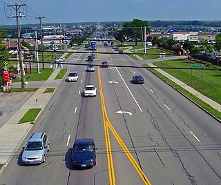
A stroad is a type of street–road hybrid. Common in the United States and Canada, stroads are wide arterials that often provide access to strip malls, drive-throughs, and other automobile-oriented businesses. Stroads have been criticized by urban planners for their safety issues and inefficiencies. While streets serve as a destination and provide access to shops and residences at safe traffic speeds, and roads serve as a high-speed connection that can efficiently move traffic at high speed and volume, stroads are often expensive, inefficient, and dangerous.
