
The Trans-Canada Highway is a transcontinental federal–provincial highway system that travels through all ten provinces of Canada, from the Pacific Ocean on the west coast to the Atlantic Ocean on the east coast. The main route spans 7,476 km (4,645 mi) across the country, one of the longest routes of its type in the world. The highway system is recognizable by its distinctive white-on-green maple leaf route markers, although there are small variations in the markers in some provinces.

A shoulder, hard shoulder or breakdown lane is an emergency stopping lane by the verge on the outer side of a road or motorway. Many wider freeways, or expressways elsewhere have shoulders on both sides of each directional carriageway—in the median, as well as at the outer edges of the road, for additional safety. Shoulders are not intended for use by through traffic, although there are exceptions.

The N4 road is a national primary road in Ireland, running from Dublin to the northwest of Ireland and Sligo town. The M6 to Galway diverges from this route after Kinnegad, while the N5 to Westport diverges at Longford town. Most sections of the N4 that are motorway-standard are designated the M4 motorway.

A dual carriageway (BrE) or a divided highway (AmE) is a class of highway with carriageways for traffic travelling in opposite directions separated by a central reservation (BrE) or median (AmE). Roads with two or more carriageways which are designed to higher standards with controlled access are generally classed as motorways, freeways, etc., rather than dual carriageways.
King's Highway 17, more commonly known as Highway 17, is a provincially maintained highway and the primary route of the Trans-Canada Highway through the Canadian province of Ontario. It begins at the Manitoba boundary, 50 km (31 mi) west of Kenora, and the main section ends where Highway 417 begins just west of Arnprior. A small disconnected signed section of the highway still remains within the Ottawa Region between County Road 29 and Grants Side Road. This makes it Ontario's longest highway.
King's Highway 417, commonly referred to as Highway 417 and as the Queensway through Ottawa, is a 400-series highway in the Canadian province of Ontario. It connects Ottawa with Montreal via A-40, and is the backbone of the highway system in the National Capital Region. Within Ottawa, it forms part of the Queensway west from Highway 7 to Ottawa Road 174. Highway 417 extends from the Quebec border, near Hawkesbury, to Arnprior, where it continues westward as Highway 17. Aside from the urban section through Ottawa, Highway 417 passes through farmland that dominates much of the fertile Ottawa Valley.
King's Highway 400, commonly referred to as Highway 400, historically as the Toronto–Barrie Highway, and colloquially as the 400, is a 400-series highway in the Canadian province of Ontario linking the city of Toronto in the urban and agricultural south of the province with the scenic and sparsely populated central and northern regions. The portion of the highway between Toronto and Lake Simcoe roughly traces the route of the Toronto Carrying-Place Trail, a historic trail between the Lower and Upper Great Lakes. North of Highway 12, in combination with Highway 69, it forms a branch of the Trans-Canada Highway (TCH), the Georgian Bay Route, and is part of the highest-capacity route from southern Ontario to the Canadian West, via a connection with the mainline of the TCH in Sudbury. The highway also serves as the primary route from Toronto to southern Georgian Bay and Muskoka, areas collectively known as cottage country. The highway is patrolled by the Ontario Provincial Police and has a speed limit of 100 km/h (62 mph), except for the section south of Highway 401, where the speed limit is 80 km/h (50 mph) and the 60 km (37 mi) stretch between MacTier and Nobel, where the speed limit was raised to 110 km/h (68 mph) on April 22, 2022.

The road hierarchy categorizes roads according to their functions and capacities. While sources differ on the exact nomenclature, the basic hierarchy comprises freeways, arterials, collectors, and local roads. Generally, the functional hierarchy can more or less correspond to the hierarchy of roads by their owner or administrator.

A limited-access road, known by various terms worldwide, including limited-access highway, dual-carriageway, expressway, and partial controlled-access highway, is a highway or arterial road for high-speed traffic which has many or most characteristics of a controlled-access highway, including limited or no access to adjacent property, some degree of separation of opposing traffic flow, use of grade separated interchanges to some extent, prohibition of slow modes of transport, such as bicycles, horse-drawn vehicles or ridden horses, or self-propelled agricultural machines; and very few or no intersecting cross-streets or level crossings. The degree of isolation from local traffic allowed varies between countries and regions. The precise definition of these terms varies by jurisdiction.
Autoroute 20 is a Quebec Autoroute, following the Saint Lawrence River through one of the more densely populated parts of Canada, with its central section forming the main route of the Trans-Canada Highway from the A-25 interchange to the A-85 interchange. At 585 km (363.5 mi), it is the longest Autoroute in Quebec. It is one of two main links between Montreal and Quebec City; the other is the A-40.
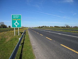
The N52 road is a national secondary road in Ireland. It links the M7 motorway from just south of Nenagh, County Tipperary to the M1 motorway north of Dundalk in County Louth. The route forms a connection between the north east of Ireland and the mid west traversing the midlands. It interchanges with the M6 at Kilbeggan and at Tyrrellspass, the N4 at Mullingar, the N3 at Kells, and the N2 at Ardee before continuing towards Dundalk.

A controlled-access highway is a type of highway that has been designed for high-speed vehicular traffic, with all traffic flow—ingress and egress—regulated. Common English terms are freeway, motorway, and expressway. Other similar terms include throughway or thruway and parkway. Some of these may be limited-access highways, although this term can also refer to a class of highways with somewhat less isolation from other traffic.
Autoroute 30 (A-30), or the Autoroute de l'Acier is an Autoroute in Quebec, Canada. Construction of the A-30 dates back to the early days of autoroute construction in the 1960s. Originally called Highway 3, the A-30 was designed to replace Route 132 as the main artery linking the communities along the South Shore of the St. Lawrence River. The A-30 was originally intended to begin at the U.S. border near Dundee and end at Saint-Pierre-les-Becquets. In the late 1970s an eight-year moratorium on new autoroute construction in favour of public transport by the Parti Québécois prevented implementation of that plan.

2+1 road is a specific category of three-lane road, consisting of two lanes in one direction and one lane in the other, alternating every few kilometres, and usually separated with a steel cable barrier. The second lane allows faster-moving traffic to overtake slower vehicles at regular intervals. Traditional roads of at least 10 metres (33 ft) width can be converted to 2+1 roads and reach near-motorway safety levels at a much lower cost than an actual conversion to motorway or dual carriageway.
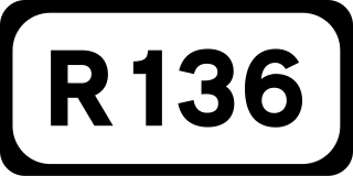
The R136 road is a regional road in Ireland, located in the southwest of Dublin. Named the Outer Ring Road, the route, which is dual carriageway, runs from the N4 at Lucan to the N81 at Tallaght, bypassing west of Clondalkin and crossing the N7 near Citywest. It was built as part of the planning for the new town of Adamstown.
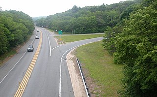
A two-lane expressway or two-lane freeway is an expressway or freeway with only one lane in each direction, and usually no median barrier. It may be built that way because of constraints, or may be intended for expansion once traffic volumes rise. The term super two is often used by roadgeeks for this type of road, but traffic engineers use that term for a high-quality surface road. Most of these roads are not tolled.
The Dunedin Southern Motorway is the main arterial route south from the South Island city of Dunedin, part of New Zealand's State Highway 1. Despite its name, only a portion of the route is officially classified as motorway. The route is the southernmost section of median-divided highway in the world.

In Ireland, the highest category of road is a motorway, indicated by the prefix M followed by a one- or two-digit number. The motorway network consists entirely of motorway-grade dual carriageways and is largely focused upon Dublin. There are also several three-lane motorways, while Ireland's busiest road, the M50, incorporates four-lane, five-lane, and six-lane stretches.
This article describes the highway systems available in selected countries.
Twinning a road involves the construction of a similar or identical parallel road. It is usually done when an existing highway requires a significant increase in capacity. Twinning is frequently advantageous because it allows traffic capacity to be doubled and produces a dual carriageway with separation between traffic directions and keeps the existing right of way. Additionally, unlike simple widening, twinning has minimal construction impact for traffic on the old road while the twin is being built.