Quebec Autoroute 50

Last updated

Quebec Autoroute 50.svg

Autoroute 50

Autoroute Guy-Lafleur
Quebec Autoroute 50
Route information
Maintained by Transports Québec
Length158.3 km [1] [2]  (98.4 mi)
Existed1975 [1] –present
Major junctions
West endRue Montcalm in Gatineau
Major intersections
East endQc117.svg R-117 in Mirabel
Location
Country Canada
Province Quebec
Major cities Gatineau, Mirabel, Lachute, Brownsburg-Chatham, L'Ange-Gardien
Highway system
Quebec Autoroute 40.svg A-40 Quebec Autoroute 55.svg A-55
Autoroute 50 between Fassett and Calumet in the Ottawa River Valley Highway 50 QC.JPG
Autoroute 50 between Fassett and Calumet in the Ottawa River Valley

Autoroute 50 (Autoroute Guy-Lafleur) is an Autoroute in western Quebec, Canada. It links Canada's National Capital Region (Gatineau) and the Greater Montreal area (Mirabel).

Contents

Until November 2012, there were two distinct sections of A-50: one section running eastward from Hull and the other westward from Mirabel. The gap in the highway was filled on November 26, 2012, and the two-lane freeway opened for traffic on the full 159 km (98.8 mi) length. [3] [4]

The route provides an east-west freeway alternative to Route 148 that does not require travelling in Ontario, unlike the main Trans-Canada Highway route (A-40 / Hwy 417).

Originally named Autoroute de l'Outaouais, it was announced on April 28, 2023, that A-50 would be renamed to Autoroute Guy-Lafleur in honor of the former Montreal Canadiens player who died of lung cancer a year earlier. [5] The Quebec government officially announced the name change on May 4 in Thurso, Lafleur's birthplace. [6]

History

Oswald Parent (a Liberal MP from Hull) originally proposed construction of the A-50 in 1962. Eight years later, Quebec Premier Jean-Jacques Bertrand announced plans for construction. It was originally envisioned that the A-50 would extend over 400 km from L'Isle-aux-Allumettes at the Ontario border through Saint-Jérôme and Joliette along the Route 148 and 158 corridors to Berthierville and a junction with the A-40. The primary purpose of the A-50 was to connect Ottawa and the Outaouais with Montréal–Mirabel International Airport.

At the time, the Ottawa Macdonald–Cartier International Airport was not yet built, and the national capital lacked highway access to an international air hub. Mirabel's rapid decline as an air hub as well as the Quebec government's decision in the 1970s to impose a moratorium on new autoroute construction resulted in a significantly truncated route for the A-50. Plans for extending the A-50 west of Hull and east of the A-15/TCH were abandoned. The exit numbers, however, are based on that original projected length of the autoroute.

Construction was completed in the fall of 2007 on the road that connects Highway 148 west of the Aylmer and Hull sectors to the A-50 at the Boulevard des Allumettières interchange.

One short section of Route 158 around Joliette was originally signed as A-50 as well until the project was abandoned. In addition, west of the current terminus, a four-lane at-grade expressway continues as Route 148 into the Aylmer section of Gatineau; it may become part of A-50 in the future.

A-50 is a four- to six-lane freeway through Gatineau up to Buckingham, the remainder is mostly a two-lane freeway. Many overpasses are built to accommodate a fully divided, four-lane highway in the future such that only one portion of the overpass is currently used. However, there have been demands for a four-lane highway for the new segment so it can be safer. The first two segments were built with only two lanes and a 2007 multi-fatality accident occurred on highway 148 near Buckingham, a section of highway that A-50 would bypass. [7]

Unusual for a limited-access highway, the A-50 contains two railway crossings at grade, both of the Quebec Gatineau Railway (QGRY). The first crosses the QGRY Lachute Subdivision between exits 260 and 272, at 45°39′04″N74°13′45″W / 45.651008°N 74.229047°W / 45.651008; -74.229047 , while the second crosses the QGRY St-Jerome Spur about 1 km west of exit 279, at 45°40′59″N74°07′34″W / 45.682948°N 74.125982°W / 45.682948; -74.125982 .

There has been some support to rename the highway Autoroute Maurice-Richard after historic Montreal Canadiens hockey player Maurice Richard, but the Commission de toponymie du Québec chose to wait until the section between Buckingham and Notre-Dame-de-Bonsecours was finished before making a decision, and to date no renaming has happened. [8]

In 2022, following the death of Montreal Canadiens hockey legend Guy Lafleur (who was a native of Thurso), the Quebec government openly considered renaming the highway after Lafleur following a request made by the Minister Responsible for the Outaouais Region Mathieu Lacombe and by Thurso mayor Benoit Lauzon. [9] [10] In late April 2023, Quebec newspaper Le Droit reported that the highway would officially be renamed Autoroute Guy-Lafleur in a ceremony happening in Thurso on Thursday, May 4, 2023, in which both Lacombe and Quebec premier François Legault would be in attendance for. [11] [12]

Safety improvements

Following a series of fatal collisions in 2007, it was announced that centreline rumble strips would be installed in various no-passing zones along Autoroute 50. This is the first installation of its kind in Quebec and serves as a pilot project.

The two at-grade intersections at km 281 and 283 were removed in 2016.

Exit list

RCMLocationkm [2] miExitDestinationsNotes
Gatineau 0.00.0Rue MontcalmAt-grade intersection; western terminus
0.30.19134Qc148.svg R-148 west (Boulevard des Allumettières)Westbound exit and eastbound entrance; signed as exits 134-O (west) and 134-E (east); west end of R-148 concurrency
1.3–
2.3
0.81–
1.4
135Quebec Autoroute 5.svg A-5 (Autoroute de la Gatineau) Gatineau Centre-Ville, Ottawa, Maniwaki A-5 exit 2
3.52.2138Qc307.svg R-307 (Rue Saint-Louis) Cantley
4.72.9139Qc148.svg R-148 east (Boulevard Maloney)Eastbound exit and westbound entrance; east end of R-148 concurrency
4.83.0140Boulevard de La GappeWestbound access to R-148 east
6.84.2141Boulevard de La VérendryeEastbound exit and westbound entrance
11.16.9145Montée Paiement
13.78.5147Boulevard Labrosse
16.410.2150Qc366.svg R-366 (Boulevard Lorrain)
20.112.5154Quebec I-300-1.svg Boulevard de l'Aéroport Gatineau-Ottawa Executive Airport
25.716.0159Avenue des Laurentides
31.119.3165Rue GeorgesEastbound exit and westbound entrance
31.919.8166Qc315.svgQc148.svg R-315 (Chemin de Masson / Avenue de Buckingham) to R-148 Transition from 4 to 2 lanes or vice versa
36.422.6171Chemin Lépine
Les Collines-de-l'Outaouais L'Ange-Gardien 39.824.7174Qc309.svg R-309 north / Chemin Doherty Mont-Laurier
Papineau Thurso 52.532.6187Qc317.svg R-317  Thurso, Ripon
Plaisance 62.839.0197Montée Papineau
Papineauville 70.343.7205Qc321.svg R-321  Papineauville, Saint-André-Avellin Transition from 2 to 4 lanes or vice versa
Notre-Dame-de-Bonsecours 76.247.3210Qc323.svg R-323  Montebello, Mont-Tremblant Transition from 4 to 2 lanes or vice versa
Fassett 82.751.4216 Fassett
Argenteuil Grenville-sur-la-Rouge 92.357.4226Chemin Avoca Grenville-sur-la-Rouge, Harrington
99.661.9233Chemin Kilmar
105.765.7239Qc344.svgQc148.svg R-344 south to R-148  / Chemin Scotch  Grenville, Hawkesbury To Ontario Highway 34
Brownsburg-Chatham 118.273.4252Montée Labranche
120.374.8254Qc148.svg R-148 (Rue Principale) Lachute Transition from 2 to 4 lanes or vice versa
Lachute 124.277.2258Qc327.svgOntario M508.svg R-327 (Avenue d'Argenteuil) Saint-André-d'Argenteuil To CarillonPointe-Fortune ferry
126.378.5260Qc329.svg R-329 (Chemin Béthanie) Lachute Centre-Ville, Mirabel (Saint-Hermas)Transition from 4 to 2 lanes or vice versa
Mirabel 138.686.1272Qc148.svg R-148 (Route Arthur-Sauvé) to R-158  Saint-Eustache
145.290.2279 Saint-Colomban, Mirabel (Saint-Canut, Sainte-Scholastique)
150.293.3285Quebec I-300-1.svg Boulevard Henri-Fabre O. Mirabel International Airport Signed as exits 285-N (north) and 285-S (south) westbound; transition from 2 to 4 lanes or vice versa
152.894.9288Boulevard Henri-Fabre
156.2–
157.9
97.1–
98.1
292Quebec Autoroute 15.svgTrans-Canada Highway shield.svg A-15 (TCH) (Autoroute des Laurentides) Saint-Jérôme, Montréal Signed as exits 292-N (north) and 292-S (south); exit 35 on A-15
158.398.4Qc117.svg R-117 (Boulevard Curé-Labelle) Saint-Jérôme, Mirabel (Saint-Janvier)At-grade intersection; eastern terminus
1.000 mi = 1.609 km; 1.000 km = 0.621 mi

Related Research Articles

<span class="mw-page-title-main">National Capital Region (Canada)</span> Metropolitan area in Canada

The National Capital Region (NCR), also known as Canada's Capital Region and Ottawa–Gatineau, is an official federal designation encompassing the Canadian capital of Ottawa, Ontario, the adjacent city of Gatineau, Quebec, and surrounding suburban and exurban areas. Despite its designation, the NCR is not a separate political or administrative entity and falls within the provinces of Ontario and Quebec.

Autoroute 5 is a short controlled-access Autoroute in the Outaouais region of western Quebec. It connects the central urban area of Gatineau with the recreational areas of Gatineau Park and the exurban rural areas of Chelsea and La Pêche. The southern terminus provides access to the Macdonald-Cartier Bridge, which continues into downtown Ottawa. The A-5 generally has four lanes of traffic with the exception of southernmost section across the Macdonald-Cartier Bridge where A-5 widens to six lanes.

Autoroute 20 is a Quebec Autoroute, following the Saint Lawrence River through one of the more densely populated parts of Canada, with its central section forming the main route of the Trans-Canada Highway from the A-25 interchange to the A-85 interchange. At 585 km (363.5 mi), it is the longest Autoroute in Quebec. It is one of two main links between Montreal and Quebec City; the other is the A-40.

Autoroute 40, officially known as Autoroute Félix-Leclerc outside Montreal and Metropolitan Autoroute/Autoroute Métropolitaine within Montreal, is an Autoroute on the north shore of the St. Lawrence River in the Canadian province of Quebec. It is one of the two major connections between Montreal and Quebec City, the other being Autoroute 20 on the south shore of the St. Lawrence. Autoroute 40 is currently 347 km (215.6 mi) long. Between the Ontario–Quebec boundary and the interchange with Autoroute 25, the route is signed as part of the Trans-Canada Highway.

Autoroute 15 is a highway in western Quebec, Canada. It was, until the extension of Autoroute 25 was opened in 2011, the only constructed north-south autoroute to go out of Montreal on both sides. A-15 begins at the end of Interstate 87 at the United States border at Saint-Bernard-de-Lacolle and extends via Montreal to Sainte-Agathe-des-Monts with an eventual continuation beyond Mont-Tremblant. The total length of A-15 is currently 164 km (101.9 mi), including a short concurrency with Autoroute 40 that connects the two main sections. This is one of the few autoroutes in Quebec that does not have any spinoff highways.

Autoroute 73 is an autoroute in Quebec, Canada. Following a northwest-southeast axis perpendicular to the Saint Lawrence River, the A-73 provides an important freeway link with regions north and south of Quebec City, the capital of the province. It also intersects with Autoroute 20 and Autoroute 40 - one of only three Quebec autoroutes to do so. The A-73 begins less than 40 kilometres from the U.S. border in Quebec's Beauce region, traverses metropolitan Quebec City, and ends in the Laurentian Mountains. Civic, political, and business leaders in regions north and south of the A-73's termini have lobbied the Quebec government to extend the autoroute. While the four-laning of Route 175 to Saguenay has alleviated concerns in the north about safety and connectivity, Quebecers in the Beauce continue to advocate for extending the A-73 to the U.S. border, towards the Armstrong–Jackman Border Crossing and U.S. Route 201 within Maine.

<span class="mw-page-title-main">Mario Laframboise</span> Canadian politician

Mario Laframboise is a Canadian politician who served as Mayor of Notre-Dame-de-la-Paix and Reeve of the Papineau MRC before getting into federal politics. In the 2000 Canadian federal election, Laframboise was elected to the House of Commons of Canada as the Bloc Québécois candidate in the riding of Argenteuil—Papineau—Mirabel. He was easily re-elected in the 2004, 2006 and 2008 elections, however he was defeated in the 2011 election by NDP's Mylène Freeman. A former notary, he was the Bloc critic to the Minister of Transport and later to the Minister of Infrastructure. He was also vice-president of the federal permanent committee of Transport, Infrastructure and Communities.

<span class="mw-page-title-main">Thurso, Quebec</span> City in Quebec, Canada

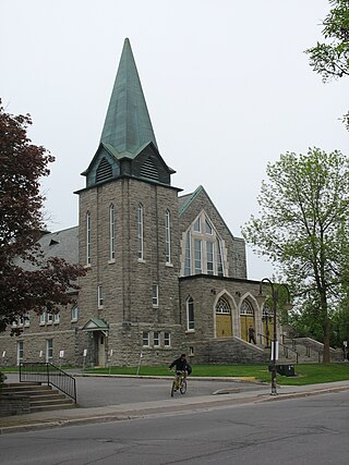
Thurso is a city in Papineau Regional County Municipality in the Outaouais region of western Quebec, Canada. It is located opposite Clarence, Ontario on the Ottawa River, and is within Canada's National Capital Region. Its population was 3,084 as of the 2021 Canadian Census.

Autoroute 30 (A-30), or the Autoroute de l'Acier is an Autoroute in Quebec, Canada. Construction of the A-30 dates back to the early days of autoroute construction in the 1960s. Originally called Highway 3, the A-30 was designed to replace Route 132 as the main artery linking the communities along the South Shore of the St. Lawrence River. The A-30 was originally intended to begin at the U.S. border near Dundee and end at Saint-Pierre-les-Becquets. In the late 1970s an eight-year moratorium on new autoroute construction in favour of public transport by the Parti Québécois prevented implementation of that plan.

<span class="mw-page-title-main">Quebec Autoroute 13</span> Highway in Quebec

Autoroute 13, is a freeway in the urban region of Montreal, Quebec, Canada. Its southern end is at the junction of A-20 on the Island of Montreal near Pierre Elliott Trudeau International Airport. Its northern terminus is at the junction of A-640 near Boisbriand. The road traverses Laval. A-13 is mostly six-laned and tolls were removed.

<span class="mw-page-title-main">Boulevard Saint-Joseph</span>

Boulevard Saint-Joseph is a commercial boulevard in the former city of Hull, Quebec. It runs from Boulevard Alexandre-Taché to the boundaries of the Gatineau and the suburban town of Chelsea.

<span class="mw-page-title-main">Rapibus</span> Bus transit system in Gatineau, Quebec

The Rapibus is a bus rapid transit system for the Société de Transport de l'Outaouais (STO) in the city of Gatineau, Quebec. Construction was completed in the summer of 2013 with service beginning in the fall. The Rapibus aims to speed up the service for commuters in growing sub-divisions in the northern and eastern areas of the city by alleviating the congestion on key arteries currently served by bus-designated lanes. A direct link to Ottawa is included.

<span class="mw-page-title-main">Quebec Autoroute 19</span> Highway in Quebec

Autoroute 19, also known as Autoroute Papineau, is an autoroute in Quebec. It crosses the Rivière des Prairies via the Papineau-Leblanc Bridge, connecting the borough of Ahuntsic-Cartierville in Montreal and the Duvernay neighbourhood in Laval.

<span class="mw-page-title-main">Quebec Route 148</span> Highway in Quebec

Route 148 is an east-west highway in Quebec, Canada. It runs from junction of Autoroute 13 and Autoroute 440 in Laval in the Montreal region to the Ontario-Quebec border in L'Isle-aux-Allumettes in western Quebec. For most of its length, Route 148 follows the north shore of the Ottawa River where it acted as the principal route between communities in the Outaouais region until the completion of Autoroute 50 in 2012. At the Ontario-Quebec border in L'Isle-aux-Allumettes Route 148 continues into Ontario as Highway 148.

<span class="mw-page-title-main">Quebec Route 117</span> Highway in Quebec

Route 117, the Trans Canada Highway Northern Route, is a provincial highway within the Canadian province of Quebec, running between Montreal and the Quebec/Ontario border where it continues as Highway 66 east of McGarry, Ontario. It is an important road since it is the only direct route between southern Quebec and the Abitibi-Témiscamingue region.

<span class="mw-page-title-main">Quebec Route 158</span> Highway in Quebec

Route 158 is an east-west arterial road running between Lachute and Berthierville, north of the Ottawa and Saint Lawrence rivers, in the Laurentides region.

Autoroute 85 is a Quebec Autoroute and the route of the Trans-Canada Highway in the province's Bas-Saint-Laurent region, also known as Autoroute Claude-Béchard. It is currently under construction with committed Federal and Provincial funding for its completion, with an estimated completion date of 2026. Once this upgrade is completed, it will close the last gap in the nearly continuous freeway section of the Trans-Canada between Arnprior, Ontario, and Antigonish, Nova Scotia, and for an even longer interprovincial freeway route between Windsor, Ontario and Halifax, Nova Scotia. Running between Rivière-du-Loup and a junction with New Brunswick Route 2 at the Quebec-New Brunswick border, A-85 when complete will be the only controlled access highway link between the Maritime Provinces and the rest of the country. A-85 is projected to be approximately 100 km (60 mi) long when construction is complete and is intended to replace Route 185, which has been called one of the deadliest highways in Canada.

<span class="mw-page-title-main">Quebec Route 366</span> Highway in Quebec

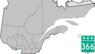
Route 366 is a secondary highway in the Outaouais region of Quebec. It runs from Route 301 near Creemorne in the Pontiac to Route 148 in the city of Gatineau.

<span class="mw-page-title-main">2017 Quebec floods</span> Weather event in Quebec, Canada

Spring snowfall and heavy rain caused floods in southern Quebec on 3 May 2017. In total, 5,371 residences were flooded, 4,066 people were forced from their homes, and 261 municipalities were affected, largely in the Outaouais Region, the Greater Montreal Area, the Montérégie, the Mauricie, the Gaspésie and the Côte-Nord regions. The floods were listed as the third most significant weather event of 2017 by the Canadian Meteorological and Oceanographic Society.

References

  1. 1 2 "Répertoire des autoroutes du Québec - Transports et Mobilité durable Québec". Ministère des Transports (in Canadian French). Gouvernement du Québec. Retrieved April 26, 2023.
  2. 1 2 Google (June 8, 2023). "Quebec Autoroute 50" (Map). Google Maps . Google. Retrieved June 8, 2023.
  3. "Ouverture du dernier tronçon de l'autoroute 50 | Ottawa–Gatineau" (in French). Radio-Canada. 2012-11-26. Retrieved 2012-12-04.
  4. "L'autoroute 50 est bel et bien une autoroute, soutient le MTQ | Ottawa–Gatineau" (in French). Radio-Canada. 2012-11-27. Retrieved 2012-12-04.
  5. "Highway 50 to be renamed after hockey legend Guy Lafleur". CBC News. April 30, 2023. Retrieved May 4, 2023.
  6. Boulay, Mathieu (May 4, 2023). "L'autoroute 50 devient l'autoroute Guy-Lafleur" [Autoroute 50 becomes Autoroute Guy-Lafleur]. Le Journal de Montréal (in French). Retrieved May 4, 2023.
  7. "Gatineau man, 61, dies in 14-vehicle crash". CBC News. 2007-03-15.
  8. Communiqué: L'Autoroute 50 - Commission de toponymie Archived April 24, 2008, at the Wayback Machine , retrieved September 3, 2007
  9. St-Denis, Yanick. "A-50 | Bientôt une autoroute Guy-Lafleur?". 104.7 Outaouais (in French). Retrieved 2022-05-17.
  10. Cantin, Alexandre Robillard, Violette (2022-04-23). "Québec envisage de renommer l'autoroute 50 en l'honneur de Guy Lafleur". Le Devoir (in French). Retrieved 2022-05-17.{{cite web}}: CS1 maint: multiple names: authors list (link)
  11. Deschatelets, Ani-Rose. "L'autoroute 50 sera renommée l'autoroute Guy-Lafleur". Le Droit (in French). Retrieved 2023-04-30.
  12. "L'autoroute 50 deviendra officiellement l'autoroute Guy-Lafleur". DansLesCoulisses.com (in Canadian French). 2023-04-28. Retrieved 2023-04-30.
Template:Attached KML/Quebec Autoroute 50
KML is from Wikidata