
Antoine-Labelle is a regional county municipality located in the Laurentides region of Quebec, Canada. Its seat is Mont-Laurier. It is named for Antoine Labelle.
Area codes 819, 873, and 468 are overlay telephone area codes in the North American Numbering Plan (NANP) for central and western Quebec, Canada, including the Quebec portion of the National Capital Region, and the Hudson Strait and Ungava Bay coastlines of Quebec. Major cities in the territory include Gatineau, Sherbrooke, Trois-Rivières, Drummondville, Shawinigan, Victoriaville, Rouyn-Noranda, Val-d'Or, Magog and Mont-Laurier.

Les Chenaux is a regional county municipality in central Quebec, Canada, in the Mauricie region. The seat is in Saint-Luc-de-Vincennes. It is located adjacent on the east of Trois-Rivières on the Saint Lawrence River. It has a land area of 872.04 square kilometres (336.70 sq mi) and a population of 17,865 inhabitants in the Canada 2011 Census. Its largest community is the parish of Notre-Dame-du-Mont-Carmel.
Autoroute 20 is a Quebec Autoroute, following the Saint Lawrence River through one of the more densely populated parts of Canada, with its central section forming the main route of the Trans-Canada Highway from the A-25 interchange to the A-85 interchange. At 585 km (363.5 mi), it is the longest Autoroute in Quebec. It is one of two main links between Montreal and Quebec City; the other is the A-40.
Autoroute 15 is a highway in western Quebec, Canada. It is also called the Décarie Expressway (English) or Autoroute Décarie (French) between the Turcot and Décarie Interchanges in Montreal and the Laurentian Autoroute (English) or Autoroute des Laurentides (French) north of Autoroute 40. It was, until the extension of Autoroute 25 was opened in 2011, the only constructed north-south autoroute to go out of Montreal on both sides. A-15 begins at the end of Interstate 87 at the United States border at Saint-Bernard-de-Lacolle and extends via Montreal to Sainte-Agathe-des-Monts with an eventual continuation beyond Mont-Tremblant. The total length of A-15 is currently 164 km (101.9 mi), including a short concurrency with Autoroute 40 that connects the two main sections. It is one of the few autoroutes in Quebec that does not have any spinoff highways.

Route 148 is an east-west highway in Quebec, Canada. It runs from junction of Autoroute 13 and Autoroute 440 in Laval in the Montreal region to the Ontario-Quebec border in L'Isle-aux-Allumettes in western Quebec. For most of its length, Route 148 follows the north shore of the Ottawa River where it acted as the principal route between communities in the Outaouais region until the completion of Autoroute 50 in 2012. At the Ontario-Quebec border in L'Isle-aux-Allumettes Route 148 continues into Ontario as Highway 148.

Route 216 is a two-lane east/west highway in Quebec, Canada, which starts in Sainte-Catherine-de-Hatley in the Estrie region at the junction of Route 108 and ends in Sainte-Perpétue in Chaudière-Appalaches at the junction of Route 204.

Route 232 is a two-lane east/west provincial highway on the south shore of the St. Lawrence River in the Bas-Saint-Laurent region of Eastern Quebec, Canada. Its eastern terminus is in Rimouski at the junction of Route 132 and the western terminus is at the junction of Route 289 in Rivière-Bleue. The route temporarily becomes A-85 along a 3 kilometre section through Cabano.
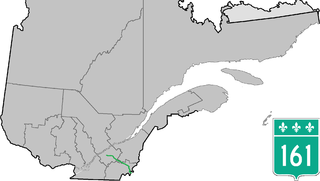
Route 161 is a north/south highway south of the St. Lawrence River in the regions of Centre-du-Québec, Chaudière-Appalaches and Estrie in the province of Quebec, Canada. Its current northern terminus is at Autoroute 20 in Sainte-Eulalie, just east of the junction of Autoroute 55, while its southern terminus is at the border of Maine in the USA, where it continues as Maine State Route 27. Previously the highway continued to Route 155 in Saint-Célestin, but that section was decommissioned in 2006 when Autoroute 55 was completed.

Route 157 is a four-lane north–south highway on the north shore of the Saint Lawrence River in Quebec, Canada. Its northern terminus is in Shawinigan at the junction of Route 153, and the southern terminus is at the junction of Route 138 in Cap-de-la-Madeleine, now part of Trois-Rivières.

Route 117, the Trans Canada Highway Northern Route, is a provincial highway within the Canadian province of Quebec, running between Montreal and the Quebec/Ontario border where it continues as Highway 66 east of McGarry, Ontario. It is an important road since it is the only direct route between southern Quebec and the Abitibi-Témiscamingue region.

Route 283 is a 73 km (?) two-lane north/south highway in the Chaudière-Appalaches region in the province of Quebec, Canada. Its northern terminus is in Montmagny at the junction of Route 132 and its southern terminus is close to Saint-Lucie-de-Beauregard at the junction of Route 204.
Autoroute 85 is a Quebec Autoroute and the route of the Trans-Canada Highway in the province's Bas-Saint-Laurent region, also known as Autoroute Claude-Béchard. It is currently under construction with committed Federal and Provincial funding for its completion, with an estimated completion date of 2026. Once this upgrade is completed, it will close the last gap in the nearly continuous freeway section of the Trans-Canada between Arnprior, Ontario, and Antigonish, Nova Scotia, and for an even longer interprovincial freeway route between Windsor, Ontario and Halifax, Nova Scotia. Running between Rivière-du-Loup and a junction with New Brunswick Route 2 at the Quebec-New Brunswick border, A-85 when complete will be the only controlled access highway link between the Maritime Provinces and the rest of the country. A-85 is projected to be approximately 100 km (60 mi) long when construction is complete and is intended to replace Route 185, which has been called one of the deadliest highways in Canada.

Route 309 is a provincial highway located in the Outaouais region in western Quebec. It starts at the junction of Autoroute 50 in the Buckingham sector, in the city of Gatineau's east end. It runs mostly parallel to the Du Lièvre River and ends north of Mont-Laurier in the town of Sainte-Anne-du-Lac in the Upper Laurentians.

Mont-Tremblant National Park is a provincial park in Canada located north of the town of Mont-Tremblant, and the village of Saint-Donat and Saint-Côme, in the administrative regions of Laurentides and Lanaudière, in Quebec, in Canada.

Route 311 is a provincial highway located in the Laurentides region of Quebec. The 77 kilometer-highway runs from south to north from the junction of Route 309 in Notre-Dame-de-Pontmain to Mont-Saint-Michel also at the junction of Highway 309. It is briefly concurrent with Route 117 at Beaux-Rivages and Lac-des-Écorces.

Route 327 is a provincial highway located in the Laurentides region of Quebec. The 90-kilometer highway runs from St-André-d'Argenteuil at the junction of Route 344 to Mont-Tremblant just west of the Provincial Park of the same name. The route serves as the main connection between Argenteuil county and the popular tourist region of the Upper Laurentides. In Lachute it is briefly concurrent with Highway 148. It is also concurrent with Route 364 between Weir and Arundel. Significant portions of this highway are meandering and have a maximum speed limit of 70 km/h.
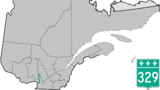
Route 329 is a provincial highway in the Laurentides and Lanaudière regions of Quebec, serving a large portion of the popular tourist area as well as numerous lakes and cottage areas in the Middle and Upper Laurentians. Beginning at the junction of Route 148 just east of Lachute, it ends 93 kilometers further north at the junction of Route 125 in Saint-Donat, just south of Mont-Tremblant National Park. It is briefly concurrent with Route 364 in Morin-Heights and Route 117 in Sainte-Agathe-des-Monts.
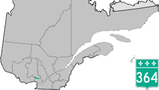
Route 364 is a Quebec provincial highway located in the Laurentides region. It runs from the junction of Autoroute 15 in the village of Saint-Sauveur, one of the major touristic villages in the Laurentides and ends in Amherst at the junction of Route 323. It overlaps Route 329 in Morin Heights and Route 327 from Weir to Arundel. Although well-maintained for most of its run, the approaches to Lac-des-Seize-Îles and Weir are marked by severe gradients, tight curves and are considered dangerous.
The Centre de services scolaire des Laurentides is a francophone school service centre in the Canadian province of Quebec, headquartered in Sainte-Agathe-des-Monts. It comprises several primary schools and high schools across municipalities in the Laurentides region. The commission is overseen by a board of elected school trustees.


