Autoroutes of Quebec | |
---|---|
System information | |
Maintained by Transports Quebec (MTQ) | |
Length | 2,381.9 km [1] [2] (1,480.0 mi) |
Formed | 1958 |
System links | |
The autoroute system is a network of freeways within the province of Quebec, Canada, operating under the same principle of controlled access as the Interstate Highway System in the United States and the 400-series highways in neighbouring Ontario. The Autoroutes are the backbone of Quebec's highway system, spanning almost 2,400 km (1,491 mi). The speed limit on the Autoroutes is generally 100 km/h (62 mph) in rural areas and 70–90 km/h (43–56 mph) in urban areas; most roads are made of asphalt concrete.
The word autoroute is a blend of auto and route , equivalent to "freeway" or "motorway" in English, and it became the equivalent of "expressway" in French. In the 1950s, when the first Autoroutes were being planned, the design documents called them autostrades from the Italian word autostrada . [3]
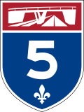
Autoroutes are identified by blue-and-red shields, similar to the American Interstate system. The red header of the shield contains a white image representing a highway overpass, and the blue lower portion of the shield contains the Autoroute's number in white, along with a fleur-de-lis, which is a provincial symbol of Quebec.
Most Autoroute and road traffic signs in the province are in French, though English is also used on federally-financed or -owned routes, such as the Bonaventure Expressway in Montreal. To surmount the language barrier, however, most signs in Quebec use pictograms and text is avoided in most cases, with the exceptions usually only being the names of control cities. Other exceptions that are posted in both languages is the illegal use of radar detectors when entering the province that reads "DÉTECTEURS DE RADAR INTERDITS/RADAR DETECTORS PROHIBITED", as well as areas where roads can be slippery due to melting ice and snow, marked "DEGEL/THAW".
Autoroutes are divided into three types – principal routes, deviation routes, and collector routes – and are laid out and numbered in a fashion similar to the Interstate Highway System in the United States. The principal Autoroutes are the major highways of the province, and have single- or double-digit numbers. East-west Autoroutes running parallel to the Saint Lawrence River (for example, Autoroute 20 and Autoroute 40) are assigned even numbers, while north-south Autoroutes running perpendicular to the Saint Lawrence (such as Autoroute 5 and Autoroute 15) are given odd numbers. Deviation and collector Autoroutes both feature triple-digit numbers. Deviation routes are bypasses intended for truck traffic to circumvent urban areas, and are identified by an even number prefixing the number of the nearby Autoroute that it bypasses (for example, Autoroute 440 in Laval). Collector Autoroutes, by contrast, are spur routes into urban areas, and are identified by an odd number prefixing the number of the nearby Autoroute that it branches off of (such as Autoroute 720, a spur of Autoroute 20 into downtown Montreal).
Quebec's first Autoroute was the Autoroute des Laurentides (Laurentian Autoroute), which opened in 1959 as a toll road. This initiative to bring freeways into Quebec was started by Maurice Duplessis, whose government saw the construction of the Laurentian Autoroute (now A-15) from Montreal to Saint-Jérôme and the first section of the Boulevard Métropolitain (A-40), which opened in 1960.
It was the Quebec Liberal government of the 1960s that saw the construction of further Autoroutes, with a grid numbering system and the introduction of the blue and red shield. The sign is inspired by the American Interstate sign. This was especially needed in light of the fact that many visitors would be flocking to Montreal by car for Expo 67. Montreal's Autoroute Décarie (A-15) and the Louis-Hippolyte Lafontaine Bridge–Tunnel were constructed for that very reason. The Autoroute des Cantons-de-l'Est (Eastern Townships Autoroute - A-10) opened in 1964, and its continuation, A-55 between Magog and Rock Island, opened in 1967, connecting with Interstate 91. What are now the A-20 (part of the Trans-Canada Highway) and the A-15 to New York (connecting with Interstate 87), originally built in the 1940s, were upgraded to expressway standards. The A-20 also connects with Highway 401 in Ontario. A-40 was extended out to Berthierville, and later to Trois-Rivières in the 1970s. Others include Autoroutes 25, 30 (southern beltway), 31, 35 (eventually connecting to Interstate 89), Autoroute Laurentienne (73), and 640 (an unfinished proposed northern beltway).
The 1970s also saw the completion of the Pierre Laporte Bridge in Quebec City, connecting the south shore of the Saint Lawrence River to the north. In addition to this, the A-73 was extended to Beauce, the A-20 was extended to Rivière-du-Loup, and the Chomedey Autoroute (A-13), the A-19 and the A-440 were constructed in Laval. Autoroutes were built (two sections of A-440, and A-740) and a few more planned in the Quebec City region, creating a dense web, which led to significant sprawl. In 1976, the Parti Québécois came to power, whose platform mandated an expansion of public transportation over the construction of more Autoroutes. Existing Autoroutes were extended (e.g., the A-40 was extended from Trois-Rivières to Quebec City) but no new Autoroutes were built.
The Autoroute des Laurentides, the Autoroute des Cantons-de-l'Est, the Autoroute de la Rive-Nord (North Shore Autoroute), and the A-13 were toll roads until the mid-1980s, when the toll barriers were removed and the province stopped collecting tolls from vehicles using the Autoroutes. The last toll booth was on the Champlain Bridge (A-10,A-15 and A-20). It was removed in 1990 because the Champlain Bridge is federal property and is thus not subject to provincial tolls.
In the 2000s, there were several high-profile failures and collapses around some Autoroutes, due to aging and crumbling infrastructure, including the Boulevard du Souvenir overpass collapse, De la Concorde overpass collapse, and most recently the Ville-Marie tunnel collapse. An online poll by Léger Marketing conducted shortly after the Viger tunnel collapse found that 88 percent of Montrealers are "worried" about the state of roads, bridges and tunnels in the city, with more than half of respondents saying they are downright "scared" to drive under an overpass (58 percent), on a bridge (54 per cent), or through a tunnel (53 per cent). McGill University's Saeed Mirza stated that ill-advised design choices and poor-quality concrete were used in the construction rush ahead of Expo '67 and the 1976 Olympics. In particular, the concrete used was permeable with lack of proper drainage, and these allowed chlorides from de-icing salts to corrode the steel reinforcements. [4]
Number | Length (km) [2] [1] | Length (mi) | Southern or western terminus | Northern or eastern terminus | Local names | Formed [2] | Removed | Notes |
---|---|---|---|---|---|---|---|---|
A-5 | 34.0 | 21.1 | King Edward Avenue at Ontario boundary in Gatineau | R-105 / R-366 in Wakefield | Autoroute de la Gatineau | 1964 | current | |
A-6 | 55 | 34 | A-15 in La Prairie | Route 235 in Farnham | Richelieu Autoroute, Autoroute Haut-Richelieu | — | — | A-6 was to roughly parallel Route 104. The western half of the route was cancelled by the mid-1970s while the rest of the route was abandoned a few years later. |
A-9 | 12 | 7.5 | A-40 in Pointe-Fortune | A-50 in Lachute | Pointe Fortune-Lachute Autoroute | — | — | A-9 was to provide a fixed crossing over the Ottawa River but was cancelled. |
A-10 | 145.1 [5] | 90.2 | R-136 in Montreal | A-55 / A-610 in Sherbrooke | Autoroute Bonaventure, Autoroute des Cantons-de-l'Est | 1962 | current | |
A-13 | 21.4 | 13.3 | A-20 in Lachine | A-640 in Boisbriand | Autoroute Chomedey | 1975 | current | |
A-15 (TCH) | 164.0 | 101.9 | I-87 at United States border at Lacolle | R-117 (TCH) in Sainte-Agathe-des-Monts | Autoroute Décarie, Autoroute des Laurentides | 1958 | current | Part of the Trans-Canada Highway between A-40 in Montreal and Sainte-Agathe-des-Monts. |
A-16 | 9 | 5.6 | R-134 | A-30 in Longueuil | Autoroute Wilfrid-Laurier | — | — | Reserved for autoroute conversion of Boulevard Wilfrid-Laurier (Route 112 and Route 116). |
A-18 | — | — | A-55 near Victoriaville | Proposed A-65 in Plessisville | Autoroute des Bois-Francs | — | — | Unbuilt. |
A-19 | 10.1 | 6.3 | A-40 (TCH) in Montreal | A-440 / R-335 in Laval | Autoroute Papineau | 1970 | current | |
A-20 (TCH) | 534.5 | 332.1 | Highway 401 at Ontario border at Rivière-Beaudette | R-132 in Notre-Dame-des-Neiges | Autoroute Jean-Lesage, Autoroute du Souvenir | 1964 | current | Part of the Trans-Canada Highway between A-25 in Longueuil and A-85 in Rivière-du-Loup. |
A-20 | 45.2 | 28.1 | R-132 in Rimouski | R-132 in Mont-Joli | Autoroute Jean-Lesage | 1991 | current | Future plans to connect to the western segment. |
A-25 (TCH) | 52.1 | 32.4 | A-20 (TCH) in Longueuil | R-125 / R-158 in Saint-Esprit | Autoroute Louis-Hippolyte-La Fontaine | 1967 | current | Part of the Trans-Canada Highway between A-40 in Montreal and A-20 in Longueuil. |
A-30 | 144.1 | 89.5 | A-40 (TCH) in Vaudreuil-Dorion | R-132 in Sorel-Tracy | Autoroute de l'Acier | 1968 | current | |
A-30 | 20.8 | 12.9 | R-132 in Bécancour | R-132 in Bécancour | Autoroute de l'Acier | 1975 | current | No plans to connect to the western segment. |
A-31 | 14.3 | 8.9 | A-40 / R-131 in Lavaltrie | R-131 / R-158 in Joliette | Autoroute Antonio-Barrette | 1966 | current | |
A-35 | 41.4 | 25.7 | R-133 in Saint-Sébastien | A-10 in Chambly | Autoroute de la Vallée-des-Forts | 1966 | current | Future extension to United States border and I-89 . |
A-40 (TCH) | 347 | 216 | Highway 417 / TCH at Ontario border near Pointe-Fortune | R-138 / R-368 near Boischatel | Autoroute Félix-Leclerc, Autoroute Métropolitaine, Autoroute Transcanadienne | 1959 | current | Part of the Trans-Canada Highway between Ontario and A-25 in Montreal. |
A-50 | 159 | 99 | Rue Montcalm in Gatineau | R-117 near Mirabel | Autoroute de l'Outaouais, Autoroute Maurice-Richard | 1975 | current | |
A-51 | 45 | 28 | Route 116 near Melbourne | A-20 in Drummondville | 1974 | 1982 | Renamed A-55 . | |
A-55 | 247 | 153 | I-91 at United States border at Stanstead | R-155 in Shawinigan | Autoroute Joseph-Armand-Bombardier, Autoroute de l'énergie | 1964 | current | |
A-65 | — | — | Thetford Mines | A-20 in Villeroy | Autoroute de l'Amiante | — | — | Unbuilt. Possible extension to A-10 near Lambton. |
A-70 | 31.56 | 19.61 | R-170 in Saguenay (Jonquière) | R-170 in Saguenay (Aéroport Bagotville) | Autoroute du Saguenay, Autoroute Alma-La Baie | 1983 | current | Autoroute 70 is being extended westward from Jonquière to Alma, and eastward from Aéroport CFB Bagotville to La Baie. |
A-73 | 135.0 | 83.9 | R-204 in Saint-Georges | R-175 in Stoneham-et-Tewkesbury | Autoroute Robert-Cliche, Autoroute Laurentienne, Autoroute Henri-IV | 1963 | current | |
A-85 (TCH) | 62.9 | 39.1 | Route 2 (TCH) at New Brunswick border near Dégelis | A-20 (TCH) near Rivière-du-Loup | Autoroute Claude-Béchard | 2005 | current | Part of the Trans-Canada Highway for its full length. Presently a 35 km (22 mi) gap between Saint-Antonin and Saint-Louis-du-Ha! Ha!; connection made via Route 185 , which it will eventually replace. |
|
Number | Length (km) [2] [1] | Length (mi) | Southern or western terminus | Northern or eastern terminus | Local names | Formed [2] | Removed | Notes |
---|---|---|---|---|---|---|---|---|
A-410 | 12.9 | 8.0 | R-108 / R-143 in Sherbrooke | A-10 / A-55 in Sherbrooke | Autoroute Jacques-O'Bready, Autoroute de l'Université | 1971 | current | |
A-415 | 7 | 4.3 | A-15 in Montréal | A-19 (unbuilt section) in Montreal | Mount Royal Autoroute | — | — | Cancelled northern leg of a proposed downtown freeway loop. |
A-430 | — | — | A-15 / A-30 in Candiac | A-30 in Varennes | — | — | Several kilometers of Route 132 north and south of A-20 was designated A-430 on paper in the 1970s. | |
A-440 | 18.2 | 11.3 | A-13 / R-148 in Laval | A-25 in Laval | Autoroute Jean-Noël-Lavoie, Autoroute Laval | 1974 | current | |
A-440 | 12.5 | 7.8 | A-40 / A-73 in Québec | A-40 in Québec | Autoroute Charest, Autoroute Dufferin-Montmorency | 1962 | current | Two segments with a 4 km (2.5 mi) gap through downtown Quebec City; connection made via Boulevard Charest. |
A-520 | 7.8 | 4.8 | A-20 in Dorval | A-40 (TCH) in Montréal | Autoroute Côte de Liesse | 1966 | current | |
A-530 | 12.9 | 8.0 | R-132 / R-201 in Salaberry-de-Valleyfield | A-30 in Salaberry-de-Valleyfield | 2012 | current | Formerly part of A-30 . | |
A-540 | 5.1 | 3.2 | A-73 / R-175 in Québec | R-138 in Québec | Autoroute Duplessis | 1966 | current | |
A-540 | 4.9 | 3.0 | A-20 in Vaudreuil-Dorion | A-40 in Vaudreuil-Dorion | 1967 | 2012 | Renamed A-30 . | |
A-550 | — | — | Ontario boundary in Gatineau (Would continue as Highway 416 in Ottawa) | A-50 in Gatineau | Deschênes Autoroute, Britannia-Deschênes corridor | — | — | Gatineau bypass, including a new bridge across the Ottawa River. |
A-573 | 12.9 | 8.0 | A-40 / A-73 in Québec | R-369 in Québec | Autoroute Henri-IV | 1976 | current | |
A-610 | 10.3 | 6.4 | A-10 / A-55 in Sherbrooke | R-112 in Sherbrooke | Autoroute Louis-Bilodeau | 2006 | current | Formerly part of A-10 . |
A-640 | 53.2 | 33.1 | R-344 in Oka | R-344 in Charlemagne | Autoroute de contournement nord de Montréal | 1961 | current | |
A-720 | 8.1 | 5.0 | A-15 / A-20 in Montréal | Rue Notre-Dame in Montréal | Autoroute Ville-Marie | 1972 | [6] | 2021Renamed R-136 . |
A-730 | 4.2 | 2.6 | A-30 in Saint-Constant | R-132 in Saint-Constant | 2012 | current | Formerly part of A-30 . | |
A-740 | 7.4 | 4.6 | R-175 in Quebec | Boulevard Lebourgneuf in Québec | Autoroute Robert-Bourassa, Autoroute du Vallon | 1975 | current | |
A-755 | 10 | 6.2 | A-55 in Trois-Rivières | A-40 in Trois-Rivières | Autoroute de Francheville | 1977 | 1990 | c.Renamed A-40 . |
A-930 | 2.5 | 1.6 | A-30 in Candiac | R-132 in Candiac | 2012 | current | Formerly part of A-30 . | |
A-955 | 15.9 | 9.9 | Rue Principale in Saint-Albert | A-20 (TCH) / A-55 in Sainte-Eulalie | 1975 | current | None of this highway is of freeway standard. | |
A-973 | 3.6 | 2.2 | Rue du Chalutier / Rue du Prince-Édouard in Quebéc | A-40 / A-73 in Quebec | 1983 | current | Cosigned with Route 175 for its entire length. | |
|
The Trans-Canada Highway is a transcontinental federal–provincial highway system that travels through all ten provinces of Canada, from the Pacific Ocean on the west coast to the Atlantic Ocean on the east coast. The main route spans 7,476 km (4,645 mi) across the country, one of the longest routes of its type in the world. The highway system is recognizable by its distinctive white-on-green maple leaf route markers, although there are small variations in the markers in some provinces.
Léon Gozlan was a 19th-century French novelist and playwright.
Autoroute 20 is a Quebec Autoroute, following the Saint Lawrence River through one of the more densely populated parts of Canada, with its central section forming the main route of the Trans-Canada Highway from the A-25 interchange to the A-85 interchange. At 585 km (363.5 mi), it is the longest Autoroute in Quebec. It is one of two main links between Montreal and Quebec City; the other is the A-40.
Autoroute 15 is a highway in western Quebec, Canada. It was, until the extension of Autoroute 25 was opened in 2011, the only constructed north-south autoroute to go out of Montreal on both sides. A-15 begins at the end of Interstate 87 at the United States border at Saint-Bernard-de-Lacolle and extends via Montreal to Sainte-Agathe-des-Monts with an eventual continuation beyond Mont-Tremblant. The total length of A-15 is currently 164 km (101.9 mi), including a short concurrency with Autoroute 40 that connects the two main sections. This is one of the few autoroutes in Quebec that does not have any spinoff highways.
Autoroute 25 is an Autoroute in the Lanaudière region of Quebec. It is currently 49 km (30.4 mi) long and services the direct north of Montreal's Metropolitan Area. A-25 has one toll bridge, which is the first modern toll in the Montreal area and one of two overall in Quebec.
Autoroute 50 is an Autoroute in western Quebec, Canada. It links Canada's National Capital Region (Gatineau) and the Greater Montreal area (Mirabel).
Autoroute 10 (A-10) is an Autoroute of Quebec in Canada that links greater Montreal to key population centres in Montérégie and Estrie, including Brossard, Saint-Jean-sur-Richelieu, Granby, and Sherbrooke.
Autoroute 35 (A-35) is an Autoroute in the region of Montérégie, Quebec, Canada. Constructed in the 1960s, the A-35 links Saint-Jean-sur-Richelieu with Montreal via the A-10. The A-35 is also the primary route for traffic between Montreal and Boston, although it ends 13.4 km (8.3 mi) short of the U.S. border. South of its current terminus in Saint-Sébastien, the A-35 continues as two-lane Route 133 to the border. An extension of A-35 to meet Interstate 89 at Saint-Armand will complete a nearly 500 km (310 mi) limited-access highway link between Montreal and Boston. It had been scheduled to open in 2017, but construction was on hold and now will be completed up to the Canada-US border by the end of 2023.
Route 136 (R-136), formerly Autoroute 720, known as the Ville-Marie Expressway (English) or Autoroute Ville-Marie (French) is an Autoroute highway in the Canadian province of Quebec that is a spur route of Autoroute 20 in Montreal. Its western terminus is located at the Turcot Interchange, a junction with Autoroute 15 and Autoroute 20, and its eastern terminus is near the Jacques Cartier Bridge, where the highway merges with Notre-Dame Street. The Autoroute Ville-Marie designation is named after the downtown borough of Ville-Marie, through which the expressway is routed. It was designated Autoroute 720 until 2021 when it was renamed to Route 136.
Autoroute 30 (A-30), or the Autoroute de l'Acier is an Autoroute in Quebec, Canada. Construction of the A-30 dates back to the early days of autoroute construction in the 1960s. Originally called Highway 3, the A-30 was designed to replace Route 132 as the main artery linking the communities along the South Shore of the St. Lawrence River. The A-30 was originally intended to begin at the U.S. border near Dundee and end at Saint-Pierre-les-Becquets. In the late 1970s an eight-year moratorium on new autoroute construction in favour of public transport by the Parti Québécois prevented implementation of that plan.
Autoroute 19, also known as Autoroute Papineau, is an autoroute in Quebec. It crosses the Rivière des Prairies via the Papineau-Leblanc Bridge, connecting the borough of Ahuntsic-Cartierville in Montreal and the Duvernay neighbourhood in Laval.
Comptes rendus de l'Académie des Sciences, or simply Comptes rendus, is a French scientific journal that has been published since 1835. It is the proceedings of the French Academy of Sciences. It is currently split into seven sections, published on behalf of the Academy by Elsevier: Mathématique, Mécanique, Physique, Géoscience, Palévol, Chimie, and Biologies.
Marie Henri Andoyer was a French astronomer and mathematician.
This article describes the highway systems available in selected countries.
Raymond Brucker, full name Raymond Philippe Auguste Brucker, was a 19th-century French writer.
The réseau routier québécois is managed by the Quebec Ministry of Transportation and consists of about 185,000 kilometres (115,000 mi) of highways and roads. In addition, Quebec has almost 12,000 bridges, tunnels, retaining walls, culverts, and other structures such as the Quebec Bridge, the Pierre Laporte Bridge, the Laviolette Bridge and the Louis-Hippolyte Lafontaine Bridge–Tunnel.
André Joly was a court painter from Lorraine. His last name was also spelled Jolly. Born in Saint-Nicolas-de-Port, his place of death and year is uncertain, but presumed to be in Paris after 1781.