
Saint-Eustache is an off-island suburb of Montreal, in western Quebec, Canada, west of Montreal on the north shore of the Rivière des Mille Îles. It is located 35 km (22 mi) northwest of Montreal.
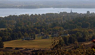
Oka is a small village on the northern bank of the Ottawa River, northwest of Montreal, Quebec, Canada. Located in the Lower Laurentians on Lake of Two Mountains, where the Ottawa has its confluence with the St. Lawrence River, the town has a main thoroughfare that is now part of Quebec Route 344. It's located 50 km northwest of Montreal.
The 2000–2006 municipal reorganization in Quebec resulted in large-scale amalgamation (merging) of smaller municipalities in Quebec into larger cities. It was undertaken by one administration, and modified and partially undone by its successor.

Argenteuil—Papineau—Mirabel was a federal electoral district in Quebec, Canada, that was represented in the House of Commons of Canada from 1867 to 2015.

Mascouche is a commuter railway line in Greater Montreal, Quebec, Canada. It is operated by Exo, the organization that operates public transport services across this region.
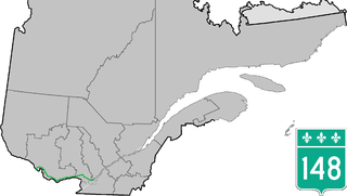
Route 148 is an east-west highway in Quebec, Canada. It runs from junction of Autoroute 13 and Autoroute 440 in Laval in the Montreal region to the Ontario-Quebec border in L'Isle-aux-Allumettes in western Quebec. For most of its length, Route 148 follows the north shore of the Ottawa River where it acted as the principal route between communities in the Outaouais region until the completion of Autoroute 50 in 2012. At the Ontario-Quebec border in L'Isle-aux-Allumettes Route 148 continues into Ontario as Highway 148.

Route 289 is a two-lane north/south highway on the south shore of the Saint Lawrence River in the Bas-Saint-Laurent region of eastern Quebec, Canada. Its northern terminus is in Saint-André at the junction of Route 132 and the southern terminus is at the border of New Brunswick where it continues as Route 120.

Route 117 is a provincial highway within the Canadian province of Quebec, running between Montreal and the Quebec/Ontario border where it continues as Highway 66 east of Kearns, Ontario. It is an important road as it is the only direct route between southern Quebec and the Abitibi-Témiscamingue region.

Route 170 is a major east/west highway on the north shore of the St. Lawrence River in Quebec, Canada, and it parallels the Saguenay River on the south side of it. The western terminus of Route 170 is in Métabetchouan–Lac-à-la-Croix at the junction of Route 169, at Lac Saint-Jean, and the eastern terminus is in Saint-Siméon, at the junction of Route 138, close to the Saint Lawrence River.
Mirabel is a provincial electoral district in Quebec, Canada that elects members to the National Assembly of Quebec. It includes the municipalities of Mirabel, Oka, Pointe-Calumet, Saint-Joseph-du-Lac, Sainte-Marthe-sur-le-Lac and Saint-Placide and the Mohawk community of Kanesatake.

Grenville-sur-la-Rouge is a municipality in the Argenteuil Regional County Municipality in the Laurentides region of Quebec, Canada. It is a predominantly Francophone community situated along the southern border of Quebec between Montreal and Ottawa.
Argenteuil is a provincial electoral district in the Laurentides region of Quebec, Canada that elects members to the National Assembly of Quebec. It includes the cities of Saint-Colomban, Lachute, and Brownsburg-Chatham.

The Sir Wilfrid Laurier School Board is a school board headquartered in Rosemère, Quebec in Greater Montreal.

Route 327 is a provincial highway located in the Laurentides region of Quebec. The 90-kilometer highway runs from St-André-d'Argenteuil at the junction of Route 344 to Mont-Tremblant just west of the Provincial Park of the same name. The route serves as the main connection between Argenteuil county and the popular tourist region of the Upper Laurentides. In Lachute it is briefly concurrent with Highway 148. It is also concurrent with Route 364 between Weir and Arundel. Significant portions of this highway are meandering and have a maximum speed limit of 70 km/h.

Route 341 is a Quebec provincial highway located in the Lanaudière region northeast of Montreal. It runs from south to north from Repentigny just south of the junction of Autoroute 40 and ends 55 kilometers north at the junction of Route 125 northwest of Rawdon, Quebec. It overlaps Route 337 and Route 348 in Rawdon and Route 346 east of Sainte-Julienne
The North Shore is the general term for the northern suburbs of Montreal. The North Shore is located in southwestern Quebec on the northern shores of the Rivière des Prairies and the Rivière des Mille Îles, opposite the Island of Montreal and the Island of Laval. It consists of twenty municipalities that belong to the Laurentides and Lanaudière administrative regions. While the city of Laval is commonly associated with the North Shore, it is not considered part of the North Shore because of its status as an island.

Pointe-Calumet is a municipality in the Canadian province of Quebec. The municipality is located within the Deux-Montagnes Regional County Municipality in the Laurentides region. It is situated about 30 minutes northwest of Montreal. Its population as of the 2006 Canadian Census is just over 6 000.

Saint-Placide is a municipality in the Laurentides region of Quebec, Canada, part of the Deux-Montagnes Regional County Municipality, along the north shore of the Ottawa River.


