
Beauport—Côte-de-Beaupré—Île d'Orléans—Charlevoix is a federal electoral district in Quebec, Canada, that has been represented in the House of Commons of Canada since 2004. An earlier Charlevoix—Montmorency riding was represented in the House of Commons from 1917 to 1925.
Montmorency was a federal electoral district in the province of Quebec, Canada, that was represented in the House of Commons of Canada from 1867 to 1917, and from 1968 to 2004.
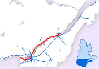
Autoroute 40, officially known as Autoroute Félix-Leclerc outside Montreal and Metropolitan Autoroute/Autoroute Métropolitaine within Montreal, is an Autoroute on the north shore of the St. Lawrence River in the Canadian province of Quebec. It is one of the two major connections between Montreal and Quebec City, the other being Autoroute 20 on the south shore of the St. Lawrence. Autoroute 40 is currently 347 km (215.6 mi) long. Between the Ontario–Quebec boundary and the interchange with Autoroute 25, the route is signed as part of the Trans-Canada Highway.

The Réseau de transport de la Capitale (RTC), brand name for Société de transport de Québec, provides urban public transit services in the Quebec City area. It was founded in 2001, continuing the operations of the former Société de transport de la communauté urbaine de Québec, as the latter was merged into the new Quebec City.

Autoroute 440 is a superhighway located in Quebec City. It includes two separate segments, respectively named Autoroute Charest and Autoroute Dufferin-Montmorency. Originally meant to be connected and form a single continuous highway via a tunnel under the city centre, these plans were shelved years ago and are not expected to be revived.

Route 368 is a 72 km two-lane east/west highway in Quebec, Canada, which is located on Île d'Orléans and includes the Pont de l'Île which connects the island to the mainland. It starts at the junction of Autoroute 40 at exit 325 in Beauport, now part of Quebec City, crosses the bridge and it follows around the island's perimeter, passing through all 6 villages on the island.
Provincial Highway 159 is a two-lane north/south highway on the north shore of the Saint Lawrence River in Quebec, Canada. Its northern terminus is in Saint-Roch-de-Mékinac at the junction of Route 155, and the southern terminus is at the junction of Route 138 in Sainte-Anne-de-la-Pérade.

Open from May to October, Canyon Sainte-Anne is a spectacular, steep-sided gorge, carved by the Sainte-Anne-du-Nord River, 6 km east of Beaupré, Quebec, Canada. The river drops over a 74 m (243 ft) waterfall within the canyon.
Montmorency is a provincial electoral district in the Capitale-Nationale region of Quebec, Canada. It comprises part of the Beauport borough of Quebec City and the municipality of Sainte-Brigitte-de-Laval.

Route 309 is a provincial highway located in the Outaouais region in western Quebec. It starts at the junction of Autoroute 50 in the Buckingham sector, in the city of Gatineau's east end. It runs mostly parallel to the Du Lièvre River and ends north of Mont-Laurier in the town of Sainte-Anne-du-Lac in the Upper Laurentians.

Route 209 is a provincial highway located in the Montérégie region of Quebec south of Montreal. The route runs from the Canada-United States border in Franklin and ends at the Saint-Constant/Sainte-Catherine limit, south of Montreal at the junction of Route 132. South of the US border it continues as New York State Route 189 in Clinton, New York. This road serves as an alternative route to Route 138 and the southwestern suburbs) which is a parallel route to Route 209 located roughly 10 kilometers west of it. It also provides the main link to Saint-Rémi, the largest city in the Jardins-de-Napierville MRC.

Route 358 is a provincial highway located in the Capitale-Nationale region of Quebec. It runs from the junction of Route 138 in Cap-Santé and ends in the Vanier sector of Quebec City also at the junction of Highway 138. The roadway passes north of the Jean-Lesage International Airport situated just west of the junctions of Autoroute 40, 73 and 573. West of the Airport it overlaps Route 367 as well as Route 365 in Pont-Rouge.

Route 369 is a provincial highway located in the Capitale-Nationale region in south-central Quebec. The highway runs from Sainte-Catherine-de-la-Jacques-Cartier and ends in the Beauport sector of Quebec City at the junctions of Autoroute 40 and Route 360. The highway serves also CFB Valcartier military base located just off Autoroute 573.

Route 381 is a provincial highway located in the Capitale-Nationale and Saguenay–Lac-Saint-Jean regions of Quebec. It runs from Baie-Saint-Paul at the junction of Route 138 and ends in the La Baie sector of the City of Saguenay at the junction of Route 170.
Route 136 is a provincial highway located in the Capitale-Nationale region of Quebec. The highway runs from Autoroute 440 to Autoroute 73 near the Pierre Laporte and Quebec bridges in Quebec City. A short route, most of Route 136 is a parkway along the Saint Lawrence River connecting the Basse-Ville of Old Quebec to the bridges. The eastern section follows city streets in that community.
Saint-Tite-des-Caps is a municipality in La Côte-de-Beaupré Regional County Municipality in Quebec, Canada. Located on Route 138 to Baie-Saint-Paul, this road climbs up sharply to about 700 meters (2,300 ft) to reach the town nestled in a valley. The Sainte-Anne-du-Nord River forms the municipal western boundary.

The Charlevoix Railway is a short-line railway that operates in the Charlevoix region of Quebec Canada. From 1994 to 2009 it was a subsidiary of the Quebec Railway Corporation, a short line operator. Since April 2009 it has been owned by Train touristique de Charlevoix Inc., a Groupe Le Massif Inc. subsidiary. With a length of 144–148 kilometres (89–92 mi) it connects the city of Clermont in the Charlevoix region to a freight yard of the Canadian National Railway (CN) located in the La Cité-Limoilou borough of the city of Quebec. The railway runs along both the St. Lawrence River and the Malbaie River and consists of a single non-electrified track.
The Malbaie is a freshwater body located in the administrative region of Capitale-Nationale, in the province of Quebec, in Canada. Lac Malbaie straddles the regional county municipalities (RCMs) of:
The Lombrette river is a tributary of the Sainte-Anne River flowing on the north bank of the Saint Lawrence River, in the administrative region of the Capitale-Nationale, in the province of Quebec, in Canada. This river flows consecutively through the regional county municipalities (MRC) of:
The rivière des Chenaux is a tributary of the Lombrette River flowing on the north shore of the Saint Lawrence river, in the administrative region of Capitale-Nationale, in the province of Quebec, in Canada. This river flows consecutively through the regional county municipalities (MRC) of:

