
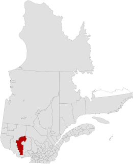
Antoine-Labelle is a regional county municipality located in the Laurentides region of Quebec, Canada. Its seat is Mont-Laurier. It is named for Antoine Labelle.

Portneuf is a regional county municipality (RCM) in the Capitale-Nationale administrative region of Quebec, Canada. RCM of Portneuf has been established on January 1, 1982. It is composed of 21 municipalities: nine cities, seven municipalities, two parishes and three unorganized territories. The county seat is located in Cap-Santé.
Labelle County is a historic county in western Quebec, Canada. Its county seat was Mont-Laurier, Quebec. It was bounded on the west by Gatineau County, on the northeast by Montcalm County, and on the south by Papineau County. In the early 1980s when Quebec's counties were abolished, most of Labelle County was transferred to Antoine-Labelle Regional County Municipality. The southeastern part was transferred to Les Laurentides Regional County Municipality.
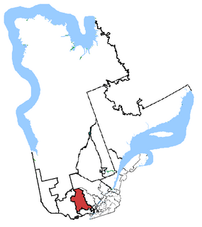
Laurentides—Labelle is a federal electoral district in Quebec, Canada, that has been represented in the House of Commons of Canada since 2004.

Joliette is a regional county municipality in the Lanaudière region of Quebec, Canada. Its seat is Joliette.
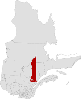
La Vallée-de-la-Gatineau(The Valley of the Gatineau) is a regional county municipality in the Outaouais region of western Quebec, Canada. The seat is in Gracefield. It was incorporated on January 1, 1983 and was named for its location straddling the Gatineau River north of Low.
Le Fjord-du-Saguenay is a regional county municipality in the Saguenay-Lac-Saint-Jean region of Quebec, Canada. Its seat is Saint-Honoré, which is also its most populous municipality.

L'Érable (Maple) is a regional county municipality in the Centre-du-Québec region of Quebec, Canada. Named for its maple trees, the area is rural in nature and is located 50 km southwest of Quebec City. Its seat is Plessisville.

Lotbinière is a regional county municipality in the Chaudière-Appalaches region of Quebec. It is an almost exclusively rural RCM, with no village with a population above 4,000. As of the 2016 Canadian Census, the RCM had a population of 31,741. Its seat is in Sainte-Croix.

Maskinongé is a regional county municipality in the Mauricie region of Quebec, Canada. The seat is Louiseville. It is located adjacent on the west of Trois-Rivières on the Saint Lawrence River.

Nicolet-Yamaska is a regional county municipality in the Centre-du-Québec region of Quebec, Canada.

Papineau is a regional county municipality in the Outaouais region of Quebec, Canada. The seat is Papineauville.

Caniapiscau is a regional county municipality in the Côte-Nord region of Quebec, Canada. The seat is Fermont.

Les Chenaux is a regional county municipality in central Quebec, Canada, in the Mauricie region. The seat is in Saint-Luc-de-Vincennes. It is located adjacent on the east of Trois-Rivières on the Saint Lawrence River. It has a land area of 872.04 square kilometres (336.70 sq mi) and a population of 17,865 inhabitants in the Canada 2011 Census. Its largest community is the parish of Notre-Dame-du-Mont-Carmel.

Route 317 is a provincial highway in the Papineau County of the Outaouais region east of Gatineau, Quebec. The 36-kilometer highway connects Thurso, at the junction of Route 148, to Ripon at the junction of Route 321. It is also a link to Montpellier in which a rural route connects both the 315 and 317 towards the village.

The Rouge River is a river flowing in the Laurentides, in the municipality of Grenville-sur-la-Rouge, in the Argenteuil Regional County Municipality, in the administrative region of Laurentides, in the west of Quebec, in western Quebec, Canada.

Route 117, the Trans Canada Highway Northern Route, is a provincial highway within the Canadian province of Quebec, running between Montreal and the Quebec/Ontario border where it continues as Highway 66 east of McGarry, Ontario. It is an important road since it is the only direct route between southern Quebec and the Abitibi-Témiscamingue region.

François-Xavier-Antoine Labelle was a Roman Catholic priest and the person principally responsible for the settlement of the Laurentians. He is also referred to as "Curé Labelle" and sometimes, the "King of the North."

La Minerve is a village and municipality in the Laurentides region of Quebec, Canada, part of the Les Laurentides Regional County Municipality.

The Bazin River is a river in Quebec, Canada, that flows from the La Tuque area of the La Tuque administrative authority of Mauricie to the Gatineau River in the unorganized territory of Lac-Oscar, in the Regional County Municipality (RCM) of Antoine-Labelle, in Laurentides.


