
La Mauricie National Park is a national park located near Shawinigan in the Laurentian mountains, in the Mauricie region of Quebec, Canada. It covers 536 km2 (207 sq mi) in the southern Canadian Shield region bordering the Saint Lawrence lowlands. The park contains 150 lakes and many ponds.

Antoine-Labelle is a regional county municipality located in the Laurentides region of Quebec, Canada. Its seat is Mont-Laurier. It is named for Antoine Labelle.

La Vérendrye wildlife reserve is one of the largest reserves in the province of Quebec, Canada, covering 12,589 square kilometres (4,861 sq mi) of contiguous land and lake area. It is named after Pierre Gaultier de Varennes, sieur de La Vérendrye, a French-Canadian explorer. Located 180 kilometres (110 mi) north of Ottawa, it is traversed from south to north by Route 117.

The Hautes-Gorges-de-la-Rivière-Malbaie National Park is a provincial park in the Charlevoix region of Quebec, Canada. Centring on the Malbaie River Gorge, it is the centrepiece of the UNESCO Charlevoix biosphere reserve. Despite its name, it is not in Canada's national park system, nor administered by Parks Canada. It is administered by the Société des établissements de plein air du Québec (Sépaq). The park can be reached via a local road, 30 kilometers (19 mi) northwards from Route 138 in Saint-Aimé-des-Lacs.

François-Xavier-Antoine Labelle was a Roman Catholic priest and the person principally responsible for the settlement of the Laurentians. He is also referred to as "Curé Labelle" and sometimes, the "King of the North."

The natural history of Minnesota covers many plant and animal species in the U.S. state of Minnesota. The continental climate and location of Minnesota at the physiographic intersection of the Laurentian and the Interior Plains influences its plant and animal life. Three of North America's biomes converge in Minnesota: prairie grasslands in the southwestern and western parts of the state, the eastern temperate deciduous forests in the east-central and the southeast, and the coniferous forest in the north-central and northeast.

Mont-Tremblant National Park is a provincial park in Canada located north of the town of Mont-Tremblant, and the village of Saint-Donat and Saint-Côme, in the administrative regions of Laurentides and Lanaudière, in Quebec, in Canada.

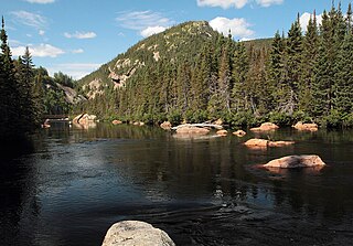
Jacques-Cartier National Park is a provincial park located 50 kilometres (31 mi) north of Quebec City. The park aims to protect wildlife in the Laurentian massif. It lies within the Eastern forest-boreal transition ecoregion.

Duhamel is a town and municipality in the Outaouais region of Quebec, Canada. It is the largest municipality in surface area in the Papineau Regional County Municipality.

Grands-Jardins National Park is a provincial park, located in the Unorganized Territory of Lac-Pikauba, in the Charlevoix Regional County Municipality, an administrative region of Capitale-Nationale, in Quebec, Canada.

The eastern forest–boreal transition is a temperate broadleaf and mixed forests ecoregion of North America, mostly in eastern Canada. It is a transitional zone or region between the predominantly coniferous Boreal Forest and the mostly deciduous broadleaf forest region further south.
Réserve faunique des Laurentides, also known by its former name of parc des Laurentides, is a wildlife reserve in Quebec, Canada, located between Quebec City and the Saguenay–Lac-Saint-Jean region. This reserve is part of the network of wildlife reserves of Quebec (Canada) managed by the Ministry of Energy and Natural Resources (Quebec) and the Société des établissements de plein air du Québec. It is located halfway between Saguenay and Quebec.
The Saint-Maurice Wildlife Reserve is a 782-square-kilometre (302 sq mi) wildlife reserve to the north of Shawinigan, Quebec. The reserve is located west of the Saint-Maurice River in the territory of the Mekinac Regional County Municipality. Like all wildlife reserves, this area is dedicated to the conservation, development and use of wildlife as well as the practice of recreational activity. It is not, however, considered a protected area; forest and mining activities are allowed.

The Mastigouche Wildlife Reserve is a Quebec Wildlife Reserve located in the administrative regions of the Mauricie and Lanaudière, Quebec, in Canada. Comprising 1556 square kilometres, it includes 417 lakes and 13 rivers. Like all wildlife reserves, this area is dedicated to the conservation, development and use of wildlife as well as recreational activities. It is however not considered a protected area, because forest and mining activities are being allowed. The reserve is managed by Sépaq which offers camping and equipment rentals.

The Ashuapmushuan Wildlife Reserve is a wildlife reserve in Quebec, Canada, in the watershed of the Ashuapmushuan River. It is mainly located in the region of Saguenay-Lac-Saint-Jean, between the municipality of La Doré and the city of Chibougamau, and covers an area of 4,488 square kilometres (1,733 sq mi).
The Rouge-Matawin Wildlife Reserve is a Quebec Wildlife Reserve located to the north of Mont-Tremblant National Park, in Quebec, Canada.
The Port-Cartier-Sept-Îles Wildlife Reserve is a wildlife reserve in the province of Quebec, Canada.

Lake Arthur is a lake in Quebec, in Port-Cartier–Sept-Îles Wildlife Reserve in the Côte-Nord region.
The Northeast Toulnustouc River is a tributary of the Toulnustouc River in Lac-Walker, Sept-Rivières, Côte-Nord, Quebec, Canada. The Cartier Railway runs beside it for most of its length.

The Réserve faunique des Chic-Chocs is a wildlife reserve of Quebec located in east of Parc national de la Gaspésie, in the administrative region of Gaspésie–Îles-de-la-Madeleine, in Quebec, Canada.
