The Gulf of St. Lawrence fringes the shores of the provinces of Quebec, New Brunswick, Nova Scotia, Prince Edward Island, Newfoundland and Labrador, in Canada, plus the islands Saint-Pierre and Miquelon, possessions of France, in North America.
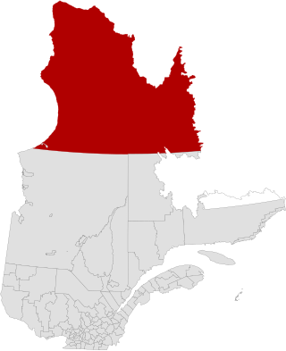
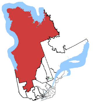
Nunavik is an area in Canada which comprises the northern third of the province of Quebec, part of the Nord-du-Québec region and nearly coterminous with Kativik. Covering a land area of 443,684.71 km2 (171,307.62 sq mi) north of the 55th parallel, it is the homeland of the Inuit of Quebec and part of the wider Inuit Nunangat. Almost all of the 14,045 inhabitants of the region, of whom 90% are Inuit, live in fourteen northern villages on the coast of Nunavik and in the Cree reserved land (TC) of Whapmagoostui, near the northern village of Kuujjuarapik.

Kangiqsualujjuaq is an Inuit village located at the mouth of the George River on the east coast of Ungava Bay in Nunavik, Quebec, Canada. Its population was 956 as of the 2021 census.

Nord-du-Québec is the largest, but the least populous, of the seventeen administrative regions of Quebec, Canada.

Central Canada is a Canadian region consisting of Ontario and Quebec, the largest and most populous provinces of the country. Geographically, they are not at the centre of Canada but instead overlap with Eastern Canada toward the east. Because of their large populations, Ontario and Quebec have traditionally held a significant amount of political power in Canada, leading to some amount of resentment from other regions of the country. Before Confederation, the term "Canada" specifically referred to Central Canada. Today, the term "Central Canada" is less often used than the names of the individual provinces.

Jamésie is a territory equivalent to a regional county municipality (TE) of Nord-du-Québec, Canada.

The Kativik Regional Government is the representative regional authority for most of the Nunavik region of Quebec. Nunavik is the northern half of the Nord-du-Québec administrative region and includes all the territory north of the 55th parallel. The administrative capital is Kuujjuaq, on the Koksoak River, about 50 kilometres inland from the southern end of the Ungava Bay.

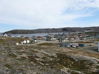
Kuujjuaq, formerly known as Suoivauqaj (ᓲᐃᕙᐅᖃᔾ) and by other names, is a former Hudson's Bay Company outpost at the mouth of the Koksoak River on Ungava Bay that has become the largest northern village in the Nunavik region of Quebec, Canada. It is the administrative capital of the Kativik Regional Government. Its population was 2,668 as of the 2021 census.

Northern Manitoba is a geographic and cultural region of the Canadian province of Manitoba. Originally encompassing a small square around the Red River Colony, the province was extended north to the 60th parallel in 1912. The region's specific boundaries vary, as "northern" communities are considered to share certain social and geographic characteristics, regardless of latitude.
Abitibi—Baie-James—Nunavik—Eeyou is a federal riding in the province of Quebec, Canada, that has been represented in the House of Commons of Canada since 1968. Since the 2019 federal election, its Member of Parliament (MP) has been Sylvie Bérubé of the Bloc Québécois (BQ).
The James Bay and Northern Quebec Agreement is an Aboriginal land claim settlement, approved in 1975 by the Cree and Inuit of northern Quebec, and later slightly modified in 1978 by the Northeastern Quebec Agreement, through which Quebec's Naskapi First Nation joined the agreement. The agreement covers economic development and property issues in northern Quebec, as well as establishing a number of cultural, social and governmental institutions for Indigenous people who are members of the communities involved in the agreement.

Carrot River is a town located in east-central Saskatchewan in Canada. The administration office for the Rural Municipality of Moose Range No. 486 is located in Carrot River.
Ivujivik is a northern village in Nunavik, Quebec, and the northernmost settlement in any Canadian province, although there are settlements further north in the territories. Its population in the 2021 Canadian census was 412.

The Province of Quebec is divided into entities that deliver local government, along with other types of functional divisions.

Tasiujaq is a northern village in Nunavik, in northern Quebec, Canada. Its population in the Canada 2021 Census was 420.
The Clearwater River is a river flowing on the east shore of Lake Guillaume-Delisle, which empties into the Hudson Bay. The "Clearwater River" is located in Nunavik, in the west of the Labrador peninsula, in the administrative region of Nord-du-Québec, in Quebec, in Canada. This river drains Clearwater Lake into Lac Guillaume-Delisle.

St. Lawrence River Estuary stretches from west to east for 655 km, from the outlet of Lake Saint Pierre to Pointe-des-Monts, where it becomes the Gulf of St. Lawrence, in Quebec, Canada.
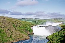
The national parks of Quebec are provincial parks created by the government of Quebec to protect territories representative of natural regions of the province or sites of exceptional character, while making them accessible to the public for education and/or recreation. As of 2023, there are 28 such parks in Quebec, which protect an area of 42,765.57 kilometres (26,573.29 mi), or about 2.8% of the territory of the province. All but four parks are administered by the Société des établissements de plein air du Québec (Sépaq). Those four are administered by Nunavik Parks. In addition, Sépaq jointly administers a National Marine Conservation Area with Parks Canada as part of the country's national park system.