| Park | Location | Area
(km2) |
|---|
| Aigle-à-Tête-Blanche Ecological Reserve | Rapides-des-Joachims | 2.67 |
| André-Linteau Ecological Reserve | Rapides-des-Joachims | 0.91 |
| André-Michaux Ecological Reserve | Denholm | 4.50 |
| Bog-à-Lanières Ecological Reserve | Lac-Édouard | 4.30 |
| Boisé-des-Muir Ecological Reserve | Hinchinbrooke | 0.12 |
| Caribous-de-Jourdan Ecological Reserve | Val-d'Or | 7.12 |
| Caribous-de-Val-d’Or Biodiversity Reserve | La Vallée-de-l'Or | 434.2 |
| Charles-B.-Banville Ecological Reserve | Lac-Huron | 10.00 |
| Chênaie-des-Îles-Finlay Ecological Reserve | Waltham | 0.94 |
| Chicobi Ecological Reserve | Lac-Chicobi | 21.23 |
| Claude-Mélançon Ecological Reserve | Saint-Philémon | 5.35 |
| Couchepaganiche Ecological Reserve | Métabetchouan–Lac-à-la-Croix | 0.39 |
| Dunes-de-Berry Ecological Reserve | Berry | 2.59 |
| Dunes-de-la-Moraine-d'Harricana Ecological Reserve | Rouyn-Noranda | 5.40 |
| Érablière-du-Trente-et-Un-Milles Ecological Reserve | Gracefield | 6.06 |
| Ernest-Lepage Ecological Reserve | Rivière-Bonaventure | 8.10 |
| Estuaire-de-la-Rivière-Bonaventure Aquatic Reserve | Bonaventure | 1.8 |
| Fernald Ecological Reserve | Rivière-Bonjour | 7.35 |
| Forêt-la-Blanche Ecological Reserve | Mayo | 20.52 |
| G.-Oscar-Villeneuve Ecological Reserve | Mont-Valin | 5.67 |
| Grande-Rivière Ecological Reserve | Mont-Alexandre | 173.00 |
| Grand-Lac-Salé Ecological Reserve | L'Île-d'Anticosti | 23.39 |
| Grands-Ormes Ecological Reserve | Mont-Élie | 9.20 |
| Île-Brion Ecological Reserve | Grosse-Île | 6.50 |
| Île-Garth Ecological Reserve | Bois-des-Filion | 0.17 |
| Îles-Avelle-Wight-et-Hiam Ecological Reserve | Vaudreuil-Dorion | 0.90 |
| Irénée-Marie Ecological Reserve | Rivière-de-la-Savane | 1.89 |
| Irène-Fournier Ecological Reserve | Rivière-Bonjour | 4.40 |
| Jackrabbit Ecological Reserve | Montcalm | 7.50 |
| James-Little Ecological Reserve | Sheenboro | 2.04 |
| J.-Clovis-Laflamme Ecological Reserve | Lac-Ashuapmushuan | 10.15 |
| Judith-De Brésoles Ecological Reserve | Lac-Édouard | 10.90 |
| Jules-Carpentier Ecological Reserve | Pont-Rouge | 0.05 |
| Karst-de-Saint-Elzéar Biodiversity Reserve | Bonaventure | 44.27 |
| Kettles-de-Berry Ecological Reserve | Berry | 2.67 |
| Lac-à-la-Tortue Ecological Reserve | Shawinigan | 5.66 |
| Lac-Malakisis Ecological Reserve | Les Lacs-du-Témiscamingue | 30.27 |
| Lacs-Vaudray-et-Joannès Biodiversity Reserve | Rouyn-Noranda | 193.07 |
| Léon-Provancher Ecological Reserve | Bécancour | 4.84 |
| Lionel-Cinq-Mars Ecological Reserve | Saint-Édouard-de-Lotbinière | 4.40 |
| Louis-Babel Ecological Reserve | Rivière-aux-Outardes | 235.40 |
| Louis-Ovide-Brunet Ecological Reserve | Lac-Bouchette | 6.69 |
| Louis-Zéphirin-Rousseau Ecological Reserve | Notre-Dame-de-Pontmain | 0.05 |
| Manche-d'Épée Ecological Reserve | Sainte-Madeleine-de-la-Rivière-Madeleine | 5.73 |
| Marcel-Léger Ecological Reserve | Trois-Rivières | 0.36 |
| Marcelle-Gauvreau Ecological Reserve | Mont-Valin | 1.14 |
| Marcel-Raymond Ecological Reserve | Henryville | 0.64 |
| Marie-Jean-Eudes Ecological Reserve | Saint-Alexis-des-Monts | 8.45 |
| Matamec Ecological Reserve | Sept-Îles | 186.00 |
| Météorite Biodiversity Reserve | Manicouagan | 233.00 |
| Micocoulier Ecological Reserve | Coteau-du-Lac | 0.29 |
| Mine-aux-Pipistrelles Ecological Reserve | Potton | 0.03 |
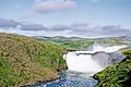
| Montmorency Falls | between Beauport, and Boischatel | |
| Mont-Saint-Pierre Ecological Reserve | Mont-Saint-Pierre | 6.43 |
| Père-Louis-Marie Ecological Reserve | Bouchette | 3.15 |
| Pin-Rigide Ecological Reserve | Franklin | 0.66 |
| Pointe-Heath Ecological Reserve | L'Île-d'Anticosti | 18.69 |
| Pointe-Platon Ecological Reserve | Sainte-Croix | 0.59 |
| Presqu'île-Robillard Ecological Reserve | Saint-André-d'Argenteuil | 0.84 |
| Ristigouche Ecological Reserve | Ristigouche-Sud-Est | 4.68 |
| Rivière-aux-Brochets Ecological Reserve | Saint-Armand | 1.26 |
| Rivière-du-Moulin Ecological Reserve | Lotbinière | 0.11 |
| Rivière-Rouge Ecological Reserve | Grenville-sur-la-Rouge | 3.13 |
| Rolland-Germain Ecological Reserve | Montcerf-Lytton | 13.70 |
| Ruisseau-de-l'Indien Ecological Reserve | Sheenboro | 3.24 |
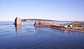
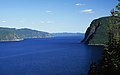
| Saguenay–St. Lawrence Marine Park | Rivière-Éternité | 1138.00 |
| Samuel-Brisson Ecological Reserve | Hampden | 7.90 |
| Serpentine-de-Coleraine Ecological Reserve | Saint-Joseph-de-Coleraine | 3.97 |
| Tantaré Ecological Reserve | Saint-Gabriel-de-Valcartier | 14.50 |
| Tapani Ecological Reserve | Sainte-Anne-du-Lac | 0.17 |
| Thomas-Fortin Ecological Reserve | Lac-Pikauba | 1.18 |
| Thomas-Sterry-Hunt International Ecological Reserve | Saint-Just-de-Bretenières | 0.56 |
| Tourbières-de-Lanoraie Ecological Reserve | Lanoraie | 4.15 |
| Uapishka Biodiversity Reserve | Manicouagan | 1,382.00 |
| Vallée-du-Ruiter Ecological Reserve | Potton | 1.17 |
| Victor-A.-Huard Ecological Reserve | Lac-Ministuk | 0.20 |
| Vieux-Arbres Ecological Reserve | Duparquet | 0.04 |
| William-Baldwin Ecological Reserve | Berry | 291.38 |
|