Contents
- National parks
- Territorial parks
- Kitikmeot Region
- Kivalliq Region
- Qikiqtaaluk Region
- Migratory bird sanctuaries
- Other
- References
- External links
| Part of a series on |
| Canadian wildlife |
|---|
 |

This is a list of protected areas of Nunavut .
| Part of a series on |
| Canadian wildlife |
|---|
| |
This is a list of protected areas of Nunavut .
| Name | Access point / community | Area | Coordinates | Image |
|---|---|---|---|---|
| Auyuittuq National Park [1] | Pangnirtung / Qikiqtarjuaq [2] | 19,080 km2 (7,370 sq mi) [3] | 67°30′N066°00′W / 67.500°N 66.000°W [4] | 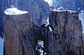 |
| Qausuittuq National Park [5] | Resolute [6] | 11,000 km2 (4,200 sq mi) [7] | 72°07′27″N100°01′52″W / 72.12417°N 100.03111°W [8] | 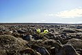 |
| Quttinirpaaq National Park [9] | Resolute [10] | 37,775 km2 (14,585 sq mi) [11] | 82°13′N72°13′W / 82.217°N 72.217°W [12] | 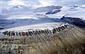 |
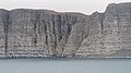
| Sirmilik National Park [13] | Arctic Bay / Pond Inlet [14] | 22,200 km2 (8,600 sq mi) [15] | 72°50′N080°35′W / 72.833°N 80.583°W [16] |  |
| Ukkusiksalik National Park [17] | Baker Lake / Chesterfield Inlet / Coral Harbour / Naujaat / Rankin Inlet [18] | 23,088 km2 (8,914 sq mi) [19] | 65°29′55″N88°53′43″W / 65.49861°N 88.89528°W [20] |  |
| Name | Community | Commons category | Picture | Coordinates |
|---|---|---|---|---|
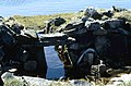
| Kugluk/Bloody Falls Territorial Park [21] | Kugluktuk [22] | Kugluk/Bloody Falls Territorial Park |  | 67°44′N115°22′W / 67.733°N 115.367°W |
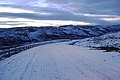
| Ovayok Territorial Park [23] | Cambridge Bay [23] | Ovayok Territorial Park |  | 69°10′N104°43′W / 69.167°N 104.717°W |
| Name | Community | Commons category | Picture | Coordinates |
|---|---|---|---|---|
| Inuujaarvik Territorial Park [24] | Baker Lake [24] | 64°19′N96°05′W / 64.317°N 96.083°W | ||
| Iqalugaarjuup Nunanga Territorial Park [25] | Rankin Inlet [25] | 62°53′N92°10′W / 62.883°N 92.167°W |