Yukon is the smallest and westernmost of Canada's three territories. It also is the second-least populated province or territory in Canada, with a population of 43,964 as of March 2022. Whitehorse, the territorial capital, is the largest settlement in any of the three territories.

Fathom Five National Marine Park is a National Marine Conservation Area in the Georgian Bay part of Lake Huron, Ontario, Canada, that seeks to protect and display shipwrecks and lighthouses, and conserve freshwater ecosystems. Parks Canada has management plans for the aquatic and terrestrial ecosystems, with a multi-action plan for species that are at risk, including endemic species, the Monarch butterfly, the eastern ribbonsnake, and the eastern whip-poor-will. The aquatic ecosystems in the park are also of particular interest. Many fish, shellfish, amphibians, and eels are an attraction for naturalists in the park. Much of this wildlife is accessible to scuba divers and snorkellers in the park. The many shipwrecks make the park a popular scuba diving destination, and glass bottom boat tours leave Tobermory regularly, allowing tourists to see the shipwrecks without having to get wet. Additionally, there are three main popular hiking trails found within Fathom Five National Marine Park that provides visitors with views of old growth forests and the Georgian Bay. The Saugeen Ojibway Peoples have inhabited the Bruce Peninsula and the area that is now Fathom Five National Marine Park for thousands of years. This land provided for their communities and their people with the plethora of wildlife and plant life. They provide the local knowledge about Lake Huron and its ecological value to the reserve, park, and their overall livelihood. Parks Canada and Saugeen Ojibway People's collaboration is said to yield a benefit to both parties with regard to overall ecosystem knowledge.

Kluane National Park and Reserve are two protected areas in the southwest corner of the territory of Yukon. The National Park Reserve was set aside in 1972 to become a national park, pending settlement of First Nations land claims. It covered an area of 22,013 square kilometres. When agreement was reached with the Champagne and Aishihik First Nations over an eastern portion of the Reserve, that part—about 5,900 square kilometres —became a national park in 1993, and is a unit of the national park system administered co-operatively with Parks Canada. The larger western section remains a Reserve, awaiting a final land claim settlement with the Kluane First Nation. The park borders British Columbia to the south, while the Reserve borders both British Columbia to the south, and the United States (Alaska) to the south and west.

The Peace–Athabasca Delta, located in northeast Alberta, is the largest freshwater inland river delta in North America. It is located partially within the southeast corner of Wood Buffalo National Park, Canada's largest national park, and also spreads into the Regional Municipality of Wood Buffalo, west and south of the historical community of Fort Chipewyan. The delta encompasses approximately 321,200 ha, formed where the Peace and Athabasca rivers converge on the Slave River and Lake Athabasca. The delta region is designated a wetland of international importance and a UNESCO World Heritage Site. The region is large enough that it is considered one of twenty distinct natural subregions of Alberta by the provincial government's Natural Regions Committee.
The Canadian Wildlife Service or CWS, is a Branch of the Department of the Environment, a department of the Government of Canada. November 1, 2012 marked the 65th anniversary of the founding of Service.

Protected areas of New Zealand are areas that are in some way protected to preserve their environmental, scientific, scenic, historical, cultural or recreational value. There are about 10,000 protected areas covering about a third of the country. The method and aims of protection vary according to the importance of the resource and whether it is publicly or privately owned.

Protected areas of Canada consist of approximately 12.1 percent of the nation's landmass and freshwater are considered conservation areas, including 11.4 percent designated as protected areas. Approximately 13.8 percent of Canada's territorial waters are conserved, including 8.9 percent designated as protected areas. Terrestrial areas conserved have increased by 65 percent in the 21st century, while marine areas conserved have increased by more than 3,800 percent.
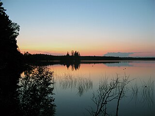
Lakeland Provincial Park and Lakeland Provincial Recreation Area are located east of Lac La Biche, Alberta, Canada, in Lac La Biche County.

The history of post-confederation Canada began on July 1, 1867, when the British North American colonies of Canada, New Brunswick, and Nova Scotia were united to form a single Dominion within the British Empire. Upon Confederation, the United Province of Canada was immediately split into the provinces of Ontario and Quebec. The colonies of Prince Edward Island and British Columbia joined shortly after, and Canada acquired the vast expanse of the continent controlled by the Hudson's Bay Company, which was eventually divided into new territories and provinces. Canada evolved into a fully sovereign state by 1982.

The Northwest Territories is a territory in Northern Canada, specifically in Northwestern Canada between Yukon Territory and Nunavut including part of Victoria Island, Melville Island, and other islands on the western Arctic Archipelago. Originally a much wider territory enclosing most of central and northern Canada, the Northwest Territories was created in 1870 from the Hudson's Bay Company's holdings that were sold to Canada from 1869-1870. In addition, Alberta and Saskatchewan were formed from the territory in 1905. In 1999, it was divided again: the eastern portion became the new territory of Nunavut. Yellowknife stands as its largest city and capital. It has a population of 42,800 and has an area of 532,643 sq mi (1,379,540 km2). The current territory lies west of Nunavut, north of latitude 60° north, and east of Yukon.

Old Crow Flats is a 6,170 km2 (2,382 sq mi) wetland complex in northern Yukon, Canada along the Old Crow River. It is north of the Arctic Circle and south of the Beaufort Sea, and is nearly surrounded by mountains.

Polar Bear Pass National Wildlife Area is a National Wildlife Area on Bathurst Island within Qikiqtaaluk, Nunavut, Canada. It is on federal Crown land, and is administered by the Canadian Wildlife Service, a division of Environment Canada, with respect to the Canada Wildlife Act's National Wildlife Area Regulations. Land use is also subject to the Nunavut Land Claims Agreement. To the north and west is Qausuittuq National Park.
The wildlife of Canada or biodiversity of Canada consist of over 80,000 classified species, with an equal number thought yet to be recognized. Known fauna and flora have been identified from five different kingdoms: protozoa ; chromist ; fungis ; plants ; and animals. Insects account for nearly 70 percent of recorded animal species in Canada.

Wetland conservation is aimed at protecting and preserving areas where water exists at or near the Earth's surface, such as swamps, marshes and bogs. Wetlands cover at least six per cent of the Earth and have become a focal issue for conservation due to the ecosystem services they provide. More than three billion people, around half the world’s population, obtain their basic water needs from inland freshwater wetlands. The same number of people rely on rice as their staple food, a crop grown largely in natural and artificial wetlands. In some parts of the world, such as the Kilombero wetland in Tanzania, almost the entire local population relies on wetland cultivation for their livelihoods.

The Peel watershed drains 14% of the Yukon Territory Canada and flows into the Beaufort Sea via the Peel and then Mackenzie Rivers. While the lower part of the Peel River and its confluence with the Mackenzie River are in the North West Territories, most of the watershed, 68,000 km2 out of 77,000 km2 is in the Yukon. Six major tributaries and numerous smaller streams feed the Peel. The Yukon portion of the watershed is undergoing land use planning, a process laid out in Chapter 11 of the Yukon Land Claims Agreement and is called the Peel Watershed Planning Region (PWPR). This article is confined to the PWPR.
Located in the southern part of British Columbia, Columbia National Wildlife Area was established to protect its wetlands and as a temporary home for migratory birds travelling to South America. The National Wildlife Area (NWA) is divided into four unit areas: Wilmer, Spillimacheen, Brisco and Harrogate, which are home to many diverse species of animals and plants which are significant in Canada.

The Indigenous peoples of Yukon are ethnic groups who, prior to European contact, occupied the former countries now collectively known as Yukon. While most First Nations in the Canadian territory are a part of the wider Dene Nation, there are Tlingit and Métis nations that blend into the wider spectrum of indigeneity across Canada. Traditionally hunter-gatherers, indigenous peoples and their associated nations retain close connections to the land, the rivers and the seasons of their respective countries or homelands. Their histories are recorded and passed down the generations through oral traditions. European contact and invasion brought many changes to the native cultures of Yukon including land loss and non-traditional governance and education. However, indigenous people in Yukon continue to foster their connections with the land in seasonal wage labour such as fishing and trapping. Today, indigenous groups aim to maintain and develop indigenous languages, traditional or culturally-appropriate forms of education, cultures, spiritualities and indigenous rights.
Sturgeon Bay Provincial Park is a provincial park on the western shore of Lake Winnipeg in Manitoba, Canada. The park is considered to be a Class Ib protected area under the IUCN protected area management categories. It is 144.9 km2 (55.9 sq mi) in size.