| Part of a series on |
| Canadian wildlife |
|---|
 |

This is a list of protected areas of the Northwest Territories .
| Part of a series on |
| Canadian wildlife |
|---|
| |
This is a list of protected areas of the Northwest Territories .

| Provinces | |
|---|---|
| Territories | |

The Niagara River flows north from Lake Erie to Lake Ontario, forming part of the border between Ontario, Canada, to the west, and New York, United States, to the east. The origin of the river's name is debated. Iroquoian scholar Bruce Trigger suggests it is derived from a branch of the local Neutral Confederacy, referred to as the Niagagarega people on several late-17th-century French maps. George R. Stewart posits that it comes from an Iroquois town named Ongniaahra, meaning "point of land cut in two."
The Metabetchouan River is a tributary of Lac Saint-Jean in the centre of the province of Quebec, Canada. The course of this river successively crosses the regional county municipalities (MRC) of:

The Cossatot River is an 89-mile-long (143 km) river in Howard, Polk and Sevier counties in the U.S. state of Arkansas.

Chipewyan or Dënesųłinë́, often simply called Dëne, is the language spoken by the Chipewyan people of northwestern Canada. It is categorized as part of the Northern Athabaskan language family. It has nearly 12,000 speakers in Canada, mostly in Saskatchewan, Alberta, Manitoba and the Northwest Territories. It has official status only in the Northwest Territories, alongside eight other aboriginal languages: Cree, Tlicho, Gwich'in, Inuktitut, Inuinnaqtun, Inuvialuktun, North Slavey and South Slavey.
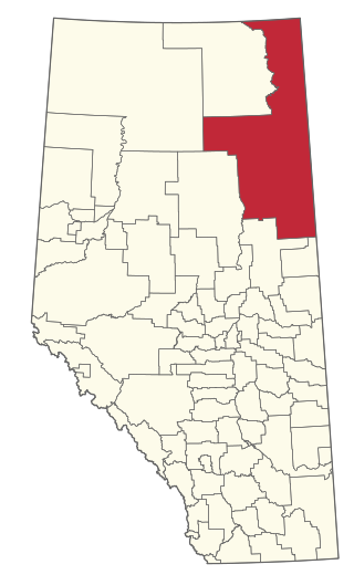
The Regional Municipality of Wood Buffalo is a specialized municipality in northeast Alberta, Canada. It is the largest regional municipality in Canada by area and is home to oil sand deposits known as the Athabasca oil sands.

The South Nahanni River is a major tributary of the Liard River, located roughly 500 km (310 mi) west of Yellowknife in the Northwest Territories of Canada. It is the centerpiece of Nahanni National Park Reserve. It flows from the Mackenzie Mountains in the west, through the Selwyn Mountains, growing as it heads east over the majestic Virginia Falls, and finally empties into the Liard River. The Nahanni has a unique geological history. It was formed when the area was a broad flat plain, forming a winding course typical of flatland rivers. As the mountains lifted, the river cut four deep canyons into the rock, maintaining its eccentric course.

The Boreal Plains Ecozone, as defined by the Commission for Environmental Cooperation (CEC), is a terrestrial ecozone in the western Canadian provinces of Manitoba, Saskatchewan and Alberta. It also has minor extensions into northeastern British Columbia and south-central Northwest Territories. The region extends over 779,471 km2, of which 58,981 km2 is conserved.

Hornaday River is a waterway located above the Arctic Circle on the mainland of Northern Canada.
The Kedgwick River is a tributary of the head of the Restigouche River, in New Brunswick, in Canada. It flows southeast in:

Pike River is a tributary of Lake Champlain, flowing successively in:
The Tawachiche West River is in the Municipality of Lac-aux-Sables. Its mouth is 9.5 kilometres (5.9 mi) north of the village of Hervey-Jonction), in the administrative region of Mauricie, in the province of Quebec, Canada. Flowing mostly in the Marmier (township), its watershed is part of the Batiscanie, in the area of the MRC Mékinac. The river flows from north-west to south-east to empty into the Tawachiche River. Tawachiche West River is entirely in forest areas. The surface of the river is usually frozen from November to April. Annually, the river flow is high during the spring thaw.

Salt River is a river in Canada whose source is McNeil Lake in Wood Buffalo National Park in northern Alberta. It enters the Slave River north of Fort Smith, Northwest Territories.
The Touladi River flows in the administrative region of Bas-Saint-Laurent, south of the Gaspé Peninsula, in Quebec, Canada. This river runs through the regional county municipality (RCM) of:
Nicabau Lake is a freshwater body of the unorganized territory of Lac-Ashuapmushuan, Quebec, in the western part of Regional County Municipality (MRC) Le Domaine-du-Roy, in the Saguenay-Lac-Saint-Jean administrative region, in the province of Quebec, in Canada.

Boisvert River is a tributary of the north shore of Ashuapmushuan Lake, flowing into the unorganized territory of Lac-Ashuapmushuan, Quebec, into the Regional County Municipality (RCM) of Le Domaine-du-Roy, in the administrative region of Saguenay-Lac-Saint-Jean, in Quebec, in Canada.
The Aigremont Lake is a freshwater body flowing out of the Little Chief River, flowing into the unorganized territory of Lac-Ashuapmushuan, Quebec, in the northwestern part of the Regional County Municipality (RCM) Le Domaine-du-Roy, in the Saguenay-Lac-Saint-Jean administrative region, in the province of Quebec, in Canada.