Fort Reliance, Northwest Territories

Last updated

Fort Reliance, Northwest Territories
Great Slave Lake, Northwest Territories, Canada.
Typewinter camp; trading post
Site information
Controlled by Hudson's Bay Company
Official nameFort Reliance National Historic Site of Canada
Designated1953
Site history
Built1833
Materialslogs

Fort Reliance is the site of a Hudson's Bay Company fort located on the east arm of Great Slave Lake, Northwest Territories, Canada.

Contents

History

Fort Reliance was originally built in 1833 by George Back during the Arctic Land Expedition to the Arctic Ocean via the Back River. The expedition, partly scientific and partly searching for the missing John Ross, used Fort Reliance as a winter camp. [1]

Back's fort was made up of a main house with several smaller ones that were constructed from logs. The houses had stone and clay chimneys for heating. The outline of the logs along with the chimneys and some storage pits still exist. [1]

In 1855, the Hudson's Bay Company's Chief Factor James Anderson, for whom the Anderson River is named, rebuilt the fort. It was intended to be used as winter quarters while searching for the lost expedition of John Franklin, but it was again abandoned after one season. [2]

It was not a fur trading outpost although the site was later used by trappers in the Thelon River area. In 1897, a log cabin, using one of the chimneys, was built by an American trapper, Buffalo Jones. [3]

Fort Reliance was designated a National Historic Site in 1953. [4] It is described by Parks Canada as the "oldest continuously operating Hudson's Bay Company post, 1833". Together with the Prince of Wales Northern Heritage Centre, Parks Canada is working to preserve and protect the site, which has resulted in the chimneys being rehabilitated. [1] [5] In 2010, the same property was designated “Old Fort Reliance Territorial Historic Site."

The site lies within Thaidene Nene National Park Reserve. If that proposed national park is ever realized, Fort Reliance National Historic Site would also join the national park system as a separate unit.

Climate

Climate data for Fort Reliance
MonthJanFebMarAprMayJunJulAugSepOctNovDecYear
Record high °C (°F)2.1
(35.8)
6.1
(43.0)
8.6
(47.5)
16.1
(61.0)
26.1
(79.0)
29.4
(84.9)
34.3
(93.7)
30.0
(86.0)
27.2
(81.0)
17.9
(64.2)
6.7
(44.1)
4.1
(39.4)
34.3
(93.7)
Average high °C (°F)−23.5
(−10.3)
−21.0
(−5.8)
−14.9
(5.2)
−2.5
(27.5)
7.9
(46.2)
15.6
(60.1)
19.2
(66.6)
16.8
(62.2)
9.6
(49.3)
0.8
(33.4)
−10.9
(12.4)
−20.4
(−4.7)
−2.0
(28.4)
Daily mean °C (°F)−28.1
(−18.6)
−26.1
(−15.0)
−21.0
(−5.8)
−8.6
(16.5)
2.5
(36.5)
9.9
(49.8)
14.3
(57.7)
12.9
(55.2)
6.5
(43.7)
−2.0
(28.4)
−14.6
(5.7)
−24.4
(−11.9)
−6.6
(20.1)
Average low °C (°F)−32.7
(−26.9)
−31.1
(−24.0)
−27.0
(−16.6)
−14.6
(5.7)
−2.9
(26.8)
4.2
(39.6)
9.3
(48.7)
8.9
(48.0)
3.4
(38.1)
−4.8
(23.4)
−18.2
(−0.8)
−28.4
(−19.1)
−11.2
(11.8)
Record low °C (°F)−53.5
(−64.3)
−51.2
(−60.2)
−50.0
(−58.0)
−41.1
(−42.0)
−31.1
(−24.0)
−7.2
(19.0)
−1.1
(30.0)
0.0
(32.0)
−7.8
(18.0)
−23.3
(−9.9)
−43.3
(−45.9)
−45.7
(−50.3)
−53.5
(−64.3)
Average precipitation mm (inches)11.0
(0.43)
9.9
(0.39)
9.6
(0.38)
14.5
(0.57)
19.2
(0.76)
30.5
(1.20)
33.2
(1.31)
50.0
(1.97)
32.2
(1.27)
28.5
(1.12)
19.7
(0.78)
13.7
(0.54)
271.9
(10.70)
Source: Environment Canada [6]

Demographics

Federal census population history of Reliance
YearPop.±%
19769    
198115+66.7%
198611−26.7%
1991 10−9.1%
1996 2−80.0%
2001 0−100.0%
2006 10    
2011 5−50.0%
2016 0−100.0%
2021 00.00%
Source: Statistics Canada
[7] [8] [9] [10] [11] [12] [13] [14] [15]

In the 2021 Census of Population conducted by Statistics Canada, Reliance had a population of 0 living in 0 of its 1 total private dwellings, no change from its 2016 population of 0. With a land area of 21 km2 (8.1 sq mi), it had a population density of

Related Research Articles

<span class="mw-page-title-main">Annapolis County, Nova Scotia</span> County in Nova Scotia, Canada

Annapolis County is a county in the Canadian province of Nova Scotia located in the western part of the province located on the Bay of Fundy. The county seat is Annapolis Royal.

<span class="mw-page-title-main">Tulita</span> Hamlet in Northwest Territories, Canada

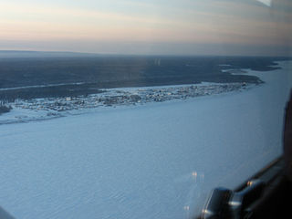
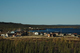
Tulita, which in Slavey means "where the rivers or waters meet," is a hamlet in the Sahtu Region of the Northwest Territories, Canada. It was formerly known as Fort Norman, until 1 January 1996. It is located at the junction of the Great Bear River and the Mackenzie River; the Bear originates at Great Bear Lake adjacent to Deline.

<span class="mw-page-title-main">Fort Simpson</span> Village in Northwest Territories, Canada

Fort Simpson is a village, the only one in the entire territory, in the Dehcho Region of the Northwest Territories, Canada. The community is located on an island at the confluence of the Mackenzie and Liard rivers. It is approximately 500 km (310 mi) west of Yellowknife. Both rivers were traditionally trade routes for the Hudson's Bay Company and the native Dene people of the area.

<span class="mw-page-title-main">Tsiigehtchic</span> Charter Community in Northwest Territories, Canada

Tsiigehtchic, officially the Charter Community of Tsiigehtchic, is a Gwich'in community located at the confluence of the Mackenzie and the Arctic Red Rivers, in the Inuvik Region of the Northwest Territories, Canada. The community was formerly known as Arctic Red River, until 1 April 1994. The Gwichya Gwich'in First Nation is located in Tsiigehtchic.

<span class="mw-page-title-main">Gjoa Haven</span> Hamlet in Nunavut, Canada

Gjoa Haven is an Inuit hamlet in Nunavut, above the Arctic Circle, located in the Kitikmeot Region, 1,056 km (656 mi) northeast of Yellowknife, Northwest Territories. It is the only settlement on King William Island.

<span class="mw-page-title-main">Fort Resolution</span> Hamlet in Northwest Territories, Canada

Fort Resolution is a hamlet in the South Slave Region of the Northwest Territories, Canada. The community is situated at the mouth of the Slave River, on the shores of Great Slave Lake, and at the end of the Fort Resolution Highway. It is the headquarters of the Deninu Kųę́ First Nation, whose Chief is Louis Balsillie.

<span class="mw-page-title-main">Fort Providence</span> Hamlet in Northwest Territories, Canada

Fort Providence is a hamlet in the South Slave Region of the Northwest Territories, Canada. Located west of Great Slave Lake, it has all-weather road connections by way of the Yellowknife Highway branch off the Mackenzie Highway, and the Deh Cho Bridge opened November 30, 2012, near Fort Providence over the Mackenzie. The bridge replaced the ice bridge and ferry, enabling year-round crossing of the river.

<span class="mw-page-title-main">Norman Wells</span> Town in Northwest Territories, Canada

Norman Wells is a town located in the Sahtu Region, Northwest Territories, Canada. The town, which hosts the Sahtu Regional office, is situated on the north side of the Mackenzie River and provides a view down the valley of the Franklin and Richardson mountains.

<span class="mw-page-title-main">Sachs Harbour</span> Hamlet in Northwest Territories, Canada

Sachs Harbour is a hamlet located in the Inuvik Region of the Northwest Territories, Canada. Situated on the southwestern coast of Banks Island in the Inuvialuit Settlement Region, the population according to the 2021 census count was 104 people. Sachs Harbour is the only permanent settlement on Banks Island.

<span class="mw-page-title-main">Ulukhaktok</span> Hamlet in Northwest Territories, Canada

Ulukhaktok is a small hamlet on the west coast of Victoria Island, in the Inuvik Region of the Northwest Territories, Canada.

<span class="mw-page-title-main">Fort Good Hope</span> Charter Community in Northwest Territories, Canada

Fort Good Hope, is a charter community in the Sahtu Region of the Northwest Territories, Canada. It is located on a peninsula between Jackfish Creek and the east bank of the Mackenzie River, about 145 km (90 mi) northwest of Norman Wells.

<span class="mw-page-title-main">Fort McPherson, Northwest Territories</span> Hamlet in Northwest Territories, Canada

Fort McPherson is a hamlet located in the Inuvik Region of the Northwest Territories, Canada. It is located on the east bank of the Peel River and is 121 km (75 mi) south of Inuvik on the Dempster Highway.

<span class="mw-page-title-main">Kimmirut</span> Hamlet in Nunavut, Canada

Kimmirut is a community in the Qikiqtaaluk Region, Nunavut, Canada. It is located on the shore of Hudson Strait on Baffin Island's Meta Incognita Peninsula. Kimmirut means "heel", and refers to a rocky outcrop in the inlet.

<span class="mw-page-title-main">Umingmaktok</span> Abandoned settlement in Nunavut, Canada

Umingmaktok is a now abandoned settlement located in Bathurst Inlet in the Kitikmeot of the Canadian territory of Nunavut. The community was previously known as Bay Chimo and the Inuit refer to the community as Umingmaktuuq.

<span class="mw-page-title-main">Colville Lake, Northwest Territories</span> Settlement Corporation in Northwest Territories, Canada

Colville Lake is a settlement corporation located in the Sahtu Region of the Northwest Territories, Canada. The community is located 50 km (31 mi) north of the Arctic Circle, on a lake of the same name, and is northeast of Norman Wells. This settlement is the administrative office of the Behdzi Ahda band government. The community is likely named for Hudson's Bay Company Governor Andrew Colvile.

<span class="mw-page-title-main">Fort Liard</span> Hamlet in Northwest Territories, Canada

Fort Liard is a hamlet in the Dehcho Region of the Northwest Territories, Canada. It is located 37 km (23 mi) north of the British Columbia border. It became accessible by road in 1984 with the completion of the Liard Highway.

<span class="mw-page-title-main">Behchokǫ̀</span> Tłı̨chǫ Community Government in Northwest Territories, Canada

Behchokǫ̀, officially the Tłı̨chǫ Community Government of Behchokǫ̀, is a community in the North Slave Region of the Northwest Territories, Canada. Behchokǫ̀ is located on the Yellowknife Highway, on the northwest tip of Great Slave Lake, approximately 110 km (68 mi) northwest of Yellowknife.

Kakisa is a "Designated Authority" in the South Slave Region of the Northwest Territories, Canada. The community is located on Kakisa Lake, and is southeast of Fort Providence. Originally located at Tathlina Lake, the community moved, in 1962, to the present location in order to be closer to the Mackenzie Highway and is linked by a 13 km (8.1 mi) all-weather road.

<span class="mw-page-title-main">Bathurst Inlet, Nunavut</span> Abandoned settlement in Nunavut, Canada

Bathurst Inlet,, is a small Inuit community located in Bathurst Inlet in the Kitikmeot Region of Nunavut, Canada.

<span class="mw-page-title-main">Délı̨nę</span> Charter Community in Northwest Territories, Canada

The Charter Community of Délı̨nę is located in the Sahtu Region of the Northwest Territories, Canada, on the western shore of Great Bear Lake and is 544 km (338 mi) northwest of Yellowknife. Délı̨nę means "where the waters flow", a reference to the headwaters of the Great Bear River, Sahtúdé. It is the only settlement on the shores of Great Bear Lake as Fort Confidence was last used in the 1800s and Port Radium closed in 1982.

References

  1. 1 2 3 Old Fort Reliance Archived 18 December 2008 at the Wayback Machine
  2. James Anderson
  3. Buffalo Jones
  4. Fort Reliance . Canadian Register of Historic Places . Retrieved 8 October 2013.
  5. National Historic Sites of Canada System Plan
  6. Environment CanadaCanadian Climate Normals 1971–2000. Retrieved 17 June 2011.
  7. "1981 Census of Canada: Census subdivisions in decreasing population order" (PDF). Statistics Canada. May 1992. Retrieved 1 February 2021.
  8. "1986 Census: Population – Census Divisions and Census Subdivisions" (PDF). Statistics Canada. September 1987. Retrieved 1 February 2022.
  9. "91 Census: Census Divisions and Census Subdivisions – Population and Dwelling Counts" (PDF). Statistics Canada. April 1992. Retrieved 1 February 2022.
  10. "96 Census: A National Overview – Population and Dwelling Counts" (PDF). Statistics Canada. April 1997. Retrieved 1 February 2022.
  11. "Population and Dwelling Counts, for Canada, Provinces and Territories, and Census Subdivisions (Municipalities), 2001 and 1996 Censuses – 100% Data (Northwest Territories)". Statistics Canada. 15 August 2012. Retrieved 1 February 2022.
  12. "Population and dwelling counts, for Canada, provinces and territories, and census subdivisions (municipalities), 2006 and 2001 censuses – 100% data (Northwest Territories)". Statistics Canada. 20 August 2021. Retrieved 1 February 2022.
  13. "Population and dwelling counts, for Canada, provinces and territories, and census subdivisions (municipalities), 2011 and 2006 censuses (Northwest Territories)". Statistics Canada. 25 July 2021. Retrieved 1 February 2022.
  14. "Population and dwelling counts, for Canada, provinces and territories, and census subdivisions (municipalities), 2016 and 2011 censuses – 100% data (Northwest Territories)". Statistics Canada. 8 February 2017. Retrieved 1 February 2022.
  15. 1 2 "Population and dwelling counts: Canada, provinces and territories, and census subdivisions (municipalities), Northwest Territories". Statistics Canada. 9 February 2022. Retrieved 18 February 2022.

62°42′45″N109°09′53″W / 62.71250°N 109.16472°W / 62.71250; -109.16472 (Fort Reliance, Northwest Territories)