
The whooping crane is an endangered crane species, native to North America, named for its “whooping” calls. Along with the sandhill crane, it is one of only two crane species native to North America, and it is also the tallest North American bird species. The whooping crane's lifespan is estimated to be 22-24 years in the wild. After being pushed to the brink of extinction, due to unregulated hunting and loss of habitat, and just 21 wild cranes remaining by 1941, conservation efforts would lead to a partial recovery. The total number of cranes in the surviving migratory population, plus three reintroduced flocks and in-captivity, only slightly exceeds 800 birds as of 2020.

Wood Buffalo National Park is the largest national park of Canada at 44,741 km2 (17,275 sq mi). It is in northeastern Alberta and the southern Northwest Territories. Larger in area than Switzerland, it is the second-largest national park in the world. The park was established in 1922 to protect the world's largest herd of free-roaming wood bison. They became hybridized after the introduction of plains bison. The population is currently estimated at about 3,000. It is one of two known nesting sites of whooping cranes.

Quivira National Wildlife Refuge in south central Kansas, United States, includes rare inland marshes. Located near the town of Stafford, it lies mostly in northeastern Stafford County, but small parts extend into southwestern Rice and northwestern Reno Counties. Its proximity to the Central Flyway migration route and the salt marshes on the refuge combine to endow the refuge with a large variety of birds. Many of these birds are uncommon in other parts of Kansas or even the central part of the continent.

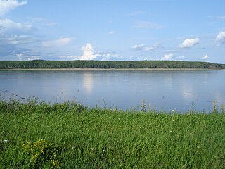
The Peace–Athabasca Delta, located in northeast Alberta, is the largest freshwater inland river delta in North America. It is located partially within the southeast corner of Wood Buffalo National Park, Canada's largest national park, and also spreads into the Regional Municipality of Wood Buffalo, west and south of the historical community of Fort Chipewyan. The delta encompasses approximately 321,200 ha, formed where the Peace and Athabasca rivers converge on the Slave River and Lake Athabasca. The delta region is designated a wetland of international importance and a UNESCO World Heritage Site. The region is large enough that it is considered one of twenty distinct natural subregions of Alberta by the provincial government's Natural Regions Committee.
The Canadian Wildlife Service or CWS, is a Branch of the Department of Environment and Climate Change Canada, a department of the Government of Canada. November 1, 2012 marked the 65th anniversary of the founding of Service.

Red Rock Lakes National Wildlife Refuge is a remote refuge located in the high elevation of the Centennial Valley, in the southwestern region of the U.S. state of Montana. Adjacent to Gallatin National Forest and near Yellowstone National Park, the refuge is an integral part of the Greater Yellowstone Ecosystem. Red Rock Lakes is best known for being the primary location for the efforts saving the trumpeter swan from extinction, which by 1932 had fewer than 200 known specimens in the United States and Canada. By the year 2002, an estimated 3,000 trumpeters were wintering on the refuge, many having migrated south from their summer range in Canada. The trumpeters are now so plentiful that efforts are being undertaken to help them reestablish historical migratory routes to areas further south in the Rocky Mountains and the Great Basin region. The elegant trumpeter swan is North America's largest waterfowl, with a wingspans of 8 feet and they can weigh up to 30 pounds (13 kg).

Necedah National Wildlife Refuge is a 43,696-acre (176.83 km2) National Wildlife Refuge located in northern Juneau County, Wisconsin near the village of Necedah. It was established in 1939 and is famous as the northern nesting site for reintroduction of an eastern United States population of the endangered whooping crane.

Dewey Soper Migratory Bird Sanctuary, or Dewey Soper, is a migratory bird sanctuary in the Qikiqtaaluk Region, Nunavut, Canada. It is located in western Baffin Island, from Bowman Bay to the Koukdjuak River, and is named in honour of zoologist J. Dewey Soper. It is an 8,159 km2 (3,150 sq mi) area that was classified a wetland of international importance via the Ramsar Convention on May 24, 1982. The bird sanctuary supports nearly 30% of the breeding geese in Canada, making it the largest goose colony in the world. Up to two million birds of various species use the area for summer nesting, and it is also "habitat for one of Canada's major barren-ground caribou herds". The sanctuary was established in 1957, and is subject to the Nunavut Land Claims Agreement, which defines and governs ownership, land use and hunting rights in the area.

Old Crow Flats is a 6,170 km2 (2,382 sq mi) wetland complex in northern Yukon, Canada along the Old Crow River. It is north of the Arctic Circle and south of the Beaufort Sea, and is nearly surrounded by mountains.

Polar Bear Pass, is a 262,400 hectare wetland and mountain pass on Bathurst Island within the Qikiqtaaluk Region, Nunavut, Canada. The pass is on federal Crown land.

The Creston Valley Wildlife Management Area is a Canadian river delta wetland and Wildlife Management Area near Creston in south-central British Columbia, on the floodplain of the Kootenay River at the south end of Kootenay Lake. Predominantly marshland, it was classified as a wetland of international importance on February 21, 1994, and is also a globally significant Important Bird Area. It is one of the "few significant agricultural areas of the province", and is in the Montane Cordillera. It stretches north along Kootenay Lake for approximately 20 km, and south to the United States border. It is both the only breeding site of the Forster's tern and the only site with leopard frogs in the province, as well as one of the few Canadian habitats for the Coeur D'Alene salamander. Creston Valley provides staging and nesting areas for migratory birds on the Pacific Flyway.

The Boreal Plains Ecozone, as defined by the Commission for Environmental Cooperation (CEC), is a terrestrial ecozone in the western Canadian provinces of Manitoba, Saskatchewan and Alberta. It also has minor extensions into northeastern British Columbia and south-central Northwest Territories. The region extends over 779,471 km2, of which 58,981 km2 is conserved.
The Taiga Plain Ecozone, as defined by the Commission for Environmental Cooperation (CEC), is a Canadian terrestrial ecozone that covers most of the western Northwest Territories, extending to northwest Alberta, northeast British Columbia and slightly overlapping northeastern Yukon.
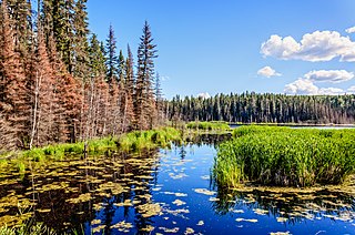
Hay-Zama Lakes is a 586-square-kilometre (226 sq mi) inland wetland and wildland park in northwestern Alberta, Canada. It was designated a Ramsar wetland of international importance on May 24, 1982, and is recognized as an Important Bird Area. It "constitutes one of the most extensive sedge wetlands in western North America".

The Central Asian Flyway (CAF), Central Asian-Indian Flyway, or Central Asian-South Asian Flyway is a flyway covering a large continental area of Eurasia between the Arctic Ocean and the Indian Ocean and the associated island chains. The CAF comprises several important migration routes of waterbirds, most of which extend from the northernmost breeding grounds in Siberia to the southernmost non-breeding wintering grounds in West Asia, India, the Maldives and the British Indian Ocean Territory.

The Muskwa-Slave Lake forests ecoregion covers Canadian taiga in northwestern Alberta, northeastern British Columbia and a large portion of the southwestern Northwest Territories around the Mackenzie River valley and the Great Slave Lake.
The Mid-Continental Canadian forests are a taiga ecoregion of Western Canada, as defined by the World Wildlife Fund (WWF) categorization system.
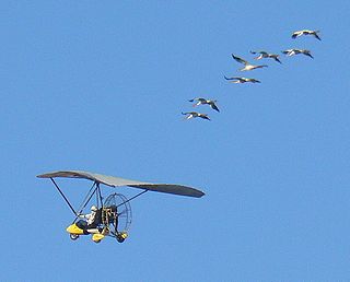
Operation Migration was a nonprofit, charitable organization, which developed a method using ultralight aircraft to teach migration to captive-raised, precocial bird species such as Canada geese, trumpeter swans, sandhill cranes, and endangered whooping cranes.
Last Mountain Lake Bird Sanctuary is a National Historic Site of Canada, located in the rural municipality of Last Mountain Valley No. 250 in Saskatchewan. The migratory bird sanctuary was the first established in North America. The 47.36 km2 (18.29 sq mi) area is within the Last Mountain Lake National Wildlife Area, an International Biological Program site, and includes adjacent uplands.
Last Mountain Lake National Wildlife Area is a National Wildlife Area (NWA) in the Canadian province of Saskatchewan. The protected area is in the Prairie Pothole Region of North America, which extends throughout three Canadian provinces and five U.S. states. It is also within Palliser's Triangle and the Great Plains ecoregion. The site is an Important Bird Area (IBA) of Canada, designated as Last Mountain Lake NWA .

