
Roebuck Bay is a bay on the coast of the Kimberley region of Western Australia. Its entrance is bounded in the north by the town of Broome, and in the south by Bush Point and Sandy Point. It is named after HMS Roebuck, the ship captained by William Dampier when he explored the coast of north-western Australia in 1699. The Broome Bird Observatory lies on the northern coast of the bay.

Eighty Mile Beach also spelled Eighty-mile Beach or 80-mile Beach, and formerly called 90-mile Beach, lies along the north-west coast of Western Australia about half-way between the towns of Broome and Port Hedland. It is a beach some 220 kilometres (140 mi) in length, forming the coastline where the Great Sandy Desert approaches the Indian Ocean. It is one of the most important sites for migratory shorebirds, or waders, in Australia, and is recognised as a wetland of international importance under the Ramsar Convention on Wetlands.
Lake Man is an area of wetlands in Okinawa that is located between the cities of Naha and Tomigusuku, and within Manko Park. Despite being called "Lake Man", it is in fact a wetland and not a lake. Lake Man covers .11 square kilometres (0.042 sq mi).

Chaplin Lake is a salt lake in the south-west corner of the Canadian province of Saskatchewan. The lake is in the Prairie Pothole Region of North America, which extends throughout three Canadian provinces and five U.S. states, and within Palliser's Triangle and the Great Plains ecoregion of Canada. Along the northern shore is the village of Chaplin, Chaplin Nature Centre, and a sodium sulphate mine owned and operated by Saskatchewan Mining and Minerals. The lake is divided into four sections by dykes built by the mining company. The Trans-Canada Highway runs along the northern shore and Highway 58 runs through the middle of the lake in a south to north direction.

Last Mountain Lake, also known as Long Lake, is a prairie lake formed from glaciation 11,000 years ago. It is located in south central Saskatchewan, Canada, about 40 kilometres (25 mi) north-west of the city of Regina. It flows into the Qu'Appelle River via Last Mountain Creek, which flows past Craven. It is approximately 93 km (58 mi) long, and 3 km (1.9 mi) wide at its widest point. It is the largest naturally occurring body of water in southern Saskatchewan. Only Lake Diefenbaker, which is man-made, is larger. The lake is a popular resort area for residents of south-eastern Saskatchewan.

Oak Hammock Marsh is a marsh and a wildlife management area located 34 kilometres (21 mi) north of Winnipeg, Manitoba, Canada. The WMA is considered to be a Class IV protected area under the IUCN protected area management categories. The marsh is recognized as an Important Bird Area (IBA) for its globally significant numbers of waterfowl and shorebirds. It is a designated Ramsar site due to its international importance as a breeding and staging area for waterfowl and other migratory birds. It is 3,578.47 hectares in size.
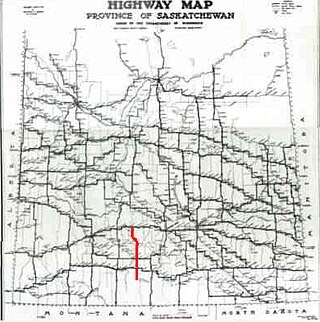
Highway 58 is an oiled surface provincial highway in the Canadian province of Saskatchewan which handles approximately 100 vehicles per day. It runs from Highway 18 3 kilometres west of Fir Mountain until Highway 1 / Highway 19 near Chaplin in the south-central area of the province. Highway 58 is about 132 kilometres (82 mi) long traversing through the Missouri Coteau. There are multiplexes of 1.6 km (1.0 mi) with Highway 13, 300 m (980 ft) with Highway 43, and 4.9 km (3.0 mi) with Highway 363.
Shepody Bay is a tidal embayment, an extension of the Bay of Fundy in New Brunswick, Canada, which consists of 77 square kilometres (30 sq mi) of open water and 40 km2 (15 sq mi) of mudflats, with 4 km2 (1.5 sq mi) of saline marsh on the west, and eroding sand and gravel beaches covering an area of approximately 1 km2 (0.39 sq mi) on the eastern shore. The intertidal mudflats "support internationally important numbers of the crustacean Corophium volutator, the principal food source for millions of fall migrating shorebirds".

Mary's Point is a 12 square kilometres (4.6 sq mi) wetland in Albert County, New Brunswick, Canada. It is at the head of the Bay of Fundy, just outside the small community of Harvey and approximately 40 km (25 mi) south of Moncton. Designated a Ramsar wetland of international importance on May 24, 1982, it is also part of the Fundy biosphere reserve established in 2007, which also contains the Shepody Bay wetland. It was also the first Canadian site in the Western Hemisphere Shorebird Reserve, as part of the Bay of Fundy Hemisphere Shorebird Reserve. It is within the Shepody Bay National Wildlife Area, which is administered by the Canadian Wildlife Service.
Lake Gore is a seasonal and semi-permanent freshwater lake in the Goldfields-Esperance region of Western Australia located approximately 24 km (15 mi) west of Esperance. It is an important site for waterbirds.

Bahia Lomas is a bay in the eastern mouth of the Strait of Magellan in Southern Chile, on the north coast of the Isla Grande de Tierra del Fuego. The area is a large tidal plain, with a tidal variation up to 7 km. The wetlands of the bay are important sites for the red knot, the Hudsonian godwit and other shorebirds. The wetlands are a Ramsar site of international importance and an Important Bird Area.

Reedy Lake, historically also known as Lake Reedy, is a shallow 5.5-square-kilometre (2.1 sq mi) intermittent freshwater lake or swamp on the lower reaches of the Barwon River, on the Bellarine Peninsula southeast of Geelong in the Australian state of Victoria.

Thomsons Lake Nature Reserve is a lake nature reserve around Thomsons Lake in the City of Cockburn, Western Australia, approximately 25 kilometres (16 mi) south of the central business district of Perth, the state capital, and on the southern fringes of the Perth metropolitan area. It is in the suburb of Beeliar, 7 kilometres (4.3 mi) south-west of Jandakot Airport. It is a still largely natural wetland, with adjoining native vegetation, surrounded by land developed for housing and agriculture, that regularly supports large numbers of shorebirds and other waterbirds.
The Western District Lakes of Victoria, in the Western District of Victoria, south-eastern Australia, were recognised on 15 December 1982 as wetlands of international importance by listing under the Ramsar Convention, as Ramsar site no.268.
The North Victorian Wetlands, also known as the Kerang Wetlands, comprise an extensive series of over 100 freshwater, brackish and saline lakes and swamps on the floodplain of the Loddon River where it enters the Murray valley, in the vicinity of the town of Kerang, in northern Victoria, south-eastern Australia. They are important for a variety, and sometimes large numbers, of waterbirds.

The Cheetham Wetlands are 420 hectares of artificial and natural lagoons, created on old salt works land on the western shores of Port Phillip Bay, Australia. The wetlands are approximately 20 kilometres (12 mi) southwest of Melbourne, and sit within the Municipal Councils of Hobsons Bay and Wyndham City.
Last Mountain Lake Bird Sanctuary is a National Historic Site of Canada, located in the rural municipality of Last Mountain Valley No. 250 in Saskatchewan. The migratory bird sanctuary was the first established in North America. The 47.36 km2 (18.29 sq mi) area is within the Last Mountain Lake National Wildlife Area, an International Biological Program site, and includes adjacent uplands.
Last Mountain Lake National Wildlife Area is a National Wildlife Area (NWA) in the Canadian province of Saskatchewan. The protected area is in the Prairie Pothole Region of North America, which extends throughout three Canadian provinces and five U.S. states. It is also within Palliser's Triangle and the Great Plains ecoregion. The site is an Important Bird Area (IBA) of Canada, designated as Last Mountain Lake NWA .

Willow Bunch Lake is a salt lake in the southern region of the Canadian province of Saskatchewan. The lake is in the Big Muddy Valley in a semi-arid region called Palliser's Triangle. There are no communities nor public facilities at the lake. The nearest town is Willow Bunch at 8 kilometres (5.0 mi) to the south and access is from Highway 36. The entire lake and its shoreline has been designated an Important Bird Area (IBA) of Canada.
Reed Lake is an intermittent, shallow endorheic salt lake in the south-western region of the Canadian province of Saskatchewan. Most of the lake and its shoreline is designated an Important Bird Area (IBA) of Canada and it is part of a Western Hemisphere Shorebird Reserve Network (WHSRN). Access to the lake is from a lookout tower and a walking path alongside the Trans-Canada Highway 2.4 kilometres (1.5 mi) west of the town of Morse.

