List of lakes of Saskatchewan

Last updated

NASA image of Saskatchewan and a portion of Manitoba. NASA image of Saskatchewan.jpg
NASA image of Saskatchewan and a portion of Manitoba.

This is a list of lakes of Saskatchewan , a province of Canada. The largest and most notable lakes are listed at the start, followed by an alphabetical listing of other lakes of the province. [1] [2]

Contents

Larger lake statistics

"The total area of a lake includes the area of islands. Lakes lying across provincial boundaries are listed in the province with the greater lake area." [3]

Saskatchewan lakes larger than 400 km2 (150 sq mi)
LakeArea (includes islands)AltitudeDepth max.Volume
Lake Athabasca [4] 7,935 km2 (3,064 sq mi)213 m (699 ft)124 m (407 ft)204 km3 (49 cu mi)
Reindeer Lake [4] 6,650 km2 (2,570 sq mi)337 m (1,106 ft)219 m (719 ft)95.25 km3 (22.85 cu mi)
Wollaston Lake [4] 2,681 km2 (1,035 sq mi)398 m (1,306 ft)97 m (318 ft)39.8 km3 (9.5 cu mi)
Cree Lake [4] 1,434 km2 (554 sq mi)487 m (1,598 ft)60 m (200 ft)17.6 km3 (4.2 cu mi)
Lac la Ronge [4] 1,413 km2 (546 sq mi)364 m (1,194 ft)42.1 m (138 ft)17.6 km3 (4.2 cu mi)
Peter Pond Lake [4] 778 km2 (300 sq mi)421 m (1,381 ft)24 m (79 ft)10.6 km3 (2.5 cu mi)
Doré Lake [4] 640 km2 (250 sq mi)459 m (1,506 ft)20.4 m (67 ft)6.68 km3 (1.60 cu mi)
Churchill Lake [5] 559 km2 (216 sq mi)421 m (1,381 ft)24 m (79 ft)4.88 km3 (1.17 cu mi)
Deschambault Lake [6] 542 km2 (209 sq mi)324 m (1,063 ft)22.4 m (73 ft)3.35 km3 (0.80 cu mi)
Frobisher Lake [7] 516 km2 (199 sq mi)421 m (1,381 ft)19 m (62 ft)2.18 km3 (0.52 cu mi)
Black Lake [3] 464 km2 (179 sq mi)281 m (922 ft)
Montreal Lake [3] 454 km2 (175 sq mi)490 m (1,610 ft)
Primrose Lake [3] 448 km2 (173 sq mi)599 m (1,965 ft)
Amisk Lake [3] 430 km2 (170 sq mi)294 m (965 ft)
Lake Diefenbaker [8] 430 km2 (170 sq mi)556.8 m (1,827 ft)66 m (217 ft)9.4 km3 (2.3 cu mi)
Pinehouse Lake [3] 404 km2 (156 sq mi)384 m (1,260 ft)
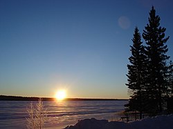
Sunrise over frozen Christopher Lake ChristopherLake Sunrise26dec06.jpg
Sunrise over frozen Christopher Lake
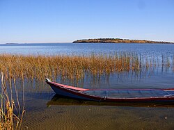
Churchill Lake at Buffalo Narrows, Saskatchewan Churchill Lake at Buffalo Narrows, Saskatchewan 2.JPG
Churchill Lake at Buffalo Narrows, Saskatchewan
Cold Lake viewed from Meadow Lake Provincial Park, Saskatchewan. Cold Lake from Meadow Lake Prov. Park, Saskatchewan.jpg
Cold Lake viewed from Meadow Lake Provincial Park, Saskatchewan.
Lake Diefenbaker Lake Diefenbaker 2007.jpg
Lake Diefenbaker
B-Say-Tah Point on Echo Lake one of the Fishing Lakes B-Say-Tah Point 2.JPG
B-Say-Tah Point on Echo Lake one of the Fishing Lakes
Ice break-up on Lac La Loche May 13, 2013 La Loche May 13, 2013.jpg
Ice break-up on Lac La Loche May 13, 2013
Last Mountain Lake Last Mountain Lake.jpg
Last Mountain Lake
Little Manitou Lake Manitou Beach Saskatchwan Gazebo 2010.jpg
Little Manitou Lake
Waskesiu Lake in Prince Albert National Park Prince Albert National Park.jpg
Waskesiu Lake in Prince Albert National Park

A

B

C

D

E

F

G

H

I

J

K

L

M

N

O

P

Q

R

S

T

U

V

W

Y

Z

See also

Related Research Articles

<span class="mw-page-title-main">Lake Diefenbaker</span> Lake in Saskatchewan, Canada

Lake Diefenbaker is a reservoir and bifurcation lake in southern part of the Canadian province of Saskatchewan. It was formed by the construction of Gardiner Dam and the Qu'Appelle River Dam across the South Saskatchewan and Qu'Appelle Rivers respectively. Construction began in 1959 and the lake was filled in 1967. The lake is 225 kilometres (140 mi) long with approximately 800 kilometres (500 mi) of shoreline. It has a maximum depth of 66 metres (217 ft), while the water levels regularly fluctuate 3–9 metres (9–27 feet) each year. The flow of the two rivers is now regulated with a considerable portion of the South Saskatchewan diverted into the Qu'Appelle. Prior to the dams' construction, high water levels in the South Saskatchewan would frequently cause dangerous ice conditions downstream in Saskatoon while the Qu'Appelle would frequently dry up in the summer months.

<span class="mw-page-title-main">Beaver River (Canada)</span> River in Western Canada

Beaver River is a large river in east-central Alberta and central Saskatchewan, Canada. It flows east through Alberta and Saskatchewan and then turns sharply north to flow into Lac Île-à-la-Crosse on the Churchill River which flows into Hudson Bay.

Deschambault Lake is a freshwater lake in the north-eastern region of the Canadian province of Saskatchewan. The identically-named community of Deschambault Lake resides on its shore. There are also four Indian reserves on the lake — Kimosom Pwatinahk 203, Mistik Reserve, Pisiwiminiwatim 207, and Muskwaminiwatim 225 — and a provincial recreation site.

<span class="mw-page-title-main">Meadow Lake Provincial Park</span> Provincial park in Saskatchewan, Canada

Meadow Lake Provincial Park is a northern boreal forest provincial recreational park along the Waterhen and Cold Rivers in the Canadian province of Saskatchewan. The park was founded on 10 March 1959, is the largest provincial park in Saskatchewan, and encompasses over 25 lakes in an area of 1,600 km2 (620 sq mi). The park was named "Meadow Lake" after the city of Meadow Lake and Meadow Lake. The city and the lake are not in the park and are located about 40 kilometres (25 mi) south-east of the nearest park entrance, which is about 5 kilometres (3.1 mi) north of Dorintosh. The length of the park stretches about 113 kilometres (70 mi) from Cold Lake on the Saskatchewan / Alberta border in the west to the eastern shore of Waterhen Lake in the east.

<span class="mw-page-title-main">Lac la Ronge</span> Glacial lake in Saskatchewan, Canada

Lac la Ronge is a glacial lake in the Canadian province of Saskatchewan. It is the fifth largest lake in the province and is approximately 250 kilometres (160 mi) north of Prince Albert, on the edge of the Canadian Shield. La Ronge, Air Ronge, and the Lac La Ronge First Nation are on the western shore. The lake is a popular vacation spot. Recreational activities include fishing, boating, canoeing, hiking, and camping.

<span class="mw-page-title-main">Amisk Lake</span> Lake in Saskatchewan, Canada

Amisk Lake is a lake in the east-central part of the Canadian province of Saskatchewan, about 22 kilometres (14 mi) south-west of Flin Flon, Manitoba. 'Amisk' means beaver in Cree. Along the lake's shores is the community of Denare Beach, a provincial recreation site with lake access and camping, and prehistoric limestone crevices. Access to the lake and its amenities is from Highway 167. Amisk Lake was on an important fur trade route in the 18th century.

<span class="mw-page-title-main">Churchill Lake</span> Lake in Saskatchewan, Canada

Churchill Lake is a glacial lake in the north-west part of the Canadian province of Saskatchewan. Frobisher Lake flows in from the north while Peter Pond Lake flows in from the east through the Kisis Channel. Highway 155 crosses this channel at the village of Buffalo Narrows.

<span class="mw-page-title-main">Frog Portage</span> Portage in Saskatchewan, Canada

Frog Portage or Portage du Traite was one of the most important portages on the voyageur route from Eastern Canada to the Mackenzie River basin. It allowed boatmen to move from the Saskatchewan River basin to the Churchill River basin. The Churchill then led west to the Mackenzie River basin. The fur trade route ran from Cumberland House, Saskatchewan north up the Sturgeon-Weir River. At its source the 300-yard Frog Portage ran, with a 20-foot drop, to Trade Lake on the Churchill a few miles west of the mouth of Reindeer River. The route then ran at least 250 miles northwest up the Churchill to Methye Portage which led to the Mackenzie basin.

<span class="mw-page-title-main">Waterhen River (Saskatchewan)</span> River in Saskatchewan, Canada

Waterhen River is an east-flowing river in the north-west area of the Canadian province of Saskatchewan in the drainage basin of the Beaver River. It is north of and parallel to the east-flowing part of the Beaver River and joins the north-flowing part of that river. Most of the river and its drainage basin is at the southern edge of the boreal forest belt. While the river's source is Lac des Îles, its drainage basin reaches north into the Mostoos Hills and west well into the neighbouring province of Alberta.

<span class="mw-page-title-main">Lac La Ronge Provincial Park</span> Provincial park in Saskatchewan, Canada

Lac La Ronge Provincial Park is located in the boreal forest of the north central part of the Canadian province of Saskatchewan within the Canadian Shield. Situated in the Churchill River system, this provincial park has close to 100 lakes and more than 30 canoe routes, many of which follow old fur trade routes. Summer activities include camping, hiking, boating, fishing, and swimming. In the winter, there's cross-country skiing, snowmobiling, and ice fishing. Saskatchewan's highest waterfall is in the park. Nistowiak Falls are located north of Lac La Ronge along the Rapid River.

<span class="mw-page-title-main">Lac Île-à-la-Crosse</span> Lake in Saskatchewan, Canada

Lac Île-à-la-Crosse is a Y-shaped lake in the north-central region of the Canadian province of Saskatchewan along the course of the Churchill River. At the centre of the "Y" is the town of Île-à-la-Crosse, the second oldest town in Saskatchewan. Situated at the confluence of the Churchill and Beaver Rivers, the lake was an important fur trading centre in the 18th and 19th centuries. The lake, and the community of Île-à-la-Crosse, are named after the game of Lacrosse as French voyageurs had witnessed local Indians playing the game on an island in the lake.

<span class="mw-page-title-main">Lac la Plonge</span> Lake in Saskatchewan, Canada

Lac la Plonge is a glacial lake in the Canadian province of Saskatchewan in the basin of the Beaver River, near Lac Île-à-la-Crosse. It is located in the boreal forest near the Canadian Shield. On the lake's northern shore, the community of Lac La Plonge, a resort, and campgrounds are accessed via Highway 165.

Waterhen Lake is a lake in Meadow Lake Provincial Park in the Canadian province of Saskatchewan, located about 40 kilometres (25 mi) north of the city of Meadow Lake. The lake is situated along the course of the Waterhen River in the boreal forest ecozone of Canada.

Moose Mountain Upland, Moose Mountain Uplands, or commonly Moose Mountain, is a hilly plateau located in the south-east corner of the Canadian province of Saskatchewan, that covers an area of about 13,000 km2 (5,000 sq mi). The upland rises about 200 m (660 ft) above the broad, flat prairie which is about 600 m (2,000 ft) above sea level. The highest peak is "Moose Mountain" at 830 m (2,720 ft) above sea level. The area was named Moose Mountain because of the large number of moose that lived in the area. When it was originally used by fur traders, Métis, and the Indigenous peoples, the plateau was called Montagne a la Bosse, which is French for "The Mountain of The Bump or Knob."

Rusty Lake is a lake in Meadow Lake Provincial Park in the Canadian Province of Saskatchewan in the boreal forest ecozone of Canada. The lake is the first of six notable lakes in the Rusty Creek watershed part of Meadow Lake Provincial Park. The other lakes include First Mustus, Second Mustus, Third Mustus, Peitahigan, and Fourth Mustus.

Lac des Îles is a lake in Meadow Lake Provincial Park in the Canadian Province of Saskatchewan in the boreal forest ecozone of Canada. The primary inflow is the Cold River and its outflow is the Waterhen River. The lake and associated rivers are part of the Hudson Bay drainage basin as the Waterhen River flows into Beaver River, which meets the Churchill River, a major river that flows into Hudson Bay, at Lac Île-à-la-Crosse.

First Mustus Lake is a lake in Meadow Lake Provincial Park in the Canadian Province of Saskatchewan in the boreal forest ecozone of Canada. The lake is the first of four lakes in a row named Mustus in the Rusty Creek watershed. The other lakes are Second, Third, and Fourth Mustus. Rusty Creek and the lakes are part of the Waterhen River drainage basin. The Waterhen River is a tributary of the Beaver River, which flows north into Lac Île-à-la-Crosse and the Churchill River, a major tributary in the Hudson Bay drainage basin. Highway 224 provides access to both First and Second Mustus Lakes.

Peitahigan Lake is a lake in Meadow Lake Provincial Park in the Canadian Province of Saskatchewan in the boreal forest ecozone of Canada. The lake is one of six notable lakes in the Rusty Creek watershed. The other lakes include Rusty, First Mustus, Second Mustus, Third Mustus, and Fourth Mustus. Rusty Creek and the lakes are part of the Waterhen River drainage basin. The Waterhen River is a tributary of the Beaver River, which flows north into Lac Île-à-la-Crosse and the Churchill River, a major tributary in the Hudson Bay drainage basin.

References

  1. "Where Nature Touches the Heart". Tourism Saskatchewan. Government of Saskatchewan. 28 November 2017. Retrieved 31 March 2022.
  2. "Saskatchewan Fishing Maps Marine Charts". GPS Nautical Charts. Bist LLC. Retrieved 31 March 2022.
  3. 1 2 3 4 5 6 Atlas of Canada. "Rivers in Canada". Archived from the original on 10 April 2007. Retrieved 17 March 2015.
  4. 1 2 3 4 5 6 7 "World Lake Database (Lakes in Canada)". Archived from the original on 14 March 2016. Retrieved 21 February 2015.
  5. "World Lake Database (Churchill Lake)". Archived from the original on 20 September 2015. Retrieved 13 October 2012.
  6. "World Lake Database (Deschambault Lake)". Archived from the original on 5 March 2016. Retrieved 21 February 2015.
  7. "World Lake Database (Frobisher Lake)". Archived from the original on 24 December 2013. Retrieved 21 February 2015.
  8. "World Lake Database (Lake Diefenbaker)". Archived from the original on 5 March 2016. Retrieved 9 January 2015.
  9. Government of Canada, Natural Resources Canada. "Place names - Waterbury Lake". www4.rncan.gc.ca.