
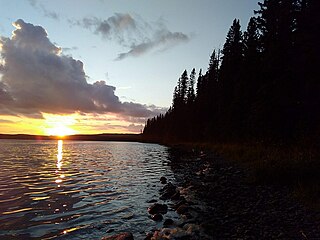
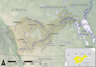
The Saskatchewan River is a major river in Canada. It stretches about 550 kilometres (340 mi) from where it is formed by the joining of the North Saskatchewan River and South Saskatchewan River just east of Prince Albert, Saskatchewan. It flows roughly eastward across Saskatchewan and Manitoba to empty into Lake Winnipeg. Through its tributaries the North Saskatchewan and South Saskatchewan, its watershed encompasses much of the prairie regions of Canada, stretching westward to the Rocky Mountains in Alberta and north-western Montana in the United States.

Carrot River is a river in Western Canada in the north-eastern part Saskatchewan and the north-western part of Manitoba. The outlet of Wakaw Lake in Saskatchewan marks the beginning of the Carrot River and, from there, it flows north-east past several communities and Indian reserves until it joins the Saskatchewan River in the Cumberland Delta in Manitoba. The river's mouth is west and upstream of the Pasquia River and The Pas on the Saskatchewan River.

Tobin Lake is a reservoir along the course of the Saskatchewan River in the Canadian province of Saskatchewan. Tobin Lake was formed by the building of the E.B. Campbell Dam on the Saskatchewan River in 1963. Tobin Lake is named for William Thorburn, who was a fur trader on the Saskatchewan River. He had built a trading post on the Saskatchewan River where it is met by the Petaigan River. The rapids near the post became known as the "Thornburn Rapids". The name was later shortened to "Tobin Rapids".

The Saskatchewan River Delta (SRD), also known as Cumberland Marshes, is a large alluvial delta that straddles the border of the provinces of Saskatchewan and Manitoba in Western Canada. Currently terminating at Cedar Lake, Manitoba, the delta is composed mainly of various types of wetlands, shallow lakes, and active and abandoned river channels bordered by forested natural levees. Sixty-five percent of the delta is occupied by vegetated wetlands, over one third of which comprise peat-forming fens and bogs. Geographically, the SRD consists of two parts – western and eastern – separated by a prominent moraine that was deposited by the Laurentide Ice Sheet during late stages of the Wisconsinan glacial epoch. These two components, commonly termed the "upper delta" and "lower delta", together occupy an area of approximately 10,000 km2 (3,900 sq mi) making the SRD one of the largest active inland deltas in North America. The broad wetland tracts of the upper delta in Saskatchewan are sometimes referred to as the Cumberland Marshes. Approximately 5% of the delta surface has been drained for agricultural use following feasibility studies by the Prairie Farm Rehabilitation Administration in the 1950s.
Porcupine Hills Provincial Park is the newest provincial park in the Canadian Province of Saskatchewan. It was created in 2018 through the amalgamation of five pre-existing provincial recreation sites south-east of the town of Hudson Bay. The park is in the Porcupine Provincial Forest in the Porcupine Hills, which is a geographical feature in eastern Saskatchewan and western Manitoba. The hills are part of a range of hills called the Manitoba Escarpment.

Plum Creek is the primary outflow for the Plum Lakes and travels in an easterly direction for about 28 kilometres until it meets up with the Souris River, which is part of the Hudson Bay drainage basin, at the community of Souris in the Canadian province of Manitoba. Plum Lakes and the beginning of Plum Creek are in the Rural Municipality of Sifton and the mouth is in the Municipality of Souris – Glenwood.
The Cub Hills are a hilly plateau located south-east of the geographical centre of the Canadian province of Saskatchewan. The hills are in the boreal forest ecozone of Canada and the landforms of the hills were shaped more than 10,000 years ago during last ice age. Throughout the Cub Hills, there are dozens of lakes and rivers and several parks. The Cubs Hills are 150 km (93 mi) north-east of Prince Albert and are in the Northern Saskatchewan Administration District and Census Division #18. Several highways criss-cross the plateau to provide access to the various parks and other amenities.
Woody Lake is a lake in the Canadian province of Saskatchewan. It is located in the east-central part of the province in the Porcupine Hills and Porcupine Provincial Forest. The entire lake is in the Woody River Block of Porcupine Hills Provincial Park. Highway 980 provides access to the lake.
Smallfish Lake is a lake in the Canadian province of Saskatchewan. It is located in the east-central part of the province right alongside the border with Manitoba in the Porcupine Hills and Porcupine Provincial Forest. The lake is part of the Woody River Block of Porcupine Hills Provincial Park and is situated in boreal forest surrounded by hills, other small lakes, and muskeg. Access to the lake is on the western side from Highway 980.
Big Shell Lake is a lake in the Canadian province of Saskatchewan. Officially known as Shell Lake, it is commonly called Big Shell Lake to differentiate it from Little Shell Lake, which is about 4.5 kilometres (2.8 mi) downstream. Big Shell Lake is in the RM of Spiritwood No. 496 and the resort villages of Big Shell and Echo Bay are on the south-eastern and eastern shore. Access to the lake and the villages is from Highway 12.

Armit River is a river in the Canadian provinces of Manitoba and Saskatchewan in the Nelson River drainage basin. The river begins in the Porcupine Hills of the Manitoba Escarpment at Armit Lake and flows in a northerly direction closely following the Manitoba / Saskatchewan border and into Red Deer Lake along the course of the Red Deer River.
Cumberland Island, also known as Pine Island, is a small island in the Saskatchewan River Delta in the east-central region of the Canadian province of Saskatchewan. The Saskatchewan River Delta is one of the largest active inland deltas in North America. Cumberland Island is situated between Cumberland Lake to the north and the Saskatchewan River to the south. The Tearing River runs along the eastern edge of the island and Bigstone River along the western edge. The Bigstone River separates Cumberland Island from Spruce Island to the west. The island is in the Mid-Boreal Lowland region, which consists of mixed coniferous and deciduous forests of white and black spruce, jack pine, tamarack, trembling aspen, balsam poplar, and balsam fir.
Birchbark Lake is a lake in the central part of the Canadian province of Saskatchewan. Most of the western half of the lake is in the RM of Paddockwood No. 520, while the eastern side is in the RM of Torch River No. 488. A provincial recreation site is located on the south-eastern shore of the lake and access is from a grid road connecting to Highway 55.
Chitek Lake is lake in the Canadian province of Saskatchewan. It is in the Mid-boreal Upland ecozone in the west-central part of Saskatchewan. Most of the lake is the RM of Big River No. 555 and only the very southernmost point is in the RM of Spiritwood No. 496. Along the lake's shores, there is the Chitek Lake Indian reserve, a community, provincial recreation area, resorts, and outfitters. The outflow is the Chitek River, which flows out from the northern end of the lake. Access is from Highway 24.
Delaronde Lake is a lake in the Canadian province of Saskatchewan. It is situated at the western edge of the Waskesiu Upland in the boreal forest ecozone of Canada. Delaronde Lake is within the Churchill River drainage basin of the Hudson Bay.
Ness Lakes are a group of five interconnected lakes — the largest of which is Ness Lake — in the Canadian province of Saskatchewan. They are in the Rural Municipality of Big River No. 555 at the western end of the Waskesiu Hills in the boreal forest ecozone of Canada. The western boundary of Prince Albert National Park is directly to the east and the town of Big River is about 15 kilometres (9.3 mi) to the south-west. Access to the lakes is from Nesslin Lake Road, which branches off of Highway 922.

MacLennan River is a river in the Canadian province of Saskatchewan. It begins at MacLennan Lake in the Thunder Hills of the Northern Saskatchewan Administration District. It then flows generally south-east out of the hills, through a section of Prince Albert National Park, and on to Montreal Lake. MacLennan River is within the Churchill River drainage basin and is in the Mid-Boreal Upland ecozone of Canada.
Overflowing River is a river in the Canadian provinces of Manitoba and Saskatchewan. It begins in Saskatchewan at Overflow Lake in the Pasquia Provincial Forest and flows in a generally eastward direction into Manitoba and then Lake Winnipegosis. The river traverses boreal forests and muskeg in the Boreal Plains Ecozone, moving from the Mid-Boreal Upland of the Pasquia Hills east to the Mid-Boreal Lowland.
Pasquia River is a river in the Canadian provinces of Manitoba and Saskatchewan. It begins in Saskatchewan in the Pasquia Hills and traverses boreal forests and muskeg in the Boreal Plains Ecozone, moving from the Mid-Boreal Upland of the Pasquia Hills east to the Mid-Boreal Lowland. It meets the Saskatchewan River in Manitoba at The Pas. Near the river's mouth, several small dams, dykes, and other water control structures have been built to control water flows.

Smoothstone Lake is a lake in the Canadian province of Saskatchewan along the course of the Smoothstone River. The lake is at the western edge of the Waskesiu Upland in the Mid-Boreal Upland ecozone of Canada and is surrounded by boreal forests. Smoothstone Lake's primary inflow and outflow is the Smoothstone River, which begins in the Waskesiu Upland and ends at Pinehouse Lake of the Churchill River. At the lake's northern end is Selenite Point, Selenite Bay, and the 362.2-hectare (895-acre) Shelter Island. Access to the lake and its amenities is from Highway 917. Highway 929 dead ends near Selenite Bay at the lake's northern end.

