List of lakes of Quebec

Last updated

This is an incomplete list of lakes of Quebec , a province of Canada.

Contents

Larger lake statistics

This is a list of lakes of Quebec with an area larger than 400 km2 (150 sq mi). [1] [2] [3] [4]

Quebec lakes larger than 400 km2 (150 sq mi)
LakeArea (including islands)AltitudeDepth max.Volume
Caniapiscau Reservoir [5] 4,318 km2 (1,667 sq mi)535 m (1,755 ft)49 m (161 ft)53.8 km3 (12.9 cu mi)
Robert-Bourassa Reservoir [5] 2,815 km2 (1,087 sq mi)175 m (574 ft)137 m (449 ft)61.7 km3 (14.8 cu mi)
La Grande-3 Reservoir [6] 2,420 km2 (930 sq mi)256 m (840 ft)
Lac Mistassini 2,335 km2 (902 sq mi)372 m (1,220 ft)
Manicouagan Reservoir [5] 1,973 km2 (762 sq mi)360 m (1,180 ft)350 m (1,150 ft)139.8 km3 (33.5 cu mi)
Gouin Reservoir 1,570 km2 (610 sq mi)404 m (1,325 ft)
Lac a l'Eau-Claire 1,383 km2 (534 sq mi)241 m (791 ft)178 m (584 ft)
Laforge-1 Reservoir 1,288 km2 (497 sq mi)
Lake Champlain 1,269 km2 (490 sq mi)
Lac Bienville 1,249 km2 (482 sq mi)426 m (1,398 ft)
Lac Saint-Jean 1,053 km2 (407 sq mi)99 m (325 ft)63.1 m (207 ft)11.9 km3 (2.9 cu mi)
Opinaca Reservoir [7] 1,040 km2 (400 sq mi)216 m (709 ft)
Pipmuacan Reservoir 978 km2 (378 sq mi)396 m (1,299 ft)13.9 km3 (3.3 cu mi)
Lake Abitibi 931 km2 (359 sq mi)
La Grande-4 Reservoir [8] 765 km2 (295 sq mi)377 m (1,237 ft)
Lake Minto 761 km2 (294 sq mi)168 m (551 ft)
Lac Guillaume-Delisle [9] 712 km2 (275 sq mi)
Cabonga Reservoir 677 km2 (261 sq mi)361 m (1,184 ft)
Outardes-4 Reservoir [5] 625 km2 (241 sq mi)24.3 km3 (5.8 cu mi)
Eastmain Reservoir 533 km2 (206 sq mi)130 m (430 ft)
Lake Manouane 584 km2 (225 sq mi)494 m (1,621 ft)
Lacs des Loups Marins 576 km2 (222 sq mi)262 m (860 ft)
Lake Evans 547 km2 (211 sq mi)232 m (761 ft)
Lac Sakami 533 km2 (206 sq mi)186 m (610 ft)
Lac Payne 533 km2 (206 sq mi)130 m (430 ft)
Lac aux Feuilles 470 km2 (180 sq mi)tidal
Lac Albanel 444 km2 (171 sq mi)389 m (1,276 ft)
Baskatong Reservoir 413 km2 (159 sq mi)223 m (732 ft)96 m (315 ft)
Dozois Reservoir 405 km2 (156 sq mi)389 m (1,276 ft)

List of Lakes

09

A

Caniapiscau Reservoir Pano Caniapiscau Reservoir.jpg
Caniapiscau Reservoir
Robert-Bourassa Reservoir Reservoir R-B.jpg
Robert-Bourassa Reservoir
Manicouagan Reservoir Manicouagan-EO.JPG
Manicouagan Reservoir
Meech Lake from Blanchet beach by south-west coast Meech-Lake.jpg
Meech Lake from Blanchet beach by south-west coast
Lac des Nations Lac des Nations.jpg
Lac des Nations
Clearwater Lakes (Lac a l'Eau-Claire) Clearwater Lakes 2013180 labels.jpg
Clearwater Lakes (Lac a l'Eau-Claire)
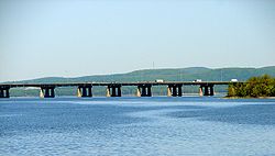
Ile aux Tourtes Bridge across Lake of Two Mountains, with Mont Oka in the background Ile-aux-Tourtes Bridge.JPG
Île aux Tourtes Bridge across Lake of Two Mountains, with Mont Oka in the background
Pingualuit crater lake Pingualuit aerial 2007.jpg
Pingualuit crater lake
Looking south over Lake Timiskaming from Fort Temiscamingue near Ville-Marie, Quebec. Fort Temiscamingue 1.jpg
Looking south over Lake Timiskaming from Fort Témiscamingue near Ville-Marie, Quebec.
Lac Walker Lacwalker.JPG
Lac Walker

B

C

D

E

F

G

H

J

K

L

M

N

O

P

R

S

T

V

W

Y

See also

Related Research Articles

<span class="mw-page-title-main">Sainte-Thècle</span> Municipality in Quebec, Canada

Sainte-Thècle is a Canadian municipality located in the province of Quebec in the Mékinac Regional County Municipality, in the Batiscanie watershed, in the administrative region of Mauricie. This municipality of 216 square kilometres is known for its resorts and many small lakes. The forest and mountain scenery offers exceptional views for tourists and vacationers. Sainte-Thècle is also a destination for hunting, fishing, snowmobile/all-terrain vehicles and other outdoor sports. The church, rectory and cemetery are located on the main hill of the village and are also heritage sites of interest. The municipality's agricultural and forestry industries have marked its history.

<span class="mw-page-title-main">Grandes-Piles</span> Village municipality in Quebec, Canada

Grandes-Piles is a village municipality in the Mauricie region of the province of Quebec in Canada.

<span class="mw-page-title-main">Lac-aux-Sables</span> Parish municipality in Quebec, Canada

Lac-aux-Sables is a parish municipality in the Mékinac Regional County Municipality, in administrative district of the Mauricie region of the province of Quebec in Canada. Its population centres are Lac-aux-Sables and Hervey-Jonction.

<span class="mw-page-title-main">Lac-Masketsi</span> Unorganized territory in Quebec, Canada

Lac-Masketsi is an unorganized territory in the Mauricie region of province of Quebec, Canada, part of the Mékinac Regional County Municipality. Most of its area is part of the Zec Tawachiche. The discharge of Masketsi Lake at the south-east flows in the Little Lake Masketsi, which empties into the Tawachiche West River.

<span class="mw-page-title-main">Rivière des Envies</span> River in Québec, Canada

Rivière des Envies is located in Canada, in the province of Quebec, in the Mauricie administrative region, in the Batiscanie. Rivière des Envies course 74 kilometres (46 mi) from the outlet of Lac-de-la-Traverse, located in row St-Joseph, Sainte-Thècle. This lake is fed by the outlet of Lake Aylwin, which in turn is fed by the discharge of Lake Jesuit.

<span class="mw-page-title-main">Tawachiche River</span> River in Quebec, Canada

TheTawachiche River flows from north to south for 25 kilometres (16 mi) entirely in the territory of the Municipality of Lac-aux-Sables, in Mékinac Regional County Municipality, in Mauricie, in the province of Quebec, Canada.

The zec Tawachiche is a zone d'exploitation contrôlée (zec) covering 318 km2, of which 310 km2 are located in Mékinac Regional County Municipality, in Mauricie, in the province of Quebec, in Canada. This zec is mainly located in the municipality of Lac-aux-Sables and in the non-organized territories of Lac-Masketsi and Lac-Lapeyrère. The zec territory is situated north of Sainte-Thècle and Saint-Tite. Located approximately 80 km north of Trois-Rivières, it is bordered to the east by Portneuf Wildlife Reserve.

<span class="mw-page-title-main">Missionary Lake</span> Lake in Trois-Rives, Quebec, Canada

Missionary Lake [formerly named "Grand lac long" ] is located in the municipalities of Trois-Rives and Lac-aux-Sables in the Mekinac Regional County Municipality (RCM), in Batiscanie, in the administrative area of the Mauricie, in the province of Quebec, Canada. It is named in honour of missionary and explorer Paul Le Jeune, one of the founders of the Jesuit mission that was opened in 1634 in nearby Trois-Rivières, Quebec.

The Mékinac Lake is a large lake of freshwater of province of Quebec (Canada), located mainly in the municipality Trois-Rives, in Mekinac Regional County Municipality, in the administrative region of Mauricie, in the province of Quebec, in Canada. The northern part of the lake and the bottom of the Bigué Bay are within the La Tuque.

<span class="mw-page-title-main">North Mékinac River</span> River in Canada

The North Mekinac River flows from North to South, in three municipalities, in Mauricie region, Mékinac Regional County Municipality, Quebec, Canada.

The Lejeune Township is located in the MRC Mekinac Regional County Municipality, in Mauricie, Quebec, Canada.

<span class="mw-page-title-main">Lake Roberge (Grandes-Piles)</span>

Lake Roberge is located in the municipality of Grandes-Piles, in the MRC Mekinac Regional County Municipality, in Mauricie, in Quebec, in Canada.

The Lake Masketsi is located in the unorganized territory of Lac-Masketsi, in the Mekinac Regional County Municipality, in Mauricie, in Quebec, in Canada.

The Roberge Lake is located in the unorganized territory of Lac-Masketsi, Quebec, the Mekinac Regional County Municipality, in Mauricie, in Quebec, in Canada. This lake whose surface is usually frozen from November to April is located entirely in forest land.

The Rivière aux eaux mortes flows entirely in forest areas in two territories Quebec, in Canada:

The Lac Fontaine is a lake located in the municipality of Grandes-Piles, in the Mékinac Regional County Municipality, in Mauricie, in Quebec, in Canada.

<span class="mw-page-title-main">Simard Lake (Gouin Reservoir)</span> Lake of reservoir in La Tuque

The Simard Lake is a freshwater body located in the northwestern part of Gouin Reservoir, in the territory of the town of La Tuque, in the administrative region of Mauricie, in the province of Quebec, in Canada.

<span class="mw-page-title-main">Miller Lake (Gouin Reservoir)</span> Lake of dam in La Tuque

Miller Lake is a body of freshwater located in the western part of the Gouin Reservoir, in the territory of the town of La Tuque, in the administrative region of the Mauricie, in the province of Quebec, in Canada.

The rivière aux Brochets is a tributary of the rivière du Milieu, flowing in the territory of the city of La Tuque and in the unorganized territory of Lac-Masketsi, in the administrative region of Mauricie, in the province of Quebec, in Canada.

References

  1. "Principal lakes, elevation and area, by province and territory". Statistics Canada. 2005-02-02. Retrieved 2015-03-11.
  2. "World Lake Database (Lakes in Canada)". Archived from the original on 2016-03-14. Retrieved 2015-02-21.
  3. Atlas of Canada. "Rivers in Canada". Archived from the original on 10 April 2007. Retrieved 2015-03-17.
  4. fr:Liste des lacs du Canada#Québec
  5. 1 2 3 4 Hydro-Québec - Cinq principaux réservoirs d'Hydro-Québec
  6. "Commission de toponymie du Québec - Banque des noms de lieux - Toponyme: "Réservoir La Grande 3"" . Retrieved 2015-04-17.
  7. "Commission de toponymie Quebec (Reservoir Opinaca)". Archived from the original on 2015-04-02. Retrieved 2015-03-21.{{cite web}}: CS1 maint: bot: original URL status unknown (link)
  8. "La Grande-4". Commission de toponymie - Quebec. Retrieved 22 April 2020.
  9. "Lac Guillaume-Delisle" (in French). Commission de toponymie du Québec. Archived from the original on 2015-04-02. Retrieved 2009-01-27.
  10. "Fiche descriptive - Lac Lancre" (in French). Commission de toponymie. Retrieved August 16, 2015.