List of lakes of Costa Rica

Last updated
Map all coordinates using: OpenStreetMap  
Download coordinates as: KML  ·  GPX

This is a list of lakes, reservoirs, and water bodies in Costa Rica. [1]

NameTypeElevation (m)Area (km²)Depth (m)Coordinates
L. Arenal artificial54080.769055.00 10°31′05″N84°54′03″W / 10.518°N 84.9008°W / 10.518; -84.9008
L. Asunciónartificial?33400.00051.00 9°34′34″N83°45′32″W / 9.576°N 83.759°W / 9.576; -83.759
L. Barvacrater28400.00807.90 10°08′06″N84°06′25″W / 10.135°N 84.107°W / 10.135; -84.107
L. Bonilla landslide3800.308027.00 9°59′33″N83°36′07″W / 9.992635°N 83.602042°W / 9.992635; -83.602042
L. Bonillita landslide4500.060020.00 9°59′32″N83°36′41″W / 9.992089°N 83.611465°W / 9.992089; -83.611465
L. Bosque Alegre crater7400.00604.00 10°17′57″N84°13′07″W / 10.299208°N 84.218698°W / 10.299208; -84.218698
L. Botos crater25800.10339.00 10°11′14″N84°13′38″W / 10.187086°N 84.227267°W / 10.187086; -84.227267
L. Cachí reservoir9703.240080 9°49′38″N83°49′00″W / 9.827222°N 83.816667°W / 9.827222; -83.816667
L. Las Camelias (wildlife refuge) [ citation needed ] 10°57′46″N85°06′05″W / 10.9628°N 85.1014°W / 10.9628; -85.1014
L. Campo Dosartificial10360.00101.50 8°43′37″N82°56′13″W / 8.727°N 82.937°W / 8.727; -82.937
L. Campo Tresartificial10970.00102.60 8°43′23″N82°56′06″W / 8.723°N 82.935°W / 8.723; -82.935
L. Cararaoxbow160.02103.50 9°48′00″N84°35′53″W / 9.8°N 84.598°W / 9.8; -84.598
L. Castilloartificial7500.00103.50 9°01′59″N83°35′35″W / 9.033°N 83.593°W / 9.033; -83.593
L. Cedeñolandslide6100.06403.00 10°29′05″N84°42′12″W / 10.484835°N 84.703333°W / 10.484835; -84.703333
L. Cerro Chatocrater10500.028017.90 10°26′38″N84°41′28″W / 10.444°N 84.691°W / 10.444; -84.691
L. Chirripó 1glacial35200.078022.00 9°29′06″N83°29′53″W / 9.485°N 83.498°W / 9.485; -83.498
L. Chitaríaartificial7200.00031.00 9°56′13″N83°35′49″W / 9.937°N 83.597°W / 9.937; -83.597
L. Cocoritosartificial5200.00201.00 10°22′37″N84°37′52″W / 10.377°N 84.631°W / 10.377; -84.631
L. Congo crater7400.149014.60 10°18′19″N84°12′59″W / 10.305262°N 84.216443°W / 10.305262; -84.216443
L. Copeycrater24600.00502.00 10°08′20″N84°05′35″W / 10.139°N 84.093°W / 10.139; -84.093
L. Cote crater?6501.983011.00 10°34′59″N84°54′43″W / 10.583°N 84.912°W / 10.583; -84.912
L. Cuipilapaartificial4800.00101.90 10°40′12″N85°09′50″W / 10.67°N 85.164°W / 10.67; -85.164
L. Ditkebiglacial34930.01207.00 9°28′12″N83°28′55″W / 9.47°N 83.482°W / 9.47; -83.482
L. Espabelosalava flow4400.00603.00 10°39′40″N85°10′59″W / 10.661°N 85.183°W / 10.661; -85.183
L. Estero Blancolava flow4300.01502.80 10°40′01″N85°12′14″W / 10.667°N 85.204°W / 10.667; -85.204
L. Fosterartificial400.00031.50 8°41′24″N83°06′07″W / 8.69°N 83.102°W / 8.69; -83.102
L. Fraijaneslandslide16500.22006.20 10°07′31″N84°11′28″W / 10.125312°N 84.191079°W / 10.125312; -84.191079
L. Gamboawetland14600.00302.00 8°43′19″N82°59′17″W / 8.722°N 82.988°W / 8.722; -82.988
L. Gandocaoxbow00.07306.40 9°35′13″N82°36′14″W / 9.587°N 82.604°W / 9.587; -82.604
L. Gonzálezlandslide7100.00608.10 10°17′12″N84°27′51″W / 10.286717°N 84.464253°W / 10.286717; -84.464253
L. Hule crater7400.547019.80 10°17′43″N84°12′32″W / 10.295278°N 84.208889°W / 10.295278; -84.208889
L. Jalapa [ citation needed ] 10°31′53″N84°01′53″W / 10.531514°N 84.031380°W / 10.531514; -84.031380
L. La Palmalava flow5700.050010.80 10°29′13″N84°42′58″W / 10.487°N 84.716°W / 10.487; -84.716
L. Lancaster Abajo landslide3300.050016.90 10°00′46″N83°35′47″W / 10.012714°N 83.596446°W / 10.012714; -83.596446
L. Lancaster Arriba landslide4300.01302.00 10°01′16″N83°35′44″W / 10.021014°N 83.595426°W / 10.021014; -83.595426
L. Las Brisaslava flow3000.00802.20 10°39′00″N85°12′04″W / 10.65°N 85.201°W / 10.65; -85.201
L. Los Juncos Farlava flow4400.01001.80 10°40′08″N85°11′24″W / 10.669°N 85.19°W / 10.669; -85.19
L. Los Juncos Nearlava flow4400.00801.70 10°40′05″N85°11′28″W / 10.668°N 85.191°W / 10.668; -85.191
L. Madre Viejaoxbow160.03003.00 9°48′36″N84°35′53″W / 9.81°N 84.598°W / 9.81; -84.598
L. Manuel [ citation needed ]-20000.0273- 9°41′22″N83°58′42″W / 9.689420°N 83.978430°W / 9.689420; -83.978430
L. Maquenque [ citation needed ] 10°45′07″N84°06′13″W / 10.751869°N 84.103543°W / 10.751869; -84.103543
L. Maria Aguilarlandslide7700.02706.90 10°18′04″N84°11′17″W / 10.301054°N 84.187946°W / 10.301054; -84.187946
L. Martilletelava flow4100.03502.50 10°39′14″N85°11′38″W / 10.654°N 85.194°W / 10.654; -85.194
L. Morrenas 0glacial34960.01102.90 9°29′31″N83°29′06″W / 9.492°N 83.485°W / 9.492; -83.485
L. Morrenas 1glacial34770.05608.30 9°29′38″N83°29′13″W / 9.494°N 83.487°W / 9.494; -83.487
L. Morrenas 2glacial34750.02301.30 9°29′42″N83°29′24″W / 9.495°N 83.49°W / 9.495; -83.49
L. Morrenas 2aglacial35320.00900.90 9°29′N83°29′W / 9.49°N 83.49°W / 9.49; -83.49
L. Morrenas 3glacial34720.03108.10 9°24′29″N83°29′24″W / 9.408°N 83.49°W / 9.408; -83.49
L. Morrenas 4glacial34660.00603.00 9°30′00″N83°29′20″W / 9.5°N 83.489°W / 9.5; -83.489
L. Osa lartificial300.00201.50 8°41′02″N83°30′18″W / 8.684°N 83.505°W / 8.684; -83.505
L. Paraguas [ citation needed ] 8°47′21″N82°59′16″W / 8.789164°N 82.987734°W / 8.789164; -82.987734
L. Peje [ citation needed ] 10°10′44″N83°29′52″W / 10.178900°N 83.497800°W / 10.178900; -83.497800
L. Poco Sol landslide7760.029011.30 10°21′07″N84°40′19″W / 10.352°N 84.672°W / 10.352; -84.672
L. Pozo Verde landslide1950 10°15′45″N84°21′21″W / 10.262385°N 84.355764°W / 10.262385; -84.355764
L. Ramirezcrater?5700.01002.50 10°43′55″N85°01′01″W / 10.732°N 85.017°W / 10.732; -85.017
L. Refugioglacial34500.00900.90 9°30′11″N83°29′35″W / 9.503°N 83.493°W / 9.503; -83.493
L. Río Cuarto crater3800.315066.00 10°21′25″N84°12′59″W / 10.356944°N 84.216389°W / 10.356944; -84.216389
L. San Franciscoartificial900.00302.50 10°27′29″N84°24′18″W / 10.458°N 84.405°W / 10.458; -84.405
L. San Joaquínwetland9760.05401.00 8°49′41″N82°57′11″W / 8.828°N 82.953°W / 8.828; -82.953
P. San Miguelswamp100.30002.00 9°34′23″N82°38′53″W / 9.573°N 82.648°W / 9.573; -82.648
L. San Pablolava flow4500.04502.50 10°39′40″N85°10′48″W / 10.661°N 85.18°W / 10.661; -85.18
L. San Vitoartificial9900.00203.50 8°49′37″N82°57′36″W / 8.827°N 82.96°W / 8.827; -82.96
L. Sierpewetland161.02802.20 8°46′55″N83°19′41″W / 8.782°N 83.328°W / 8.782; -83.328
L. Tres de Junioartificial26700.00051.50 9°40′01″N83°51′07″W / 9.667°N 83.852°W / 9.667; -83.852
L. Universityartificial7600.00901.00 9°21′47″N83°41′38″W / 9.363°N 83.694°W / 9.363; -83.694
L. Vaca Blancaartificial940.00502.50 10°27′18″N84°23′49″W / 10.455°N 84.397°W / 10.455; -84.397
L. Vueltaslandslide2700.00303.00 8°58′01″N83°10′41″W / 8.967°N 83.178°W / 8.967; -83.178
L. Zentoxbow170.01302.00 10°01′55″N83°16′55″W / 10.032°N 83.282°W / 10.032; -83.282
L. Zoncholandslide11900.00802.60 8°48′47″N82°57′47″W / 8.813°N 82.963°W / 8.813; -82.963

See also

Related Research Articles

History of Costa Rica Historical development of Costa Rica

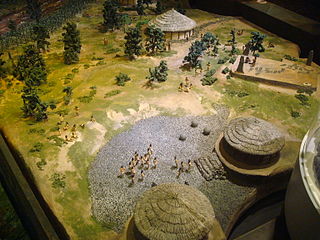
The first indigenous peoples of Costa Rica were hunters and gatherers, and when the Spanish conquerors arrived, Costa Rica was divided in two distinct cultural areas due to its geographical location in the Intermediate Area, between Mesoamerican and the Andean cultures, with influences of both cultures.

Limnology The science of inland aquatic ecosystems

Limnology, is the study of inland aquatic ecosystems. The study of limnology includes aspects of the biological, chemical, physical, and geological characteristics and functions of inland waters. This includes the study of lakes, reservoirs, ponds, rivers, springs, streams, wetlands, and groundwater. A more recent sub-discipline of limnology, termed landscape limnology, studies, manages, and seeks to conserve these ecosystems using a landscape perspective, by explicitly examining connections between an aquatic ecosystem and its drainage basin. Recently, the need to understand global inland waters as part of the Earth System created a sub-discipline called global limnology. This approach considers processes in inland waters on a global scale, like the role of inland aquatic ecosystems in global biogeochemical cycles.

Oncilla Small wild cat

The oncilla, also known as the northern tiger cat, little spotted cat, and tigrillo, is a small spotted cat ranging from Central America to central Brazil. It is listed as Vulnerable on the IUCN Red List because the population is threatened by deforestation and conversion of habitat to agricultural land.

Michael Umaña Costa Rican footballer

Míchael Umaña Corrales is a Costa Rican footballer who plays as a defender for Comunicaciones in the Liga Nacional.

Mangue, also known as Chorotega, is an extinct Oto-Manguean language indigenous to Nicaragua, Honduras and Costa Rica. The ethnic population numbered around 10,000 in 1981. Chorotega-speaking peoples included the Mangue and Monimbo. The dialects were known as: Mangue proper in western Nicaragua, which was further subdivided into Dirian and Nagrandan; Choluteca in the region of Honduras' Bay of Fonseca; and Orotiña in Costa Rica's Nicoya Peninsula.

<i>Atelopus varius</i>

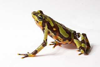
Atelopus varius, the Costa Rican variable harlequin toad or clown frog, is a small Neotropical true toad from the family Bufonidae. Once ranging from Costa Rica to Panama, A. varius is now listed as critically endangered and has been reduced to a single remnant population near Quepos, Costa Rica and has only relict populations in western Panama (IUCN). Recent variation in air temperature, precipitation, stream flow patterns, and the subsequent spread of a pathogenic chytrid fungus (Batrachochytrium dendrobatidis) linked to global climate change have been the leading cause of decline for A. varius. A. zeteki has been considered a subspecies of A. varius, but is now generally considered a separate species.

Costa Rica's official and predominant language is Spanish. The variety spoken there, Costa Rican Spanish, is a form of Central American Spanish.

Index of Costa Rica–related articles Wikipedia list article

The following is an alphabetical list of topics related to the Republic of Costa Rica.

The Cabécar language is an indigenous American language of the Chibchan language family which is spoken by the Cabécar people in Costa Rica. Specifically, it is spoken in the inland Turrialba Region of the Cartago Province. 80% of speakers are monolingual; as of 2007, it is the only indigenous language in Costa Rica with monolingual adults. The language is also known by its dialect names Chirripó, Estrella, Telire, and Ujarrás.

Abortion in Costa Rica is severely restricted by criminal law. Currently, abortions are allowed in Costa Rica only in order to preserve the life or physical health of the woman. Abortions are illegal in almost all cases, including when the pregnancy is a result of rape or incest and when the fetus suffers from medical problems or birth defects. Both social and economic factors have led to this legal status. It remains unclear whether abortions are legal to preserve the mental health of the woman, though the 2013 United Nations abortion report says Costa Rica does allow abortions concerning mental health of a woman.

Arturo Agüero Chaves, was a Costa Rican writer, poet, philologist, lexicographer and educator. Along with Aquileo J. Echeverría, he is one of the greatest exponents of Costa Rican costumbrismo. He is also considered the father of modern linguistics in Costa Rica.

Epiperipatus biolleyi is a species of velvet worm in the Peripatidae family. The type locality is in Costa Rica.

The 1886 Costa Rican general election was held on 4 April 1886. After the death of Próspero Fernández Oreamuno in March 1885, Bernardo Soto Alfaro took over the presidency temporarily for the remainder of the term. Soto was a thirty-year-old young man who had to command the country in the war against Guatemala that sought to re-establish the Federal Republic of Central America. Soto was a freemason and liberal, belonging to "The Olympus", a group of liberal intellectuals who would have a great influence on Costa Rican politics and many would hold the Presidency of the Republic.

Cinema of Costa Rica refers to the film industry based in Costa Rica. The Costa Rican cinema comprises the art of film and creative movies made within the nation of Costa Rica or by Costa Rican filmmakers abroad.

Lake Cote lagoon in Costa Rica

Lake Cote, originally known as Lake Cóter, is a fresh water crater lake located in the northern highlands of Costa Rica. It is currently the largest natural lake in Costa Rica at 1.98-square-kilometre (0.76 sq mi). Its depth varies between 6 and 18 meters.

Lake Río Cuarto Laguna de Costa Rica

Lake Río Cuarto, is a fresh water crater lake located in the northern highlands of Costa Rica. It is currently the deepest natural lake in Costa Rica at 66-metre (217 ft).

Lake Botos Lake in Costa Rica

Lake Botos, is a crater lake located inside the Poás Volcano National Park..

Lake Lancaster Arriba Lake in Costa Rica

Lake Lancaster Arriba, together with Lake Lancaster Abajo are part of two lakes in the Limón province of Costa Rica, collectively referred as the Lancaster Lakes.

Lake Congo Lake in Costa Rica

Lake Congo, is a fresh water crater lake located in the northern highlands of Costa Rica. It is part of a complex of lakes comprising Lake Hule, Lake Congo and Lake Bosque Alegre. They are included in the Bosque Alegre Wildlife Refuge of the Costa Rica National Parks.

References

  1. Haberyan, K.A.; Horn, S.P.; Umana V, G. (March 2003). "Basic limnology of fifty-one lakes in Costa Rica". Revista de Biología Tropical. 51 (1). Retrieved 10 April 2020..