List of lakes of British Columbia

Last updated

This is an incomplete list of lakes of British Columbia , a province of Canada.

Contents

Larger lake statistics

British Columbia lakes larger than 400 km2 (150 sq mi)
LakeArea (including islands)AltitudeMax. depthVolume
Williston Lake [1] 1,761 km2 (680 sq mi)671 m (2,201 ft)
Nechako Reservoir 890 km2 (340 sq mi)853 m (2,799 ft)305 m (1,001 ft)
Atlin Lake [1] 775 km2 (299 sq mi)668 m (2,192 ft)
Babine Lake [1] 495 km2 (191 sq mi)711 m (2,333 ft)
Kootenay Lake [1] 407 km2 (157 sq mi)532 m (1,745 ft)

* "Nechako Reservoir". BC Geographical Names .

List of lakes

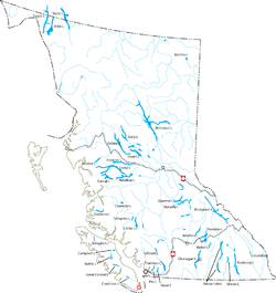
Lakes of British Columbia. See actual size. Canada BC lakes map.png
Lakes of British Columbia. See actual size.
Alouette Lake at Sunrise Alouette Lake at Sunrise (15313912022).jpg
Alouette Lake at Sunrise
Atlin Lake Atlinlake.jpg
Atlin Lake
Babine Lake Babine Lake with huts (321870589).jpg
Babine Lake
Lost Lagoon in Vancouver's Stanley Park Vancouver-stanley-park.jpg
Lost Lagoon in Vancouver's Stanley Park
View of the Okanagan valley from the hills above Kelowna Okanagan.jpg
View of the Okanagan valley from the hills above Kelowna
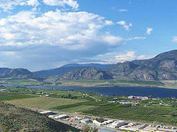
Osoyoos Lake Osoyoos.jpg
Osoyoos Lake
Quesnel Lake - Hurricane Point Quesnel Lake - Hurricane Point.jpg
Quesnel Lake - Hurricane Point
Williston Lake Wiliston lake barge.JPG
Williston Lake

1

A

Azouzetta Lake Azouzetta Lake in the Northern Rockies along John Hart Hwy^^Dans les Rocheuses du Nord BC^^Azu Lake in The local slang - panoramio.jpg
Azouzetta Lake

B

C

D

E

F

G

H

I

J

K

L

M

N

O

P

Q

R

S

Sheridan Lake

T

U

V

W

X

Y

See also

Related Research Articles

<span class="mw-page-title-main">Index of British Columbia–related articles</span>

The following is an alphabetical list of articles related to the Canadian province of British Columbia.

BC Transit is a provincial crown corporation responsible for coordinating the delivery of public transportation within British Columbia, Canada, outside Greater Vancouver. BC Transit is headquartered in Victoria, British Columbia. In 2023, the system had a ridership of 26,377,500, or about 108,500 per weekday as of the fourth quarter of 2023.

<span class="mw-page-title-main">Geography of British Columbia</span>

British Columbia is the westernmost province of Canada, bordered by the Pacific Ocean. With an area of 944,735 km2 (364,764 sq mi) it is Canada's third-largest province. The province is almost four times the size of the United Kingdom and larger than every United States state except Alaska. It is bounded on the northwest by the U.S. state of Alaska, directly north by Yukon and the Northwest Territories, on the east by Alberta, and on the south by the U.S. states of Washington, Idaho, and Montana. Formerly part of the British Empire, the southern border of British Columbia was established by the 1846 Oregon Treaty. The province is dominated by mountain ranges, among them the Canadian Rockies but dominantly the Coast Mountains, Cassiar Mountains, and the Columbia Mountains. Most of the population is concentrated on the Pacific coast, notably in the area of Vancouver, located on the southwestern tip of the mainland, which is known as the Lower Mainland. It is the most mountainous province of Canada.

<span class="mw-page-title-main">Sx̱ótsaqel/Chilliwack Lake Provincial Park</span> Provincial park in British Columbia, Canada

Sx̱ótsaqel/Chilliwack Lake Provincial Park is a provincial park in British Columbia, Canada. Covering 92.58 km2, the park is located 150 km east of Vancouver in the Chilliwack River Valley.

Emergency Support Services (ESS) is a component of Emergency Management British Columbia. As of March 2023, EMBC became part of the B.C. Ministry of Emergency Management and Climate Readiness ESS are those services required to preserve the well-being of people affected by an emergency or disaster. Teams are established in local municipalities and assemble together for meetings and contingency planning.

The Nechako Plateau is the northernmost subdivision of the Interior Plateau, one of the main geographic regions of the Canadian province of British Columbia. It spans the basin of the Nechako River and its tributaries the Stuart River and Endako Rivers, and is bounded on the south by the West Road River, south of which is the Chilcotin Plateau and on the north by the Nation River and the valleys of Babine and Takla Lakes, beyond which are the Omineca Mountains (N) and Skeena Mountains (NW). To the west, it abuts the various ranges of the Hazelton Mountains while on its east it is bounded by the pass between Prince George, British Columbia and the Parsnip Arm of Williston Lake, beyond which is the McGregor Plateau, which skirts the Northern Rockies. Some classification systems include the plateau area on the east bank of the Fraser River beyond the city of Prince George; this area neighbours the northernmost reaches of the Quesnel Highland and Cariboo Mountains.

<span class="mw-page-title-main">British Columbia Interior</span> Interior region of British Columbia, Canada

The British Columbia Interior, popularly referred to as the BC Interior or simply the Interior, is a geographic region of the Canadian province of British Columbia. While the exact boundaries are variously defined, the British Columbia Interior is generally defined to include the 14 regional districts that do not have coastline along the Pacific Ocean or Salish Sea, and are not part of the Lower Mainland. Other boundaries may exclude parts of or even entire regional districts, or expand the definition to include the regional districts of Fraser Valley, Squamish–Lillooet, and Kitimat–Stikine.

An electoral redistribution was undertaken in 2008 in British Columbia in a process that began in late 2005 and was completed with the passage of the Electoral Districts Act, 2008 on April 10, 2008. The redistribution modified most electoral boundaries in the province and increased the number of MLAs from 79 to 85. The electoral boundaries created by the redistribution were first used in the 2009 provincial election.

An electoral redistribution in British Columbia was undertaken by the BC Electoral Boundaries Commission beginning in 2014 and was formalized by the passage of Bill 42, the 2015 Electoral Districts Act, during the 40th British Columbia Parliament. The act came into effect on November 17, 2015. The redistribution added two seats to the previous total, increasing the number of MLAs in the province from 85 to 87. The electoral boundaries came into effect for the 2017 election. The next redistribution is required to occur following the 2020 British Columbia general election.

<span class="mw-page-title-main">2022 British Columbia municipal elections</span>

The 2022 British Columbia municipal elections were held on 15 October 2022. Municipal elections took place in all municipalities and regional district electoral areas in the Canadian province of British Columbia to elect mayors, school board trustees, rural directors and city councillors. Elections BC administered campaign financing, disclosure and advertisement of candidates; however, voting, ballots and candidate nominations were administered by each jurisdiction's local electoral officer.

An electoral redistribution in British Columbia is underway by the BC Electoral Boundaries Commission. On October 21, 2021, the Government of British Columbia appointed Justice Nitya Iyer, Linda Tynan and Chief Electoral Officer Anton Boegman to serve as the 2021 commissioners. Justice Iyer was appointed the chair.

References

  1. 1 2 3 4 Atlas of Canada. "Rivers in Canada". Archived from the original on 10 April 2007. Retrieved 2015-03-17.