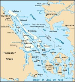
Galiano Island is one of the Southern Gulf Islands located between Vancouver Island and the Lower Mainland of British Columbia, Canada. Located on the west side of the Strait of Georgia, the island is bordered by Mayne Island to the southeast, Salt Spring Island to the west and Valdes Island to the northwest. Galiano is part of the Capital Regional District Electoral Area G, and has a permanent population of 1,044 inhabitants as of 2016.
Penelakut Island, formerly known as Kuper Island and renamed in 2010 in honour of the Penelakut First Nation people, is located in the southern Gulf Islands between Vancouver Island and the mainland Pacific coast of British Columbia, Canada. The island has a population of about 300 members of the Penelakut Band. The island has an area of 8.66 square kilometres (3.34 sq mi). There is frequent car and passenger ferry service to Penelakut from Chemainus on Vancouver Island. On its west side sits Telegraph Harbour.

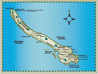
Thetis Island is an island and unincorporated community off the coast of British Columbia, Canada, lying between Vancouver Island, which is to the west across Stuart Channel, and the west from the north tip of Galiano Island, from which it is separated by Trincomali Channel. With its immediate southern neighbour Penelakut Island, it is one of the Gulf Islands. Thetis island is 2,560 acres (1,036 ha) in size. It is approximately two miles wide and three miles long north to south. Two north to south land ridges define the east and west sides of the island. Burchell Hill is 591 feetabove sea level, and forms the high point on the west side of Thetis island, and Moore Hill is 585 feet above sea level, and forms the high point ridge on the east side of the island.

Wallace Island Marine Provincial Park is a provincial park in the Gulf Islands of British Columbia, Canada. The park includes almost all 72 hectares of Wallace Island. Land on the northern side of Princess Cove extending north towards Chivers is private. This long, thin island lies in Trincomali Channel south-west of Galiano Island, and about 2 km (1.2 mi) northeast of Saltspring Island. There are a few hiking trails, and camping is permitted in designated areas.

De Courcy Island is one of the Gulf Islands located between Pylades and Stuart Channels approximately 16 km (9.9 mi) south-east of Nanaimo, British Columbia and approximately 38 km (24 mi) south-west of Vancouver, British Columbia. The island was named after Michael de Courcy, captain of HMS Pylades and is about 460 acres (186.2 ha) in area.

Cortes Island is an island in the Discovery Islands archipelago on the coast of British Columbia, Canada. The island is 25 km (15.5 mi) long, 13 km (8.1 mi) wide, and 130 km2 (50 sq mi) in area. It has a population of 1,035 permanent residents. Cortes Island lies within Electoral Area B of the Strathcona Regional District, which provides water and sewerage systems, fire protection, land use planning, parks, recreation, and emergency response.
King Island is an island on the Coast of the Canadian province of British Columbia. It is located south of Dean Channel and about 20 kilometres (12 mi) east of Bella Bella. A number of other islands separate King Island from the open sea of Queen Charlotte Sound.

Discovery Passage is a strait that forms part of the Inside Passage between Vancouver Island and the Discovery Islands of British Columbia. The strait is considered the most important natural passage for vessels' entering or leaving the Salish Sea from the north.
Haro Strait, often referred to as the Haro Straits because it is really a series of straits, is one of the main channels connecting the Strait of Georgia to the Strait of Juan de Fuca, separating Vancouver Island and the Gulf Islands in British Columbia, Canada from the San Juan Islands of Washington state in the United States.

Active Pass is a strait separating Galiano Island in the north and Mayne Island in the south in the southern Gulf Islands, British Columbia, Canada. It connects the Trincomali Channel in the west and the Strait of Georgia in the east. The pass stretches 5.5 km from northeast to southwest with two roughly right angle bends at each end.
Parker Island is a roughly 400-acre (160 ha) island in the Southern Gulf Islands of British Columbia, Canada. It forms the western side of Montague Harbour, sheltering it from the strong wind gusts of Trincomali Channel. The island may be reached by floatplane, private boat,helicopter or water taxi; there is no public ferry service.

Sutil Channel is a broad strait located in the Discovery Islands of British Columbia, Canada.

Fitz Hugh Sound, sometimes spelled Fitzhugh Sound, is a sound on the British Columbia Coast of Canada, located between Calvert Island and the mainland.

Portland Island is an island of the Southern Gulf Islands of the South Coast of British Columbia, Canada. It is located in the Salish Sea west of Moresby Island and off the south tip of Saltspring Island, adjacent to the main BC Ferries route just offshore from the terminal at Swartz Bay at the tip of the Saanich Peninsula. It was named after HMS Portland, the flagship of Rear-Admiral Fairfax Moresby, Commander in Chief of the Pacific Station 1850–1853.
Trincomalee may refer to:
Yeo Island is an island in the North Coast region of British Columbia, Canada. It is separated from the Don Peninsula to its west by Spiller Channel, and from the Coldwell Peninsula to its east by Bullock Channel. It was first charted and circumnavigated in 1793 by James Johnstone, one of George Vancouver's lieutenants during his 1791-95 expedition.
Hanson Island is an island in the Queen Charlotte Strait region of the Central Coast of British Columbia, located west of Harbledown Island and south of the Plumper Islands. The westernmost part of Johnstone Strait is to the south of the island, Blackfish Sound to the north, beyond which is Swanson Island. The island is named for James Hanson who served aboard HMS Chatham in 1792 and was later transferred that year to command Vancouver's supply ship HMS Daedalus.

Call Inlet is an inlet on the Central Coast region of British Columbia, Canada, located south of the lower reaches of Knight Inlet to the east of East Cracroft Island. Pawala Indian Reserve No. 5 is at the head of the inlet. Chatham Channel connects the outlet of the inlet to Knight Inlet and separates East Cracroft Island from the mainland peninsula on the north side of the inlet. Havannah Channel leads southwest out of the inlet, south and east around East Cracroft and past Hull Island, to Johnstone Strait.
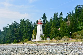
Cape Mudge Lighthouse is located on Quadra Island which is off Campbell River, on the east coast of Vancouver Island, British Columbia, Canada.

Hardy Island is an island of the Northern Gulf Islands archipelago located in the Sunshine Coast region of British Columbia.