Milbanke Sound

Last updated
Milbanke Sound
Milbanke Sound Group.jpg
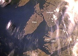
Satellite image of Milbanke Sound
Canada British Columbia relief location map.jpg
Red pog.svg
Milbanke Sound
Location in British Columbia
Location British Columbia, Canada
Coordinates 52°19′N128°33′W / 52.317°N 128.550°W / 52.317; -128.550
Type Sound
Ocean/sea sources Pacific Ocean

Milbanke Sound is a sound on the coast of the Canadian province of British Columbia. [1]

Contents

Geography

Milbanke Sound extends east from Queen Charlotte Sound, with Price Island on the west, Swindle Island on the north, and the Bardswell Group of islands on the south. [2] Milbanke Sound is one of the open sea portions of the Inside Passage, with Seaforth Channel joining from the east and Finlayson Channel from the north. [3] [4] Mathieson Channel also connects to Milbanke Sound from the north, and leads to Fiordland Conservancy.

On the islands surrounding the sound is a group of five volcanos called the Milbanke Sound cones. [5]

History

The Heiltsuk peoples traditionally occupied the land around Milbanke Sound. [6] [7] [8]

In late June, 1788, the British fur trader Charles Duncan, captain of Princess Royal, entered Milbanke Sound, which was then uncharted waters. He spent a few days trading with the Heiltsuk. [9] He named the sound after Vice Admiral Mark Milbanke. [10] Explorer George Vancouver sailed through the sound a few years later. [8] [11] In 1805, a trading ship from Boston, the Atahualpa, was attacked by a group of Tlingit; the captain and some of the crew were killed. [12] [13]

In 1833 the Hudson's Bay Company established Fort McLoughlin in the Milbanke Sound area. [14] [15] William Fraser Tolmie was stationed there in 1833-1834. Tolmie wrote about the fur trade in the area, saying that it was conducted with the Coast Tsimshians and Heiltsuks, using a pidgin jargon composed of the Kaigani and Tshatshinni dialects of Haida and English. Chinook Jargon, commonly used elsewhere, was not widely known in Milbanke Sound at the time. [16] The fort operated for about ten years, and then was abandoned; the company later opened a small store at the same location. [17]

To improve the safety of the developing travel and shipping lanes, a lighthouse was built in 1898 at Robb Point on Ivory Island. [18]

In recent times archaeological investigations have been carried out in the Milbanke Sound area. [19] [20]

Economy

The sound is popular with sports fishing enthusiasts. [21]

See also

Related Research Articles

<span class="mw-page-title-main">Inside Passage</span> Shipping route along the northwest coast of North America

The Inside Passage is a coastal route for ships and boats along a network of passages which weave through the islands on the Pacific Northwest coast of the North American Fjordland. The route extends from southeastern Alaska in the United States, through western British Columbia in Canada, to northwestern Washington state in the United States. Ships using the route can avoid some of the bad weather in the open ocean and may visit some of the many isolated communities along the route. The Inside Passage is heavily travelled by cruise ships, freighters, tugs with tows, fishing craft, pleasure craft, and ships of the Alaska Marine Highway, BC Ferries, and Washington State Ferries systems. Coast Guard vessels of both Canada and the United States patrol and transit in the Passage.

<span class="mw-page-title-main">Heiltsuk</span>

The Heiltsuk or Haíɫzaqv, sometimes historically referred to as Bella Bella, are an Indigenous people of the Central Coast region in British Columbia, centred on the island community of Bella Bella. The government of the Heiltsuk people is the Heiltsuk Nation, though the term is also used to describe the community. Its largest community is Bella Bella.

Heiltsuk, Haíłzaqvḷa, also known as Bella Bella and Haihais, is a dialect of the North Wakashan (Kwakiutlan) language Heiltsuk-Oowekyala that is spoken by the Haihai (Xai'xais) and Bella Bella First Nations peoples of the Central Coast region of the Canadian province of British Columbia, around the communities of Bella Bella and Klemtu, British Columbia. Bella Bella is the headquarters of the Heiltsuk Nation government.

<span class="mw-page-title-main">Bella Coola, British Columbia</span> Town in British Columbia, Canada

Bella Coola is a community in the Bella Coola Valley, in British Columbia, Canada. Bella Coola usually refers to the entire valley, encompassing the settlements of Bella Coola proper, Lower Bella Coola, Hagensborg, Salloompt, Nusatsum, Firvale, and Stuie. It is also the location of the head offices of the Central Coast Regional District.

<span class="mw-page-title-main">Heiltsuk Nation</span> Place in Canada

The Heiltsuk Nation is a First Nations government in the Central Coast region of the Canadian province of British Columbia, centred on Campbell Island in the community of Bella Bella, British Columbia. The Heiltsuk people speak the Heiltsuk language, and were, like their language, and along with the neighbouring Haisla and Wuikinuxv (Owekeeno) peoples, incorrectly known in the past as the "Northern Kwakiutl". The Heiltsuk were also known as the Bella Bella, after their core community.

<span class="mw-page-title-main">Knight Inlet</span>

Knight Inlet is one of the principal inlets of the British Columbia Coast, and the largest of the major inlets in the southern part of the Coast. It is fifth in sequence of the great saltwater inlets north from the 49th parallel near Vancouver, but it is the first whose outflow points away from the Strait of Georgia, opening into Queen Charlotte Strait at the Kwakwakaʼwakw community of Memkumlis on Village Island.

Dean Channel is the upper end of one of the longest inlets of the British Columbia Coast, 105 km (65.2 mi) from its head at the mouth of the Kimsquit River. The Dean River, one of the main rivers of the Coast Mountains, enters Dean Channel about 9.5 km (5.9 mi) below the head of the inlet, at the community of Kimsquit.

<span class="mw-page-title-main">Cortes Island</span> Island of the Discovery Islands in British Columbia, Canada

Cortes Island is an island in the Discovery Islands archipelago on the coast of British Columbia, Canada. The island is 25 km (16 mi) long, 13 km (8 mi) wide, and 130 km2 (50 sq mi) in area. It has a population of 1,035 permanent residents. Cortes Island lies within Electoral Area B of the Strathcona Regional District, which provides water and sewerage systems, fire protection, land use planning, parks, recreation, and emergency response.

<span class="mw-page-title-main">William Fraser Tolmie</span> Canadian politician

William Fraser Tolmie was a surgeon, fur trader, scientist, and politician.

The WuikinuxvIPA: [ʔuwik'inuxʷ],, also rendered Oweekano (Pre-1976); Oowekeeno (1976-2003) (variation: Oweekeno, Owekano, Oweekayno, Wuikenukv, Wikeno, Owikeno, Awikenox, and also known as the Rivers Inlet people, are an Indigenous First Nations people of the Central Coast region of the Canadian province of British Columbia, located around Rivers Inlet and Owikeno Lake, to the north of Queen Charlotte Strait. The Wuikinuxv people and their neighbours the Heiltsuk and Haisla peoples were in the past sometimes known incorrectly as the "Northern Kwakiutl".

<span class="mw-page-title-main">Indigenous peoples of the Pacific Northwest Coast</span>

The Indigenous peoples of the Pacific Northwest Coast are composed of many nations and tribal affiliations, each with distinctive cultural and political identities. They share certain beliefs, traditions and practices, such as the centrality of salmon as a resource and spiritual symbol, and many cultivation and subsistence practices. The term Northwest Coast or North West Coast is used in anthropology to refer to the groups of Indigenous people residing along the coast of what is now called British Columbia, Washington State, parts of Alaska, Oregon, and Northern California. The term Pacific Northwest is largely used in the American context.

Princess Royal was a British merchant ship that sailed on fur trading ventures in the late 1780s, and was captured at Nootka Sound by Esteban José Martínez of Spain during the Nootka Crisis of 1789. Called Princesa Real while under the Spanish Navy, the vessel was one of the important issues of negotiation during the first Nootka Convention and the difficulties in carrying out the agreements. The vessel also played an important role in both British and Spanish exploration of the Pacific Northwest and the Hawaiian Islands. In 1790, while under Spanish control, Princesa Real carried out the first detailed examination of the Strait of Juan de Fuca by non-indigenous peoples, finding, among other places, the San Juan Islands, Haro Strait, Esquimalt Harbour near present-day Victoria, British Columbia, and Admiralty Inlet.

<span class="mw-page-title-main">Calvert Island (British Columbia)</span>

Calvert Island is an island on the coast of the Canadian province of British Columbia. It is east of Queen Charlotte Sound in the Central Coast region, about 100 kilometres (62 mi) north of the town of Port Hardy, which is at the north end of Vancouver Island.

Fort McLoughlin was a fur trading post established in 1833 by the Hudson's Bay Company (HBC) on Campbell Island in present-day British Columbia, Canada. At the time the Hudson's Bay Company performed quasi-governmental duties on behalf of the British Empire as well as undertaking trade for profit. The site is believed to have been at McLoughlin Bay on the northeast side of Campbell Island and is associated with the relocation of the Heiltsuk community of Bella Bella from its former location on islets near Denny Island. The McLoughlin name, which is that of John McLoughlin, regional head of company operations at that time, is also found in a lake and a creek entering that bay, and was conferred on these locations after the fort had closed.

<span class="mw-page-title-main">Campbell Island (British Columbia)</span>

Campbell Island is an island in the Canadian province of British Columbia, located west of Denny Island and north of Hunter Island, near Milbanke Sound. The Inside Passage waterways of Lama Passage and Seaforth Channel meet at its northern end.

<span class="mw-page-title-main">Fitz Hugh Sound</span>

Fitz Hugh Sound, sometimes spelled Fitzhugh Sound, is a sound on the British Columbia Coast of Canada, located between Calvert Island and the mainland.

<span class="mw-page-title-main">Shearwater, British Columbia</span> Canadian Fishing Resort Community

Shearwater is a community in coastal British Columbia. It is located three miles from Old Bella Bella on Denny Island. It is in the territory of the Heiltsuk Nation.

<span class="mw-page-title-main">Old Bella Bella</span>

Old Bella Bella, also known as Old Towns or Qlts, was the name for the Heiltsuk village that grew up around the Hudson's Bay Company's historic Fort McLoughlin, at McLoughlin Bay on Campbell Island. The village relocated to the present site of Bella Bella, British Columbia by 1903. Today the Heiltsuk control the site, which houses a BC Ferries terminal, fish plant, and two houses, as well as archaeological remains of the old village.

<span class="mw-page-title-main">Seaforth Channel</span> Watercourse in Canada

Seaforth Channel is a channel in the Central Coast region of the Canadian province of British Columbia which is part of the Inside Passage - the 950 miles (1,530 km) passage between Seattle, Washington and Juneau, Alaska. The marine highway goes through Seaforth Channel on the way to Milbanke Sound, one of the open sea portions of the Inland Passage. Seaforth Channel which is part of the Prince Rupert/Port Hardy BC ferry route, extends in a westerly direction from Denny Island to Milbanke Sound between Denny Island, Campbell Island and the Wright group of islands on the south. In October 2016, a Texas-owned tug/barge transiting the Canadian waters of the Inside Passage without a local pilot was hard grounded on a reef at the entrance to Seaforth Channel in October 2016. More than 100,000 L of fuel contaminated the coast, coves and shores 20 km (12 mi) west of Bella Bella, the core community of the Heiltsuk Nation as well as the environmentally sensitive Great Bear Rainforest - Canada's contribution to the Queen's Commonwealth Canopy (QCC), a network of forest conservation programs. Clean up response and salvage was criticized by the Heiltsuk, B.C. Premier Christy Clark and Prime Minister Justin Trudeau. In November in Vancouver the Prime Minister announced a $1.5B ocean protection plan to "create a marine safety system, restore marine ecosystems and undertake research into oil spill cleanup methods."

<span class="mw-page-title-main">Colonial police action against the people of Haida Gwaii</span>

Various Imperial and colonial actions against Haida Gwaii Authorities have been undertaken since the 19th century. The indigenous peoples of Haida Gwaii often reacted violently to European and American ships which trespassed in their waters and lands. From the 18th to 19th centuries, various skirmishes took place between Haida authorities and European and American merchantmen and warships. Canadian settlers did not arrive on Haida Gwaii islands until 1900, and many Canadian colonial police actions attempted to assault the Haida Gwaii authorities and citizens. The indigenous Haida population was decimated by diseases such as smallpox which were introduced by agents of the British authorities based in Fort Victoria. A hostile Colonial presence directed and condoned aggression which along with the continued use of disease meant that the numbers of Haida citizens was reduced from tens of thousands to 588 by 1915. This erosion of Haida cultural institutions was essential to open the way for subsequent British and Canadian incursions and jurisdictional claims.

References

  1. "Milbanke Sound". Canadian Geographical Names. Natural Resources Canada. Retrieved March 19, 2018.
  2. British Columbia Pilot ...: The coast of British Columbia from Cape Caution to Portland Inlet, including the Queen Charlotte Islands and Dixon Entrance. U.S. Government Printing Office. 1930. p. 103.
  3. Great Britain. Hydrographic Department (1935). The British Columbia Pilot: Comp. from Admiralty Surveys. p. v.
  4. United States. Hydrographic Office (1952). Sailing Directions for British Columbia: The coast of British Columbia from Cape Caution to Portland Inlet, including the Queen Chalotte Island and Dixon Entrance. U.S. Government Printing Office. pp. 62–65.
  5. Charles A. Wood; Jurgen Kienle (ed) (27 November 1992). Volcanoes of North America: United States and Canada. Cambridge University Press. p. 130. ISBN   978-0-521-43811-7.{{cite book}}: |author2= has generic name (help)
  6. "Heiltsuk (Bella Bella)", The Canadian Encyclopedia
  7. Historical Notes on the Bella Bella Heiltsuk Archived 2009-04-09 at the Wayback Machine , The Heiltsuk Cultural Education Centre
  8. 1 2 W. Kaye Lamb (15 May 2017). The Voyage of George Vancouver, 1791–1795: Volumes I–IV. Taylor & Francis. p. 1062. ISBN   978-1-317-01233-7.
  9. Galois, Robert (2004). Voyage to the Northwest Side of America: The Journals of James Colnett, 1786-89 . University of British Columbia (UBC) Press. pp.  9, 11, 17, 62, 99, 263–264, 329. ISBN   978-0-7748-0855-2. online at Google Books
  10. V., Akrigg, G. P. (1997). British Columbia place names . Akrigg, Helen B. (3rd ed.). Victoria, BC: UBC Press. ISBN   0774806362. OCLC   41086359.
  11. Barry Gough (15 June 2015). Juan de Fuca's Strait: Voyages in the Waterway of Forgotten Dreams. Harbour Publishing. p. 90. ISBN   978-1-55017-653-7.
  12. Mary Malloy (1998). "Boston Men" on the Northwest Coast: The American Maritime Fur Trade 1788-1844. Limestone Press. p. 74. ISBN   978-1-895901-18-4.
  13. Owen Matthews (12 November 2013). Glorious Misadventures: Nikolai Rezanov and the Dream of a Russian America. Bloomsbury Publishing. pp. 285–. ISBN   978-1-62040-241-2.
  14. Jan Peterson (2002). Black Diamond City: Nanaimo, the Victorian Era. Heritage House Publishing Co. p. 25. ISBN   978-1-894384-51-3.
  15. "Our History: The Scots who helped build B.C.". Times Colonist, Jan Peterson / May 16, 2014
  16. Wurm, Stephen A.; Peter Mühlhäusler; Darrell T. Tryon (1996). Atlas of Languages of Intercultural Communication in the Pacific, Asia, and the Americas. Mouton de Gruyter. p. 1198. ISBN   3-11-013417-9. online at Google Books
  17. Barry Pritzker (1998). Native Americans: An Encyclopedia of History, Culture, and Peoples. ABC-CLIO. p. 230. ISBN   978-0-87436-836-9.
  18. Jim Gibbs (January 1986). Lighthouses of the Pacific. Schiffer Pub. p. 245. ISBN   978-0-88740-054-4.
  19. Archaeological Investigations in the Hecate Strait-Milbanke Sound Area, Archaeological Survey of Canada
  20. "Angling at B.C.'s Top Fishing Resorts". Vancouver Sun, David Y. Wei and Suzanne L. Clouthier , May 16, 2016
  21. "Great Fishing on the Wild Central Coast of British Columbia". Sports Fishing Magazine, Doug Olander. September 15, 2014